
The Storm Prediction Center has issued a short-term discussion regarding thunderstorm development in the Big Country and western North Texas over the coming hours. A line of thunderstorms has developed from Woodson south to Albany to Baird. A weather balloon launched moments ago in Fort Worth measured a substantial amount of instability aloft (known as a lapse rate). That will help any storms that develop organize and potentially produce hail and localized high winds. We’re not expecting a widespread issue for the next few hours, but a few severe storms are possible across western North Texas through 2 AM. We’ll be watching it.
Mesoscale Discussion 0161
NWS Storm Prediction Center Norman OK
1139 PM CST Fri Mar 08 2019
Areas affected…West-central Texas…North-central Texas…Southern
Oklahoma
Concerning…Severe potential…Watch possible
Valid 090539Z – 090815Z
Probability of Watch Issuance…40 percent
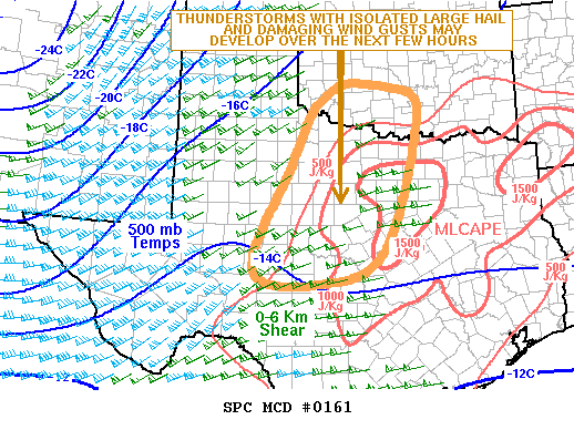
SUMMARY…A threat for isolated large hail and damaging wind gusts
will be possible over the next few hours from west-central Texas and
central Texas northward into southern Oklahoma. The severe threat
should gradually increase tonight along this corridor where weather
watch issuance will be possible.
DISCUSSION…Latest water vapor imagery shows an upper-level trough
approaching the southern Rockies with a band of mid-level moisture
extending northeastward across much of Texas. At the surface, a
synoptic-scale low is analyzed in southeast Colorado with a detached
moist sector located across the southeastern two-thirds of Texas. A
pocket of moderate instability is analyzed by the RAP over
north-central Texas where MLCAPE is estimated in the 1500 to 2000
J/Kg range. A line of convection has recently developed along the
western edge of the stronger instability to the northeast of San
Angelo. This line will be supported by large-scale ascent ahead of
the approaching upper-level trough and strong deep-layer shear,
moving eastward into increasing instability over the next few hours.
In addition, the partial 0600Z sounding from Fort Worth shows a very
steep lapse rate in the mid-levels of 9.0 C/Km. This will aid
upscale growth, enabling thunderstorms to gradually organize and
obtain a severe threat with large hail possible. A potential for
strong wind gusts may also develop later tonight as convection moves
into the instability max across north-central Texas.


0 Comments