
Welcome to the first Hump Day of February! We have a lot to talk about, even by my chatty standards. Today’s weather threats will include critical fire weather danger across the southwestern half of the Texas Panhandle, freezing fog in the northeastern Texas Panhandle, wind gusts of 40 to 55 MPH across western parts of Texas with blowing dust, more near-record high temperatures across the state, and the threat of a few severe thunderstorms this evening as a cold front arrives. That’s all just the weather we’re expecting today and tonight. Welcome to Texas folks – where you literally can have four seasons in a day.
High Wildfire Danger in the Texas Panhandle Today
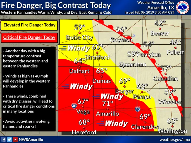
Critical fire weather conditions are anticipated this afternoon across the southwestern Texas Panhandle. Winds out of the west/southwest could exceed 50 MPH this afternoon. Relative humidity values below 20 to 25 percent and dormant surface fuels all point toward a potentially active wildfire day. Any wildland fires that develop under those conditions will have the potential to spread very rapidly and may be uncontrollable until conditions improve after sunset. Please don’t make the lives of our firefighters (many of whom are volunteers) difficult by starting a wildfire today. The high winds alone could result in arcing power lines and resultant grass fires.
We note that wind gusts may approach 45 to 60 MPH this afternoon across the Texas Panhandle and West Texas. Blowing dust is possible, if not probable. Watch out for flying tumbleweeds!
Severe Thunderstorm Potential This Evening
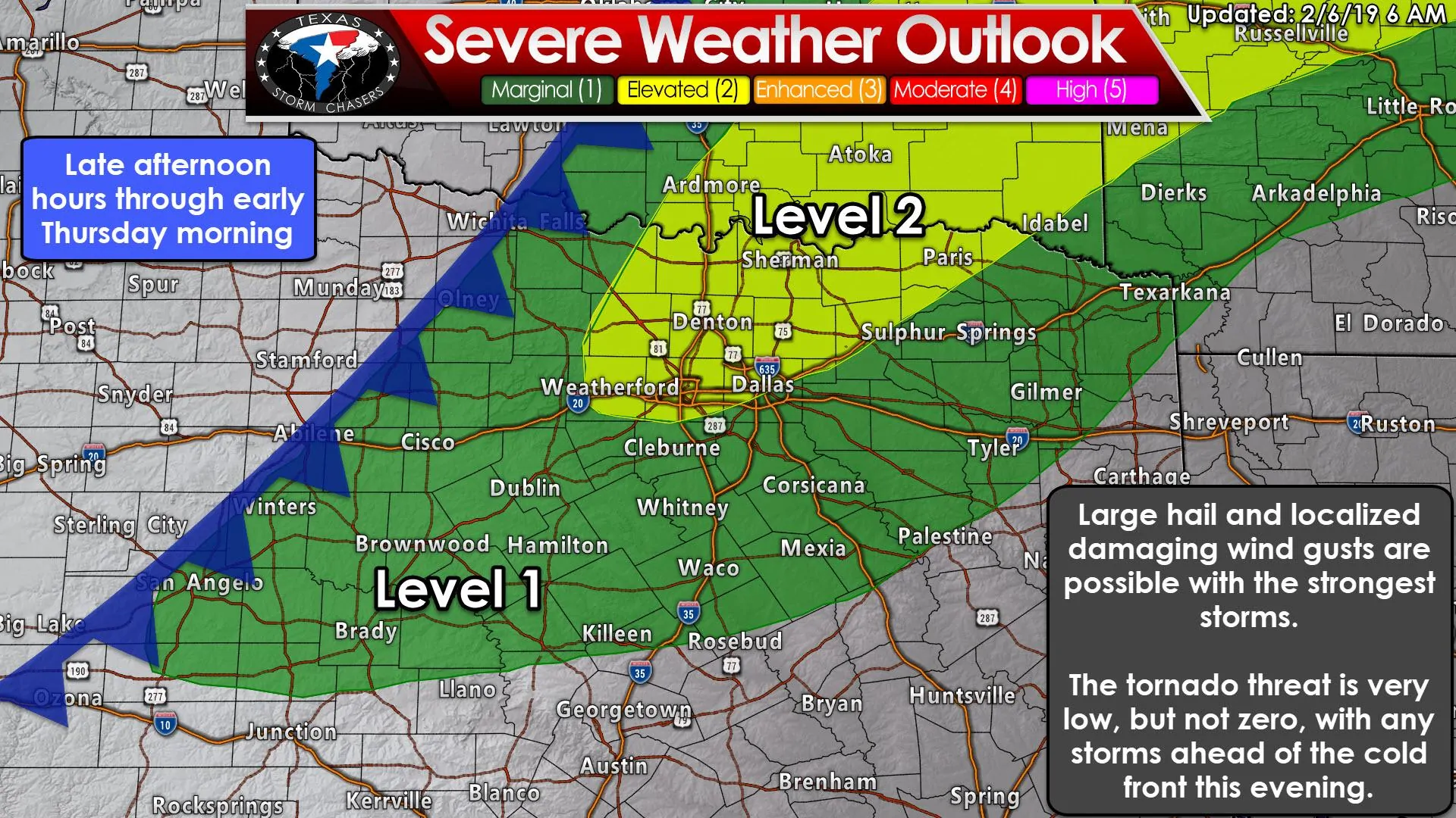
The early morning severe weather outlook from the Storm Prediction Center has placed a small corridor of North Texas and Texoma in a level 2 risk for this evening. This corridor runs along and north of a Montague to Weatherford to Fort Worth to Commerce to Paris line. A level 1 risk includes the eastern Big Country, much of North Texas, and Northeast Texas. Don’t get hung up on where the exact lines are drawn. Mother nature doesn’t read maps and doesn’t give two hoots about where outlooks are drawn. Besides, the threats will be the same if strong storms materialize in either risk zone. The following will be a lot of description versus visual display because short-range weather model don’t seem to have a great handle on the convective evolution later today. That means any ‘simulated radar’ graphic I share would probably look a lot different than what actually happens later on today and tonight. My apologies for the lack of pictures, but hopefully my ability to write pre-dawn novels will make up for it.
Large hail will be the primary and most common threat with stronger storms from the late afternoon hours through early Thursday morning. Some storms may produce localized damaging wind gusts, especially if they’re along or ahead of the cold front. A tornado cannot be ruled out, but the tornado threat seems to be higher across Southeastern Oklahoma into Northwestern Arkansas.
Thunderstorms may be underway as soon as lunch-time across Southern Oklahoma eastward into Western Arkansas. This activity will likely be in proximity to a stationary warm front (which will later become a cold front as it starts moving south). Some of those storms may impact the Red River counties of North Texas and Northeast Texas, but could very well stay to the north this afternoon.
Isolated to widely scattered thunderstorms may form during the mid to late afternoon from the eastern Big Country into North Texas. This is conditional on enough surface heating to erode any cap (inhibition) – along with there being enough upper-level lift. Should storms develop they could become strong enough to produce large hail.
There are some indications that widely scattered thunderstorms or a small cluster of storms may move northeast across eastern North Texas and North Texas around dinner-time into the early evening hours. This activity would have a higher potential of becoming severe with a threat of large hail, localized damaging wind gusts, and a low-end threat of producing a tornado. It remains unclear if these storms would be surface-based (as in, capable of producing all-hazards), or slightly elevated above a cap just above the surface (which would greatly reduce the threat of damaging winds/tornado). Either scenario would result in a hail threat.
For most folks, the ‘main show’ will not be until the late evening hours tonight and into the early morning Thursday. A cold front will move south/southeast with the potential of thunderstorms along that front in Texoma and North Texas this evening and overnight. Some of the storms may be strong with frequent lightning, hail, and localized gusty winds. Thunderstorms may also develop this evening along with a pseudo-dryline located across the Hill Country and western North Texas. Those storms could also be strong to severe if they develop. The threat of severe storms will decrease after midnight as storms get undercut (outrun) by the cold front.
Overall the threat of severe weather is not high today and we’re not currently expecting a widespread severe weather event. Most storms tonight may end up being undercut by the cold front, thus cutting off most of their supply of unstable air. It’s always a good idea to check back throughout the day for forecast updates just in case something changes. Al Moller (former meteorologist at the National Weather Service) used to say “When it comes to storms, expect the unexpected.” That’s a great philosophy to live by for many things weather.
Northerly winds of doom bring an arctic blast and a temperature drop of 30 to 40 degrees
Warm weather fans should take time today to cherish the warmth. Cold weather fans only need hold off another day or so until they can head outside and freeze their tushie to their heart’s content. I’m actually a winter fan myself so I can’t judge too much. However, without snow, I’m not as much of a cold weather dude. Add in the annoyingly unpleasant wind chill values and I quickly turn into a warm weather fan – until summer.
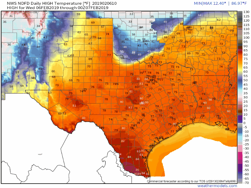
The cold front will make progress on Thursday from north to south. Temperatures behind the front will not climb much – if at all – on Thursday as northerly winds of doom keep the cold air advection wide open. This will result in several locations experiencing their ‘high temperature’ during the morning hours. Those south of the front on Thursday will get to enjoy another day of 60s and 70s. That is until the cold front arrives and temperatures drop 30 to 40 degrees over the following few hours.
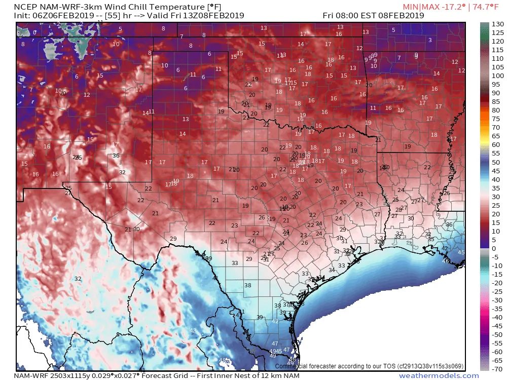
Model-projected wind chill values around 7 AM Friday
Here’s a look at model-projected wind chill values around 7 AM on Friday. Those dark purples aren’t the color of my saggy eyelids but signify wind chill temperatures in the single digits across the Texas Panhandle. Wind chill values in the teens can be expected along and north of Interstate 20 – including the D/FW metroplex east to Shreveport. Farther south, wind chills down in the 20s can be expected along and north of Interstate 10, including San Antonio to Houston, with 30s across South Texas. Those in the Rio Grande Valley may escape the worst of it, but it’ll still be cold by Rio Grande Valley standards.
We’ll experience a moderation trend by Sunday and Monday as temperatures climb the temperature roller coaster into the 50s and 60s, but another cold front is expected around Tuesday of next week.


0 Comments