
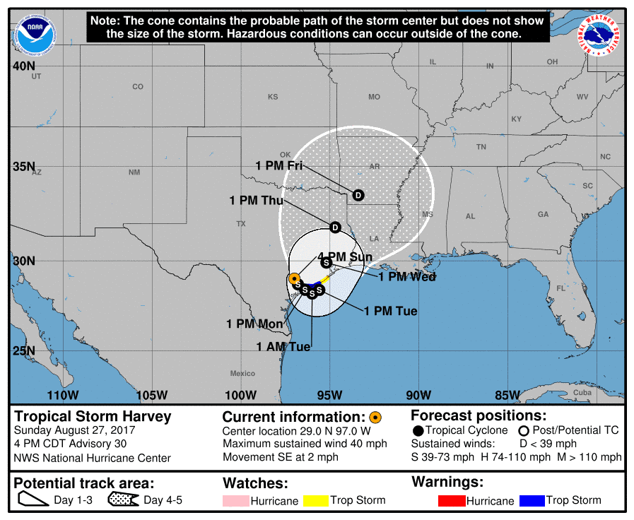
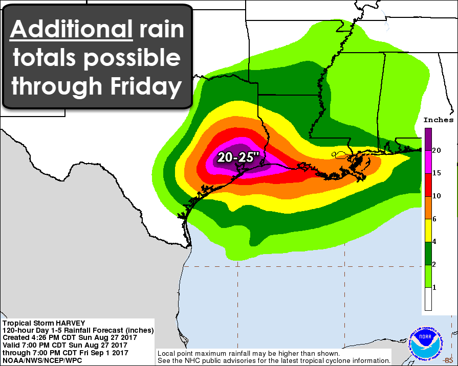
The center of tropical storm Harvey is located 25 miles northwest of Victoria this afternoon. Harvey is now moving southeast at a walking pace of 2 MPH. This southeastward movement will continue into Monday when Harvey moves off-shore near the same location it made landfall a few days ago. This will result in Harvey moving back into the Gulf of Mexico. The very slow forward movement will continue with a turn to the northeast expected on Tuesday. The center Harvey should move back on-shore late Tuesday night near Freeport to Jamaica Beach. Once Harvey moves back into the Gulf there is the possibility for some re-organization. I don’t expect much in the way of a wind speed increase – maybe 5 to 10 MPH, but being back over the Gulf will probably help Harvey pick up more moisture. By Wednesday afternoon the center of Harvey could be located very Houston with the forward motion finally increasing. By Thursday afternoon the center could be located near Lufkin and by Friday hopefully, Harvey will be in Arkansas. The heaviest rains are expected to the east of Harvey’s track – hence once we get Harvey over Houston and northeast of Houston by Wednesday the threat for ridiculous additional amounts of rain should finally decrease. We’ve still got a very long way to go between now and Wednesday. In addition to the obvious flooding threat, the potential for isolated tornadoes will continue through Tuesday in Southeast Texas and Southwest Lousiana. That tornado threat may begin shifting north into East Texas by mid-week as Harvey begins to move further northeast.
From NWS Houston:
…Continued potential for devasting flooding over the next
several days from Harvey’s rainfall….DISCUSSION…
Rainfall from Harvey continued to produced catastrophic and life-
threatening flooding across portions of Southeast Texas this
afternoon. Rainfall over the past 48 hours has exceded 12 inches
with a large part of the area receiving in excess of 20 inches.
This has led to a long-period flash flood emergency in these
locations.Unfortunately, the center of TS Harvey was located just west of
Jackson County. Rain bands moving into SE Texas will lead to
additional heavy rainfall this afternoon and tonight. The rainfall
potential over the next three days is 15 to 25 inches with
localized higher amounts. Isolated tornadoes will continue to be
a threat in the rain bands to the east of the storm’s center.Stay tuned to the latest advisories on Harvey for the forecast
track of Harvey.
Houston may get a lull in the heavy rain through dinner time, but the band of rain southwest of Houston may intensify and bring an additional 2 to 5 inches of rain to Harris County during the middle and late evening hours. Any additional rainfall in Southeast Texas – including Houston – will cause additional flash flooding. The heavy rainfall has been expanding today across the Brazos Valley and in Southeast Texas – around Liberty to High Island in particular where a heavy rain band has been moving over the same areas this afternoon. Keep in mind that even the weaker looking echoes on the radar in the Brazos Valley and Southeast Texas are producing up to an inch of rain per hour due to tropical moisture in place. It will not be prolifically raining over all parts of Southeast Texas over the next 3 days. There will be lulls in-between heavy rounds of rain.
Use the Texas Water Dashboard to check on Stream/River Conditions & Forecasts
#Harvey's heavy rainfall isn't over yet – an additional 10-25 inches expected over the next 5 days for much of the area #houwx #glswx #txwx pic.twitter.com/4hVDdXi2lH
— NWS Houston (@NWSHouston) August 27, 2017
5:17p 8/27 – Our highest rainfall total so far is 20.26 inches from Smithville Texas. Graphic is an overview of storm total rainfall. pic.twitter.com/pOBvmCBHiv
— NWS San Antonio (@NWSSanAntonio) August 27, 2017
3" to 6" of rainfall are expected from TS #Harvey over the next week. Isolated higher amounts in excess of 8" possible over parts of E TX. pic.twitter.com/1ce7N61pwC
— NWS Shreveport (@NWSShreveport) August 27, 2017
By Tuesday-Friday the threat for several inches of rainfall will spread north into East Texas as the system moves north. That could cause additional flooding – both flash flooding and river flooding. Remember, whatever rains fall further north will have to go through the severely impacted Southeast Texas watersheds to exit into the Gulf.


0 Comments