
Scattered showers and thunderstorms are expected for one final day across the eastern half of Texas. The highest chance will generally be across the eastern half of North and Central Texas, Northeast Texas, East Texas, Southeast Texas, the Brazos Valley, and Middle Texas Coast. Isolated to widely scattered storms are possible across South Texas and the Rio Grande Valley this morning through the evening hours – as evidenced by the ongoing thunderstorm cluster moving south.
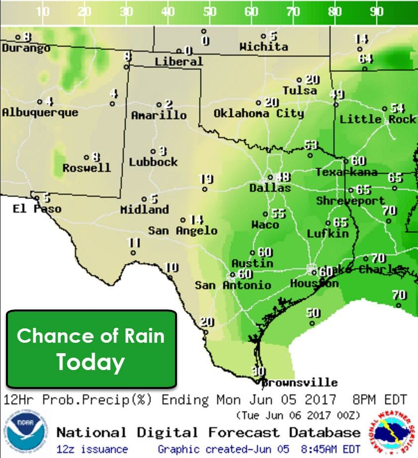

As with the past several days we’ll see the highest coverage of thunderstorms during the afternoon hours. Most of the activity will be diurnally driven which is typical for summer-time activity. A few of the strongest storms, outside the Middle Coast south to the Rio Grande Valley, may produce small hail and localized damaging wind gusts. The primary concern will be for heavy rainfall and flash flooding. It’ll be another day where one location may get several inches of rain while another a few miles away gets almost nothing. The concern over flash flooding will be heightened for locations that have already received heavy rainfall over the past couple of days. Isolated to widely scattered activity may continue into the evening hours with the best chances over East Texas, the Brazos Valley, and Southeast Texas.
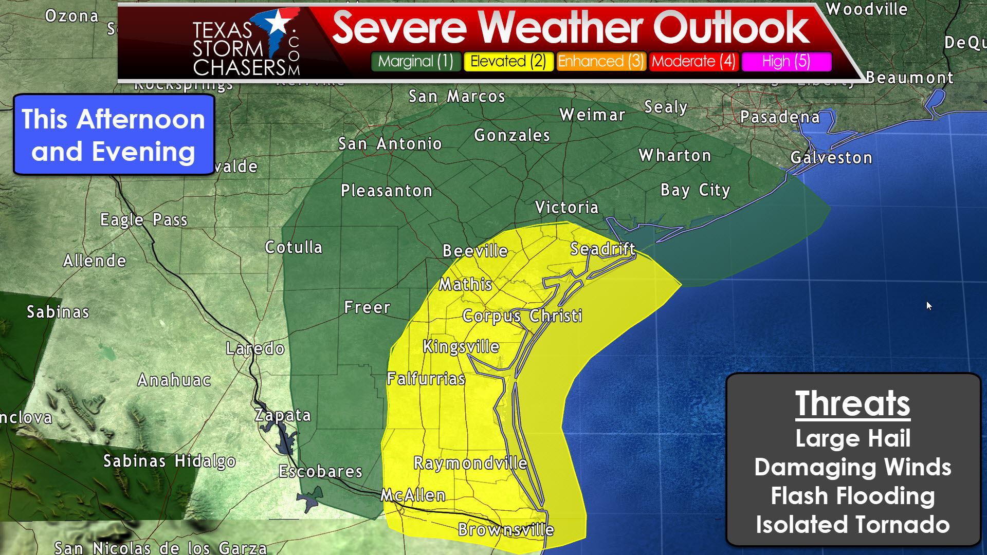
Now lets talk specifically about the Coastal Bend south into the Rio Grande Valley. An upper-level low is slowly moving east into the western Gulf of Mexico today. The presence of that upper-low (non-tropical in nature) will create adequate wind shear to support a more organized convective mode this afternoon. A level 2 (standard) risk of severe weather includes those two regions. Seadrift, Beeville, Corpus Christi, Kingsville, Falfurrias, Raymondville, McAllen, Brownsville, and South Padre Island are included in the risk area. A level 1 (marginal) risk includes South Texas and Middle Texas Coast. Freer, Pleasanton, San Antonio, Gonzales, Victoria, Weimar, Wharton, and Bay City are a few towns included. Severe storms aren’t a guarantee but there will be a risk. The strongest storms, should we see them occur, will probably be during the mid-afternoon to early evening hours. Threats include large hail, damaging wind gusts, flash flooding, and a low threat for a tornado. Just as with activity further north flash flooding and very heavy rainfall will be a concern. The risk of severe storms will decrease by the mid to late evening.
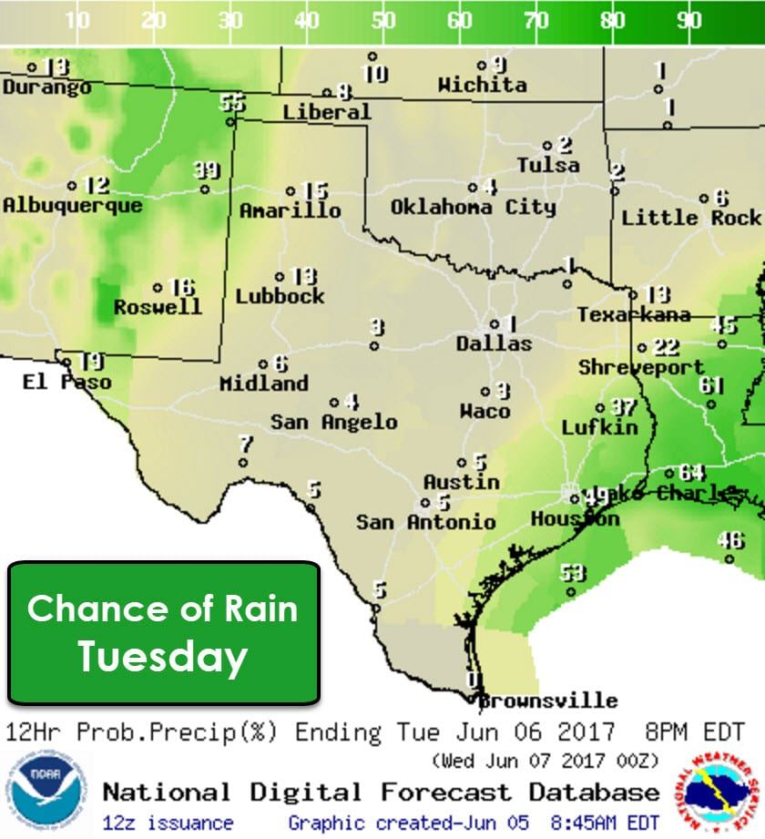
Scattered showers and storms are expected again on Tuesday in Southeast Texas, but areas farther west along I-35 will finally have a chance to dry out. Isolated to scattered storms will become a daily threat for the Texas Panhandle, West Texas, and the Borderland starting on Tuesday and continuing daily through at least Thursday. Some of the storms could be strong with a chance of hail and damaging wind gusts. Localized flash flooding is also going to be a threat.


0 Comments