
The Storm Prediction Center has indicated a severe weather watch will likely be issued by 4 PM for parts of Central Texas and the Brazos Valley. A slow-moving cold front will continue to push south this afternoon. Scattered thunderstorms will likely begin developing near this front over the coming hours. Some of the storms may produce large hail and damaging wind gusts. The tornado threat is low, but not zero. See Jenny’s blog from this morning for more specifics. Also, you can track any weather mischief using our weather radar here on the site. Just click the link at the top of this page.
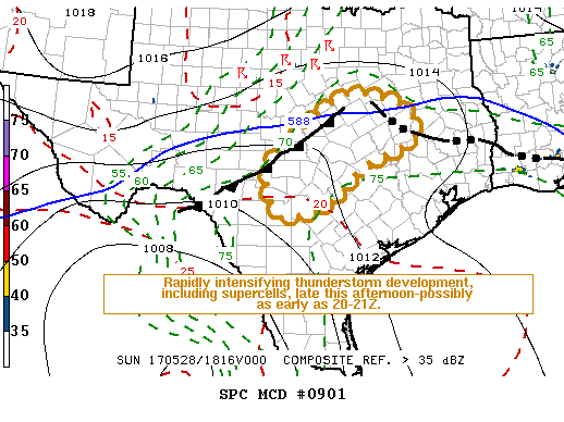
Mesoscale Discussion 0901
NWS Storm Prediction Center Norman OK
0134 PM CDT Sun May 28 2017
Areas affected…Central Texas
Concerning…Severe potential…Watch likely
Valid 281834Z – 281930Z
Probability of Watch Issuance…80 percent
SUMMARY…A severe weather watch seems probable at some point late
this afternoon and evening, perhaps as early as 20-21Z.
DISCUSSION…Objective analysis indicates that insolation within a
boundary layer characterized by high moisture content (lower/mid 70s
F surface dew points) is contributing to strong/extreme CAPE on the
order of 4000+ J/kg across much of the region, including the
Interstate 35 corridor between San Antonio and Waco. Mid-level
inhibition beneath warm elevated mixed layer air does still appear
considerable, particularly given weak, or at least unclear,
mid/upper forcing for ascent. An area of enhanced ascent
contributing to deepening mid-level based convection near the
Interstate 20 corridor, west of the Dallas/Fort Worth metroplex, may
remain displaced to the north of an area of sustained enhanced
low-level convergence near the Waco area. This is near the
intersection of a surface front that extends southwestward into the
Rio Grande Valley, to the west of Del Rio, and the western flank of
composite outflow from extensive overnight convection, now advancing
into the north central Gulf Coast.
However, the latest Rapid Refresh suggests that additional surface
heating, coupled with subtle mid-level height falls on the southern
fringe of the westerlies, may be sufficient to support the
initiation of thunderstorms as early as 20-21Z. Once this does
occur, intensification likely will be very rapid, and deep layer
shear appears sufficient for the evolution of supercell structures
with large hail and perhaps an isolated tornado, in addition to
strong downbursts accompanied by potentially damaging surface gusts.


0 Comments