
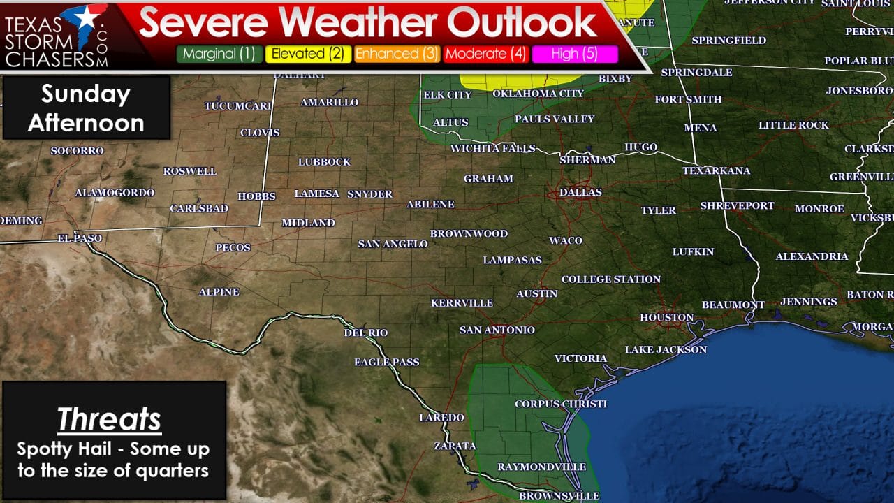
Good evening folks! I hope you were able to get outdoors today and enjoy the excellent spring weather. After an active past week it was great to see all the sunshine pictures roll in today. Sunday – for most – will be another relatively decent day although it will be noticeably winder with south winds. What we will be watching for is the chance for a few strong to marginally severe storms in the Rio Grande Valley Sunday afternoon. The folks at the Storm Prediction Center have highlighted a marginal risk of severe weather in the Rio Grande Valley tomorrow afternoon. We could see a few stronger storms produce hail during the afternoon hours. By no means do I expect a widespread/significant problem tomorrow but there could be a few stronger storms mixed in with showers/storms. Rain chances will quickly diminish with northward extent. A strong cap will prevent thunderstorm development along the dryline tomorrow in Texas. However a couple supercells will probably fire up in northern Oklahoma and southern Kansas with very large hail and a couple tornadoes possible. We will be chasing tomorrow so check back for our live video stream on YouTube or on our website here. Monday will be very unstable across North Texas and Texoma but a strong cap is expected to keep thunderstorms from developing.
Tuesday has the potential to be a very active severe weather day across the Southern Plains of the United States. At the moment the most likely regions to be impacted by a severe weather outbreak include Central and Southern Kansas (roughly 30-50 miles west of 135 and extending east), Central and Eastern Oklahoma, and Texoma. The Storm Prediction Center already has an enhanced severe weather risk in place for those regions. A stronger cap will likely help keep thunderstorm numbers limited here in Texas ahead of the dryline. However I do anticipate a couple supercells will develop east of the dryline by the late afternoon hours on Tuesday. The ‘best’ chance for that right now is in Texoma into western North Texas. Storms that develop will move east/northeast. A couple storms may also fire up in the Hill Country as temperatures warm into the 80s. All storms that develop on Tuesday will do so in an enviornment supportive of severe weather. The most significant severe weather threat in Texas will likely be very large to giant hail. Some hail stones could be larger than the size of a baseball. Tornadoes will be possible – especially from North Texas and northward. I’m hopeful low-level wind shear will be weaker south of the river compared to Oklahoma and Kansas.
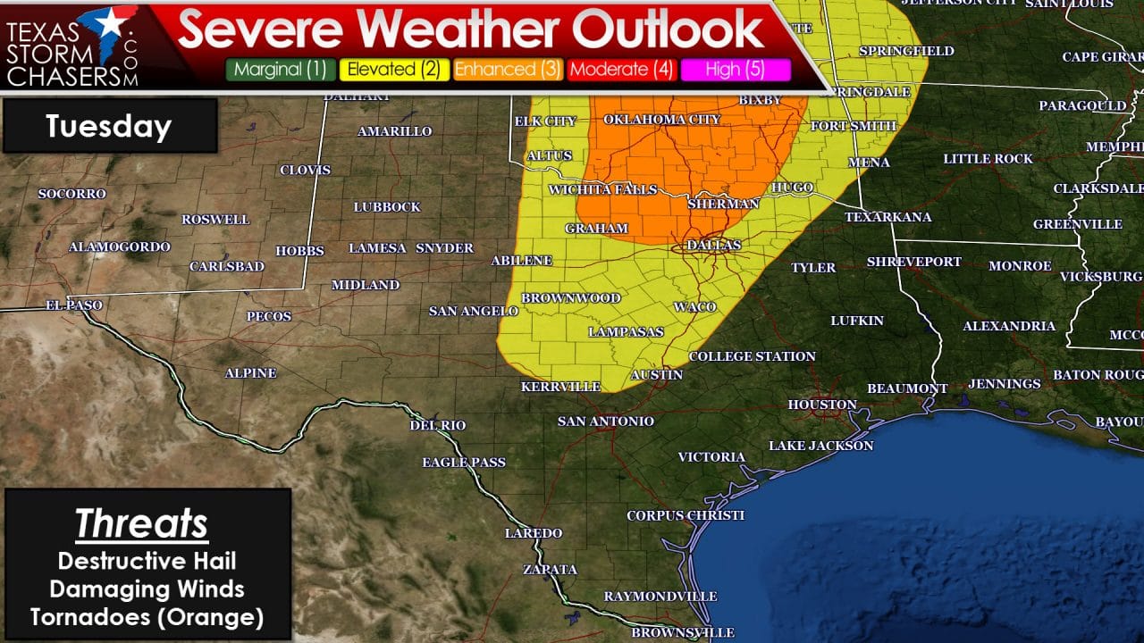
We’ll have to continue to refine the severe weather threats as we get closer to Tuesday. This is spring in Texas so these threats are not unusual or historic. However Tuesday could be a rather busy day with all modes of severe weather possible. A significant severe weather outbreak is becoming more likely in Kansas and Oklahoma. Storms would most likely occur after 3-4 PM here in Texas and could congeal into a squall line by the evening hours. If that line develops it could continue to push east/southeast into the night hours with a widespread damaging straight-line wind threat along with hail and isolated tornadoes.

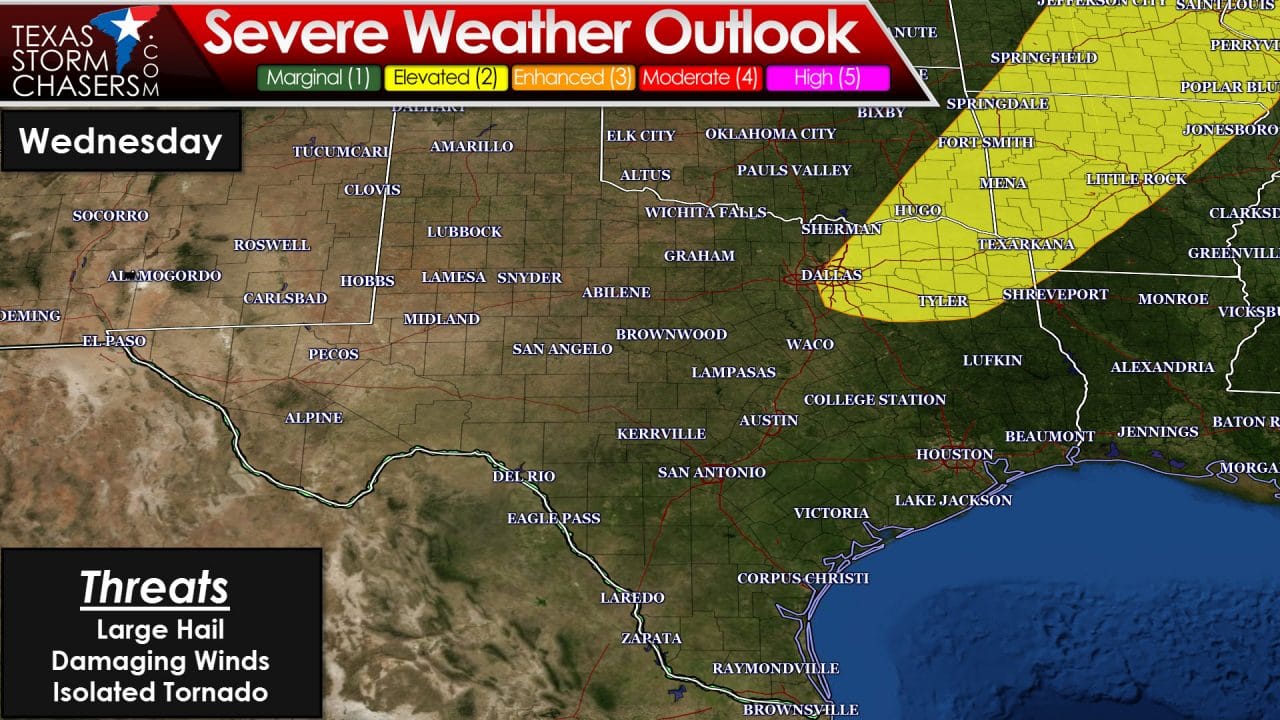
The threat for severe thunderstorms will continue on Wednesday in North and Northeast Texas. What happens on Tuesday will play a role into what develops on Wednesday so I won’t get too much into that extended range at this time. Additional storms are possible on Thursday and Friday – some of which may also be severe. With an upcoming active week I encourage you to check back for forecast updates and have multiple ways of receiving weather warnings. Follow your local National Weather Service office along with a preferred media source.


0 Comments