Flooding across many parts of south central Texas continues this evening and will remain a threat for the next several days. Another area of rain is moving from west to east across south central Texas and will likely impact the Houston metro area during the overnight hours. While this next batch of rain is not expected to be as heavy, and will move across the region a bit more quickly than this morning’s system, an additional 1 to 2 or more inches is still possible overnight. While that may not seem like much, any additional rainfall across this area will only exacerbate current flood conditions. With so many roadways remaining closed and flooded tonight in and around the Houston metro area, local officials are asking area residents to stay home tonight and not venture out unless it’s extremely urgent.


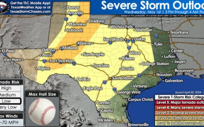
For the remainder of the state overnight, showers and storms (non-severe) are possible across parts of the panhandle. Don’t be surprised if you are awakened by a few boomers overnight. Ongoing storms across deep south Texas will continue to impact the region overnight. A few of these could become severe with a hail and damaging wind threat; however widespread severe weather is not expected. Thankfully for Tuesday, weaker upper level flow aloft will greatly diminish the the threat of severe weather during the early to middle portions of the day with only a small marginal risk across a small area of west Texas around the Ft. Stockton area. The heaviest rain tomorrow should be confined mainly to the eastern half of the state with overall rainfall totals less than 2 inches for most; however, localized higher amounts cannot be completely ruled out wherever the heaviest bands of rain set up.
For late Tuesday into Wednesday, the threat of severe weather returns to parts of north central and central Texas as the stagnant upper level low moves east. Forcing will be on the increase by Tuesday afternoon and evening and bring chances for more widespread showers and a few storms across northwest and west central Texas. Overnight Tuesday into early Wednesday, it’s possible we’ll see even more widespread coverage of showers and storms across the region with a few of the short-range models showing the possibility of a squall line of storms moving across the region Wednesday morning. Wednesday afternoon and evening may also have a risk of additional severe storm development across central Texas. With this still being two days out, we expect this forecast to be refined by tomorrow, so be sure to check back with us!


0 Comments