
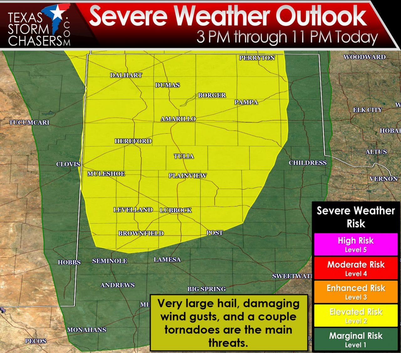
The Storm Prediction Center has highlighted the Texas Panhandle and South Plains in the standard level 2 risk of severe weather for late this afternoon and this evening. A level 1 risk includes the Permian Basin and locations just east of the Caprock. This afternoon is definitely one where keeping an eye on the weather could pay off. The potential exists for a couple intense, discrete supercells after 3 PM. This storms would likely fire up towards the TX/NM border and move northeast. Very large hail up to the size of baseballs could fall out of the strongest of the storms. The threat for a couple tornadoes looks to increase after 5 PM and continue through 10 PM as storms move northeast. Localized damaging wind gusts are also possible. The most likely threat zone for tornadoes looks to be across the northern Texas Panhandle early this evening – but we need to watch for any intense discrete storms that form in the northern sections of the South Plains and the remainder of the Panhandle. There is some uncertainty on how strong the cap will be with southward extent. Have multiple ways of receiving weather warnings and check back with your preferred weather source for updated information. The National Weather Service offices in Amarillo and Lubbock are both great resources to follow.

The Storm Prediction Center has highlighted the standard level 2 risk of severe weather on Saturday for the Texas Panhandle, South Plains, Rolling Plains, Permian Basin, Big Country, Concho Valley, south to the Mexico border from Del Rio west to south of Fort Stockton. Widespread cloud cover may hamper instablity values and keep the atmosphere more stable. Wind shear values will be very supportive of organized thunderstorms. If we can get the right mix of instablity and wind shear there could certainly be a threat for a few supercells Saturday afternoon into Saturday evening. The most intense discrete storms on Saturday afternoon could be supercellular with large hail up to the size of golfballs, damaging winds The threat for severe storms – mainly in the form of hail – looks to continue into the nighttime hours Saturday as thunderstorm coverage increases due to the approaching upper level storm system.
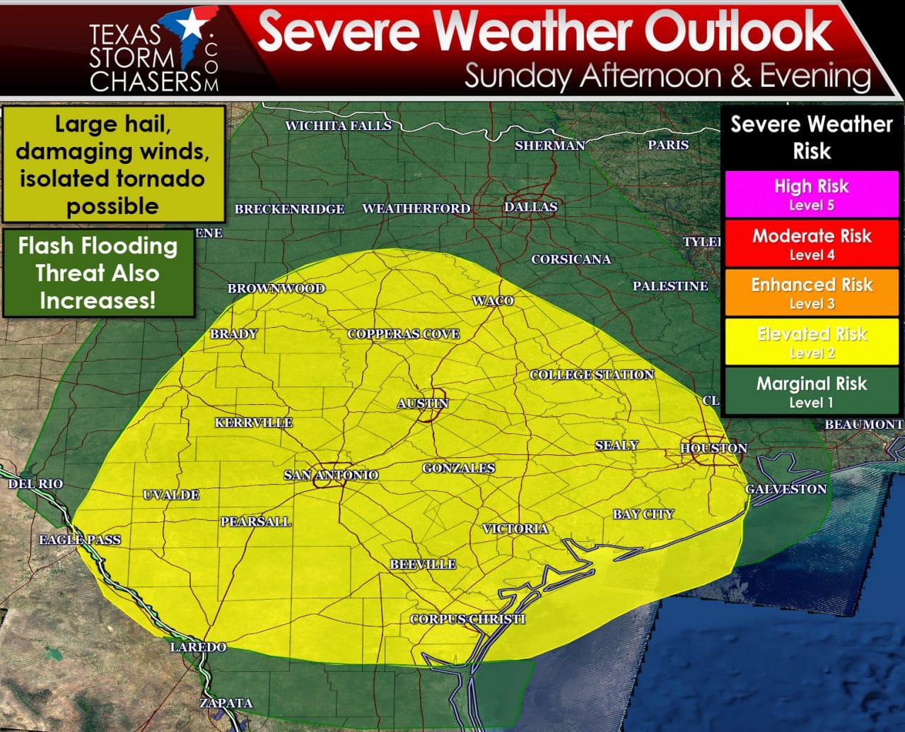
The Storm Prediction Center has highlighted the standard level 2 risk of severe weather on Sunday for the Hill Country, South-Central Texas, Central Texas, the Brazos Valley, the Coastal Plains, and the Middle Texas Coast. A level 1 risk includes Southeast Texas, the Rio Grande Valley, North Texas, and Texoma. Widespread rain is expected north of a frontal boundary draped across Central Texas on Sunday. That widespread rain should keep the overall severe weather threat on the lower end of the spectrum across Northwest Texas and North Texas. South of the frontal boundary we are anticipating a more unstable airmass. Assuming we can get a few hours of sun/cloud mix the atmosphere should become unstable enough to support organized thunderstorms. Wind shear values will be very supportive of organized thunderstorms. The strongest storms may produce large hail, damaging wind gusts, and an isolated tornado during the late afternoon and early evening hours Sunday. As we get closer to Sunday we’ll be able to further refine the severe weather threat.
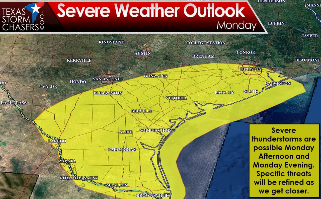
Severe thunderstorms will be possible on Monday across South Texas, the Rio Grande Valley, the Coastal Plains, and Southeast Texas. Due to several preceding days of storm potential and the extended range of the forecast we’re not able to be more specific regarding any potential severe weather threats. We’ll refine the risks as we get closer to Monday and get a better handle on events preceding Monday. Don’t be surprised to see the outlook changed as we refine the forecast.
Rain chances will continue to increase over the coming days. The above graphics indicate the 12 hour rain probabilities for each of those periods based on the forecasts this morning from the National Weather Service. Uncertainty increases with spatial extent so don’t be surprised if rain chances are refined in the longer range. It won’t be raining all the time in all the places over the next five days. There are certainly going to be times where it’s a washout though.
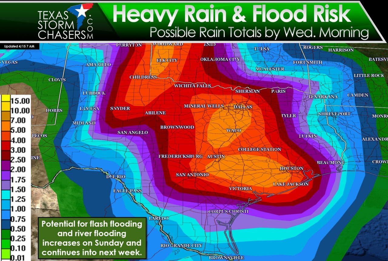
A widespread and fairly significant rain event is forecast across the eastern two-thirds of Texas over the next five days. Widespread rain accumulations of 1 to 3 inches are forecast with isolated rain totals up to 7 inches possible. It is not out of the question we see a very localized rain total approach 10 inches if we have a significant event develop. The possibility of flooding increases Saturday/Saturday Night across the eastern Texas Panhandle, Northwest Texas, and the Big Country. Sunday will see the threat of flooding increase across Northwest Texas, North Texas, Central Texas, the Big Country, and Hill Country. Sunday will see the flooding threat increase into South-Central Texas, the Brazos Valley, Southeast Texas, and continue into next week. While forecast refinements are expected I do anticipate a large number of Texas counties going under a flash flood watch in the next day or two. Dry weather will allow the first couple of inches of rain to be absorbed into the ground. After that runoff will become a problem with an increasing flood threat. Flash flooding will be a problem initially with river flooding a prolonged threat into the next 7-10 days. Some authorities are already releasing water from lakes in anticipation of the upcoming rain event.


0 Comments