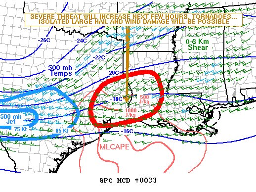
The Storm Prediction Center has indicated that they will likely be issuing a tornado watch for parts of Southeast Texas within the next few hours. Conditions are becoming more favorable for the development of a few severe thunderstorms. The primary threat in Southeast Texas would be quarter size hail and localized damaging wind gusts over 60 MPH. The tornado threat will increase as storms approach the Louisiana border with the highest tornado threat in Louisiana and Mississippi. Severe storms should exit Texas to the east by 4 PM but we could continue to see sub-severe storms in Northeast and East Texas through early this evening.
MESOSCALE DISCUSSION 0033
   NWS STORM PREDICTION CENTER NORMAN OK
   1059 AM CST THU JAN 21 2016

   AREAS AFFECTED...SE TX...LA

   CONCERNING...SEVERE POTENTIAL...WATCH LIKELY

   VALID 211659Z - 211900Z

   PROBABILITY OF WATCH ISSUANCE...80 PERCENT

   SUMMARY...THE SEVERE THREAT ACROSS SE TX AND WRN TO CNTRL LA WILL
   INCREASE OVER THE NEXT FEW HOURS. TORNADOES...ISOLATED LARGE HAIL
   AND WIND DAMAGE WILL BE POSSIBLE WITH THE STRONGER STORMS. A TORNADO
   WATCH WILL LIKELY BE NEEDED ACROSS THE REGION LATE THIS MORNING.


0 Comments