
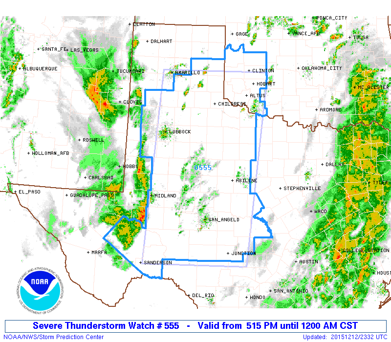
The Storm Prediction Center has issued a Severe Thunderstorm WATCH for parts of the eastern Texas Panhandle, northwest Texas, west central Texas, Permian Basin and Big Country regions of west central Texas until midnight. In the past half hour, isolated storms have developed out ahead of the front across the southeastern and eastern panhandle region and are quickly moving off to the east/northeast. Additional squall line development has also been noted just west of the Midland/Odessa area. The squall line will further develop both northward and southward over the next several hours and will track quickly east. The main threats with all the storms across this area his evening will be the chance for damaging winds and hail up to the size of half-dollars. The tornado threat remains low but not completely ruled out given the dynamics in place. Have a way to receive weather warnings and be prepared to seek shelter immediately if a warning is issued for your area.
NWS STORM PREDICTION CENTER NORMAN OK
   515 PM CST SAT DEC 12 2015

   THE NWS STORM PREDICTION CENTER HAS ISSUED A

   * SEVERE THUNDERSTORM WATCH FOR PORTIONS OF
     SOUTHWEST OKLAHOMA
     WEST TEXAS

   * EFFECTIVE THIS SATURDAY AFTERNOON FROM 515 PM UNTIL MIDNIGHT
     CST.

   * PRIMARY THREATS INCLUDE...
     SCATTERED DAMAGING WIND GUSTS TO 70 MPH LIKELY
     ISOLATED LARGE HAIL EVENTS TO 1 INCH IN DIAMETER POSSIBLE
     A TORNADO OR TWO POSSIBLE

   SUMMARY...A LINE OF STRONG TO SEVERE THUNDERSTORMS WILL DEVELOP THIS
   EVENING OVER WEST TX...TRACKING QUICKLY EASTWARD ACROSS THE WATCH
   AREA.  LOCALLY DAMAGING WINDS ARE THE MAIN THREAT...ALONG WITH SOME
   HAIL IN THE STRONGEST CELLS.  AN ISOLATED TORNADO CANNOT BE RULED
   OUT.

   THE SEVERE THUNDERSTORM WATCH AREA IS APPROXIMATELY ALONG AND 95
   STATUTE MILES EAST AND WEST OF A LINE FROM 65 MILES WEST
   SOUTHWEST OF JUNCTION TEXAS TO 60 MILES NORTH OF CHILDRESS TEXAS.
    FOR A COMPLETE DEPICTION OF THE WATCH SEE THE ASSOCIATED WATCH
   OUTLINE UPDATE (WOUS64 KWNS WOU5).

   PRECAUTIONARY/PREPAREDNESS ACTIONS...

   REMEMBER...A SEVERE THUNDERSTORM WATCH MEANS CONDITIONS ARE
   FAVORABLE FOR SEVERE THUNDERSTORMS IN AND CLOSE TO THE WATCH
   AREA. PERSONS IN THESE AREAS SHOULD BE ON THE LOOKOUT FOR
   THREATENING WEATHER CONDITIONS AND LISTEN FOR LATER STATEMENTS
   AND POSSIBLE WARNINGS. SEVERE THUNDERSTORMS CAN AND OCCASIONALLY
   DO PRODUCE TORNADOES.


0 Comments