
Good Wednesday Morning! Let me start out by thanking all our military personal and emergency service workers for their service to our country. Without their dedication we would not have the privilege of writing this blog for you this morning. I wish I could say the weather was going to be nice across Texas today but we do have an intense storm system passing just to our north. A variety of impacts are expected across Texas today. I’ve broken them down into sections below. Lets get started!
For locations west of Interstate 35 this will be a dry day with increasing west/northwest winds. Locations in Northeast Texas, East Texas, and Southeast Texas will have the chance to see showers and a couple of storms today as a dryline/cold front push east. The 5 AM run of the High Resolution Rapid Refresh (HRRR) weather model seems to depict the situation well enough At 2 PM it has scattered showers and thunderstorms in progress across the areas I mentioned above. Some of the storms may be strong to severe with locally damaging wind gusts. Individual storms will move off to the east/northeast in a hurry. A thin but broken line of storms may fire up on the leading edge of the dryline/cold front this afternoon. That front will move east/southeast with the line of storms doing the same. Not everyone will see storms nor will everyone get wet. A few of the storms may produce damaging wind gusts over 60 MPH. The intense storm system responsible for our active weather is passing to our north. If it were closer to Texas we’d have a far greater severe weather threat today.
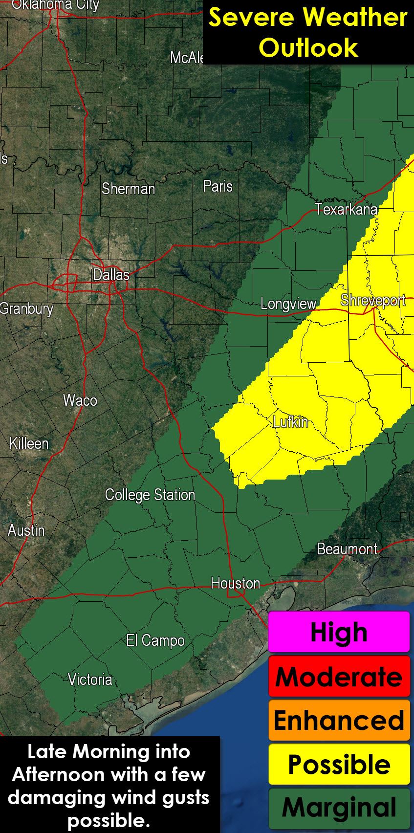
There is the possibility of a few severe thunderstorms later this morning into the afternoon hours. A category 1/marginal risk for severe weather is in place across the Brazos Valley and Southeast Texas. A category 2/possible risk is in place across Northeast and East Texas. The difference in those two risk levels means confidence is slightly higher in a few severe storms in the Cat. 2 risk versus the Cat. 1 risk. I expect any severe weather threat to be relatively localized today. The primary risk from the stronger storms will be damaging wind gusts over 65 MPH. With very strong winds in place above the surface it won’t take too strong of a storm to help mix those winds down to the ground. A brief tornado is not totally out of the quesito but the overall risk is very low. Likewise I don’t think we’ll have too much of a hail problem today. Flash flooding should not be an issue we have to worry about either.
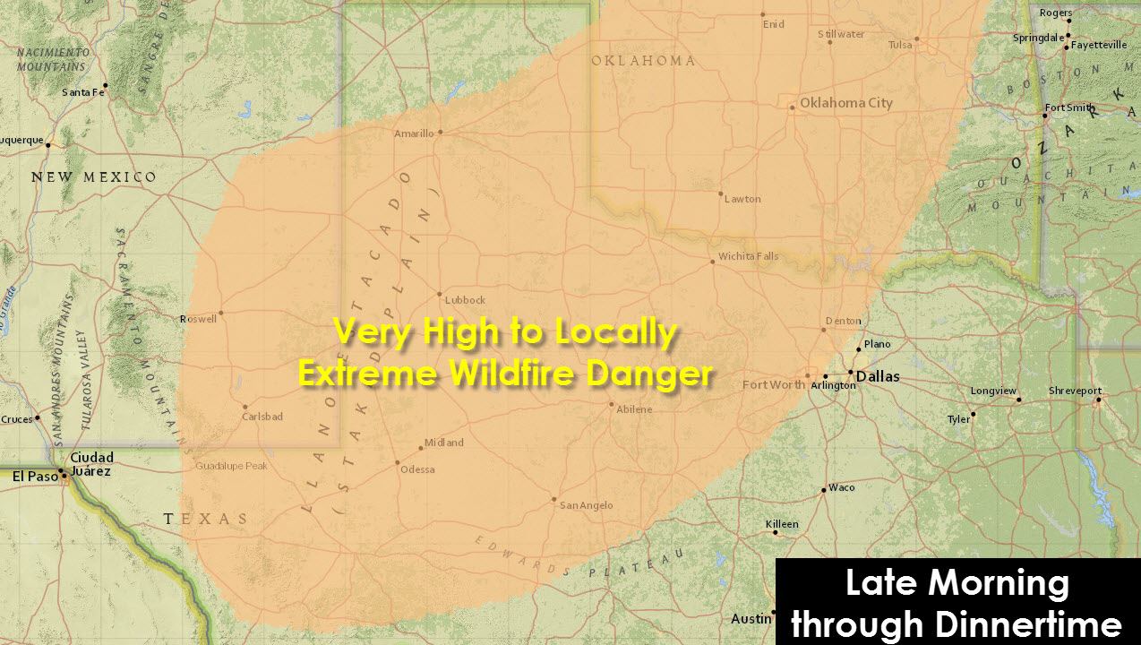
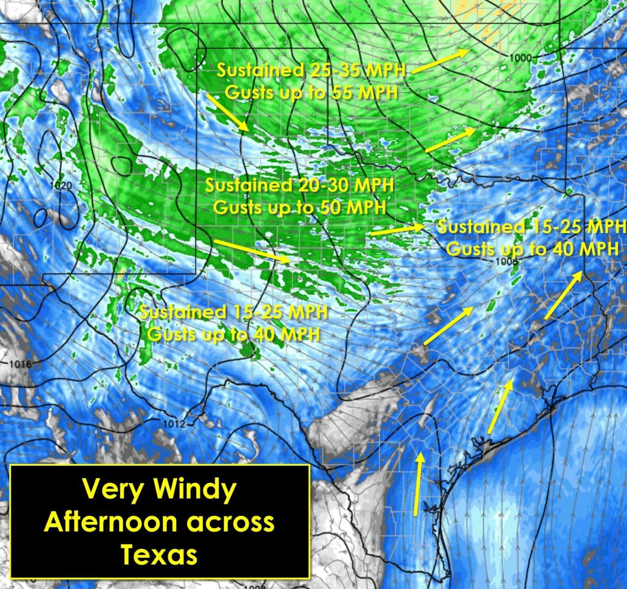
Clouds will quickly clear out behind the dryline today. Dewpoint and humidity values will plummet creating elevated fire danger. Very strong winds a few thousand feet above the ground will partially mix down as the sun comes out and warms temperatures. Strong to very strong winds along with the low humidity values will promote very high to extreme fire danger by late morning into the afternoon hours across the Texas Panhandle, West Texas, Northwest Texas, the Big Country, and North Texas. Any fires that develop will have the potential to spread rapidly and require significant resources to contain. The dry strong winds will quickly dry out grasses helping to promote the fire threat – even in areas that received rain recently. Outdoor burning or use of flame is a bad idea this morning or afternoon. Winds will quickly diminish by the evening hours as the pressure gradient loosens due to the storm system moving away. Light winds will continue into Thursday morning.

Compressional heating along with strong south winds will make for a very warm day in the Rio Grande Valley and South Texas as high temperatures climb into the lower 90s. The rest of Texas will be at the mercy of the cold front. Temperatures this morning are generally in the 60s to low 70s ahead of the front. The further south and east you are the warmer you’ll get today with upper 70s to 80s. Folks in the Panhandle and West Texas will stay in the 50s as the cold front has already arrived. Once the cold front arrives at your location you can expect temperatures to drop. Thus your high temperature may be this morning with falling temperatures this afternoon or evening.
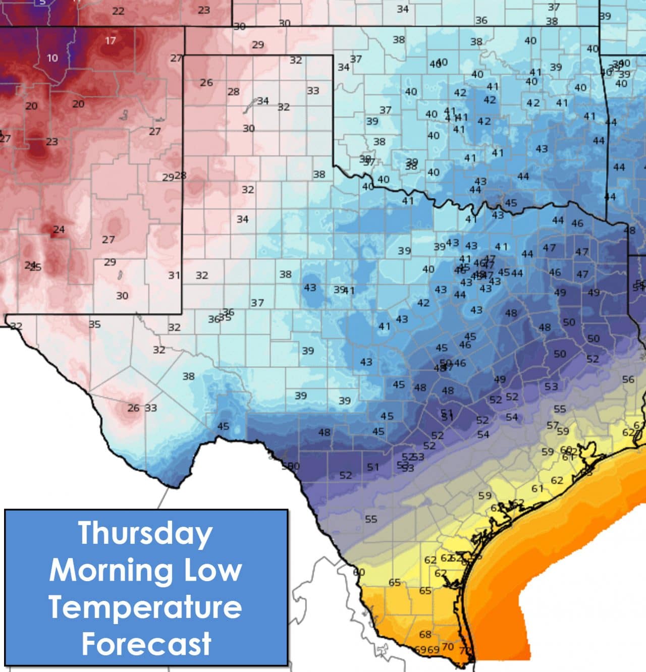
Thursday Morning is going to be cold across the northwest half of Texas. Parts of the Texas Panhandle and West Texas will bottom out in the 20s. Low to mid 30s are expected across the Caprock and Permian Basin with upper 30s in Northwest Texas, western North Texas, the Big Country, and Concho Valley. Those with agricultural interests should be prepared for a frost or even freeze. For more detailed temperature information please visit the National Weather Service at www.weather.gov. North Texas, including the D/FW Metroplex, will be in the low 40s. Mid to upper 40s will be the morning temperatures across Northeast Texas and Central Texas. Those right along the coast into South Texas will be in the 60s.


0 Comments