
We’re starting out with locally dense fog across parts of Central Texas and Southeast Texas. Compared to Monday and Tuesday mornings the fog is much less widespread. Like the past two days we expect any fog to burn off by mid to late morning. Another change for this morning is increasing dewpoint values and moisture. 60+ degree dewpoints have spread north to the Red River Valley this morning ahead of our next storm system. Seeing as the air temperature can’t fall below the dewpoint most folks are starting out warmer today with overcast skies. Moisture advection will continue today before we see rain chances ramp up tonight.
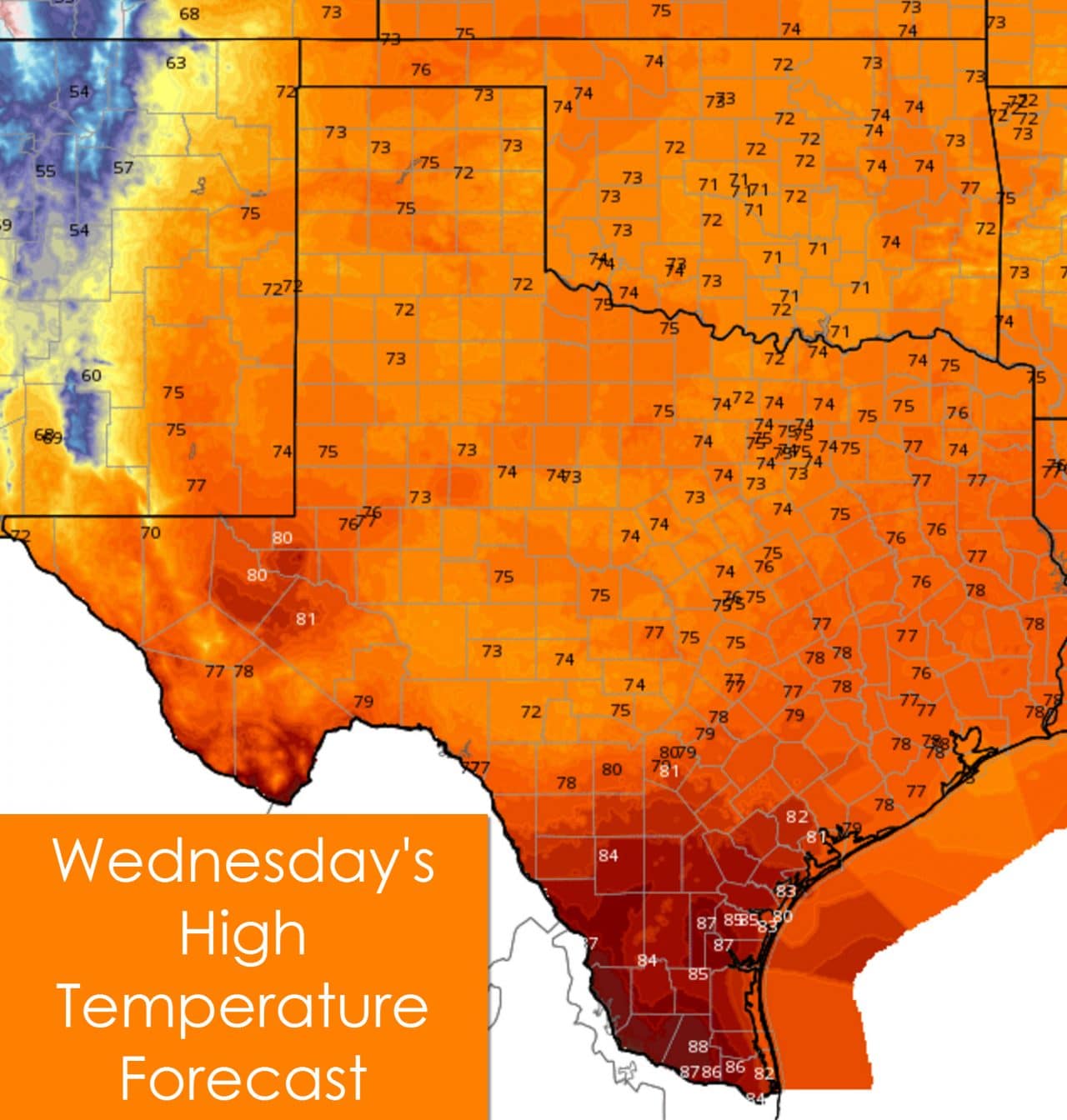
The warmest temperatures this afternoon will be located in the Rio Grande Valley with upper 80s anticipated. Increasing cloud cover will help keep temperatures in the 70s across the rest of Texas. Keep in mind that we are now in November – so 70s are actually considered a bit on the warmer side for some locations. Yeah, we’ve reached that point as we continue into the fall.

Low temperatures tonight into Thursday morning will be much warmer across the eastern two-thirds of Texas. Moisture return combined with cloud cover will keep temperatures from falling much tonight. Low temperatures in the 60s to 70s are expected across the eastern two-thirds of Texas. Temperatures across the Panhandle, West Texas, and Permian Basin will initially be warm tonight. A dryline/cold front will move east overnight allowing temperatures to fall by sunrise into the 40s.
Chance of rain/storms Tonight
Rain chances increase notably tonight as a powerful shortwave trough approaches from the west. Scattered thunderstorms are expected across the Texas Panhandle, South Plains, Rolling Plains, eastern Permian Basin, Southwest Texas, Concho Valley, Big Country, Northwest Texas, North Texas, and Central Texas generally along and west of Interstate 35.
Numerous thunderstorms are expected during the day Thursday across Northeast Texas, North Texas, Central Texas, into Hill Country. Scattered showers and thunderstorms are probable across the Concho Valley, Big Country, Brazos Valley, Southeast Texas, and East Texas. The highest rain chances on Thursday Night will be across Northeast Texas, East Texas, the Brazos Valley, Central Texas, South-Central Texas, and Southwest Texas. Scattered activity is also expected in Southeast Texas, North Texas, and eastern portions of the Big Country and Concho Valley.
Rain chances for Friday shift south into the Rio Grande Valley, Deep South Texas, South-Central Texas, Southeast Texas, and East Texas. Isolated showers will remain possible across North Texas and Northeast Texas. Wrap-around moisture behind the upper level trough may actually help increase rain chances again in the Big Country, Concho Valley, North Texas, Central Texas, and Northeast Texas in addition to areas further south. This activity would likely be lighter than what we see on Thursday. The same possibility exists for Saturday but I would prefer to get a day closer before getting too detailed with Saturday’s forecast.
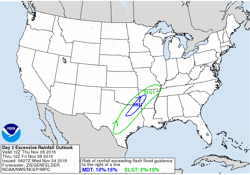
Flash Flood Outlook for Thursday & Thursday Night
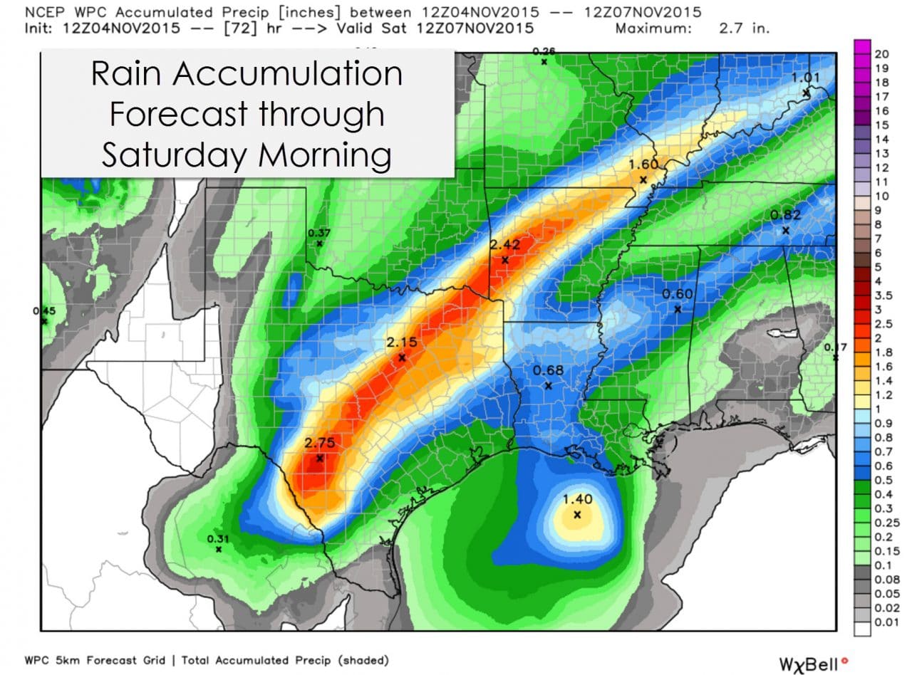
The rain accumulation forecast through Saturday morning is comparatively less than the past two events we’ve dealt with. That isn’t saying much though considering some locations picked up 20 inches of rain. Widespread rain accumulations of half an inch to one and a half inches are expected for the eastern two-thirds of Texas through Saturday morning. A band of heavier rain is expected to set up somewhere over Southwest Texas, the Hill Country, North Texas, and Northeast Texas where up to three inches of rain may fall. Saturated soil conditions mean the ground can’t take much water. Anyone who sees over an inch of rain (especially if it falls in an hour or two) could experience flash flooding. The Weather Prediction Center highlights the flash flood potential in their flash flood outlook for Thursday (shown above).
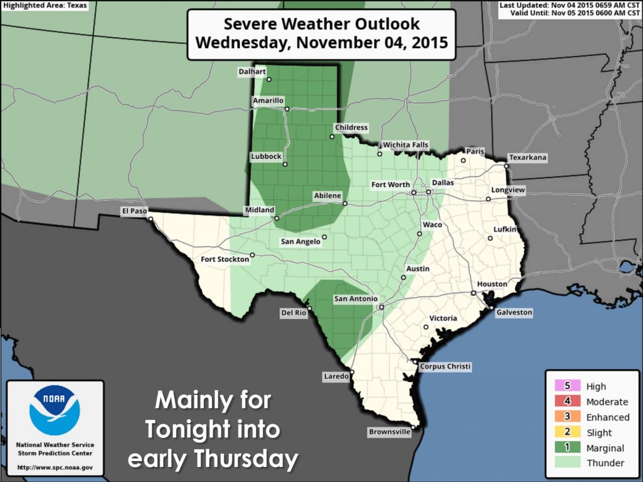
The dynamic nature of the upcoming storm system means severe thunderstorms will be a possibility. A category 1/marginal risk is in effect late tonight into the predawn hours on Thursday for the Texas Panhandle, South Plains, Rolling Plains, and parts of the Big Country. Southwest Texas is also in a marginal risk overnight. The stronger storms tonight will be capable of producing hail and localized damaging winds. While not zero I really don’t think we’ll have much of a tornado threat overnight.
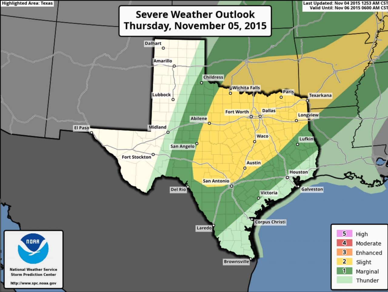
Severe thunderstorms could be an issue on Thursday. A large category 2/possible risk is in effect to the eastern sections of the Concho Valley, Big Country, Northwest Texas, North Texas, Central Texas, the Hill Country, the northwest half of the Brazos Valley, portions of East Texas, and Northeast Texas. A category 1/marginal risk includes the remainder of the Concho Valley, Big Country, Northwest Texas, Southeast Texas, and South Texas. The primary severe weather threat on Thursday will likely be in the form of damaging wind gusts. A few tornadoes are also expected in the category 2 risk area. Hail will be possible but due to the convective mode (linear) it shouldn’t become too much of an issue. We’ll do a more detailed blog post on the severe weather potential later this morning to publish around lunch time.


0 Comments