
We’ll enjoy one last day of quiet weather before Mother Nature shakes things up. A risk of severe thunderstorms, heavy rain, and localized flash flooding will make a return on Friday. If you want to get technical the rain chances ramp up tonight. Before we deal with all that mess lets talk about what you can expect for your weather today.
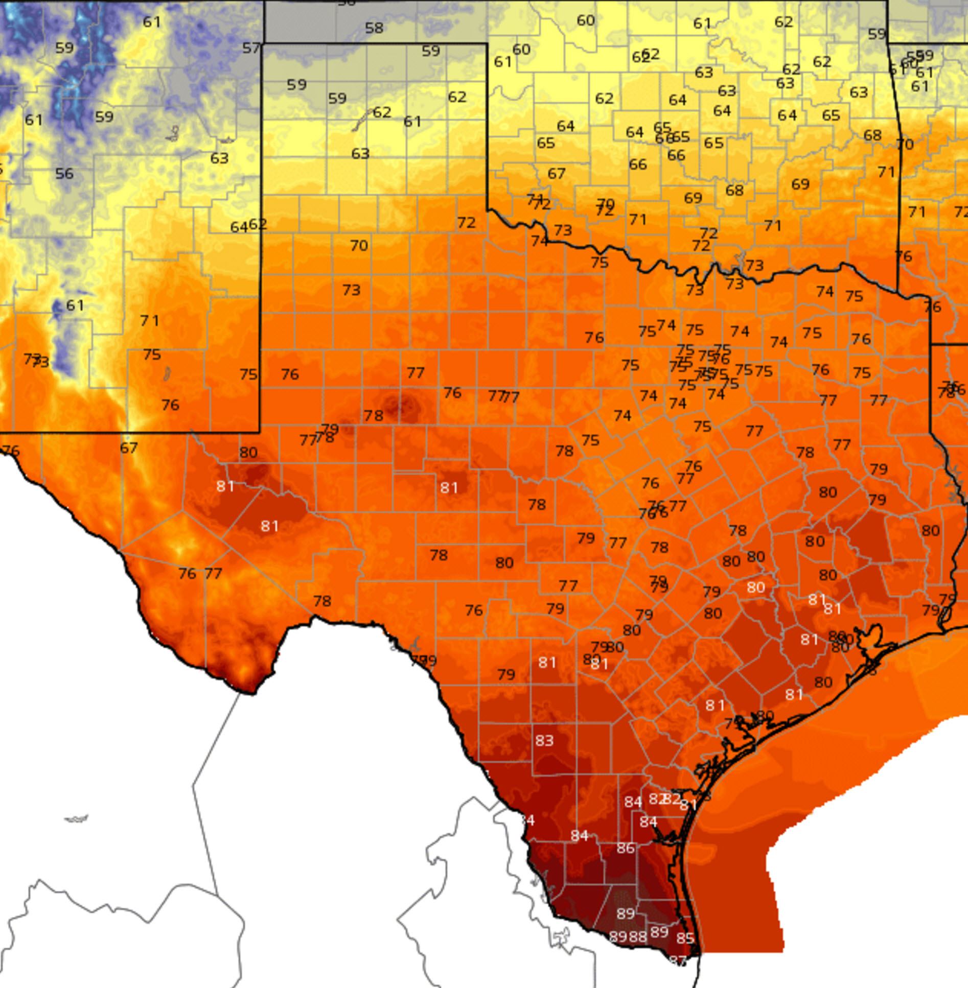
Temperatures this afternoon will top out around 90 degrees across the Rio Grande Valley. Contrast that to the upper 50s in the northern Texas Panhandle. I personally enjoy seeing how much of a temperature contrast we can get across Texas during the cooler months. Folks in the middle of the two ‘extremes’ will enjoy comfortable temperatures with 70s to low 80s. Cloud cover will be increasing along with moisture values today. You should be able to notice the change as we head into an active weather pattern.
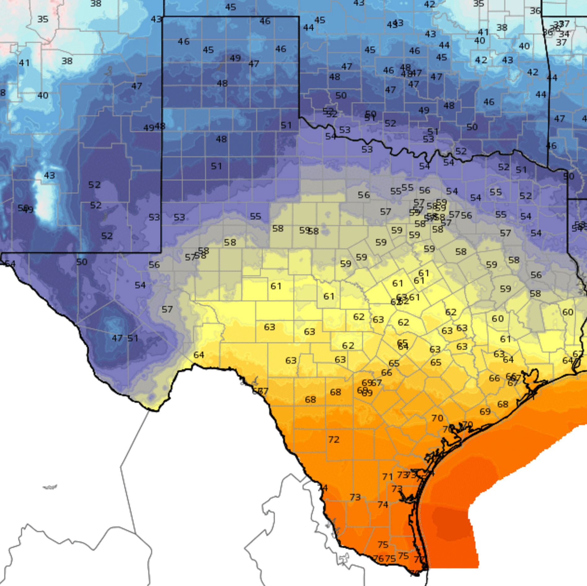
Tonight’s low temperature forecast
Low temperatures tonight will also display quite a spread with mid 40s in the Texas Panhandle all the way up to the mid 70s in the Rio Grande Valley. You’ll really be able to notice moisture return from south to north tonight as the low level jet cranks up. The increased moisture values will cause temperatures to rise overnight across parts of Texas. Folks in the Rio Grande Valley won’t get below 73-75 degrees with very rich tropical moisture flowing in off the Gulf of Mexico. Keep in mind these low temperatures may occur at midnight with slightly rising temperatures as moisture streams north.

Chance for rain/storms tonight
In conjunction with increasing moisture we’ll also see a rapid onset of upper level lift tonight. Scattered showers and thunderstorms are forecast across Far West Texas, the Permian Basin, Big Country, Concho Valley, Northwest Texas, West Texas, and the Texas Panhandle.
By Friday widespread to numerous showers and thunderstorms are expected across the Texas Panhandle, West Texas, Permain Basin, Concho Valley, Northwest Texas, Big Country, North Texas, Central Texas, Hill Country, Southwest Texas, South Texas, into the Rio Grande Valley. Activity during the day will be more isolated east of Interstate 45. By Saturday Night the heaviest rain and thunderstorms will be located across Northwest Texas, the Big Country, Concho Valley, North Texas, Northeast Texas, East Texas, Southeast Texas, South Texas, Central Texas, and the Brazos Valley.
Unlike the weather system last weekend the current system is going to be in a hurry east. On Saturday rain chances west of Interstate 35 will diminish during the early morning hours. By lunchtime the highest rain chances will be along and east of Interstate 35 with rain and storms still expected across Northeast Texas and East Texas. By Trick-or-Treat time we should only have isolated activity along Interstate 35 with most activity moving out of far Northeast and East Texas. The ground will still be wet but I’m hopeful most of Texas will be able to get the festivities in Saturday evening without too many issues.
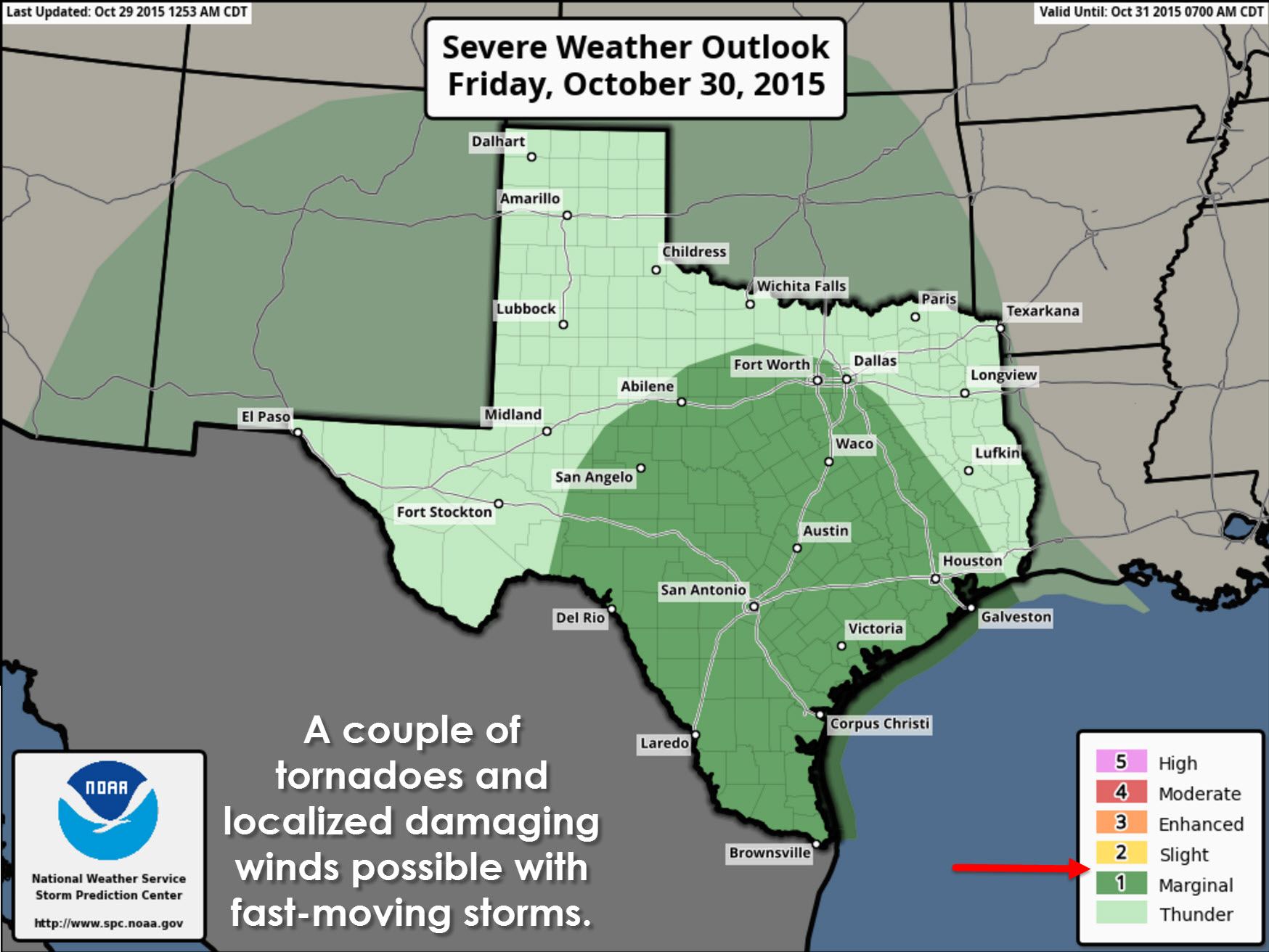
A marginal risk of severe weather is in place for the Big Country, Concho Valley, Hill Country, Southwest Texas, South Texas, the Rio Grande Valley, Central Texas, parts of North Texas, and Southeast Texas. The severe weather setup on Friday and Friday Night will involve very strong wind shear but low instablity amounts. This fall/winter severe weather setup will involve fast storm motions and low-topped convection. You generally don’t need the atmosphere to become too unstable to support rotating thunderstorms. However widespread rain and clouds are expected to keep instablity values very low and thus the severe weather threat limited in scope. Should it become more apparent that an area of higher instablity will develop then the severe weather threat will increase along with an outlook upgrade. With very strong wind shear in place we will have to watch for a tornado threat during the day on Friday and even into the late night hours on Friday. At this time the most likely area for a tornado threat is from the Hill Country and Central Texas south. It all depends on how far north a warm front and associated instablity axis can push. We’ll definitely be talking more about this threat in later updates and potential video briefings.

Rainfall amounts will average 1 to 3 inches across the eastern two-thirds of Texas. Isolated amounts over 4 inches will be possible. Compared to the event last weekend this will be a faster moving system with less rain. Soils remain saturated and thus it will be much easier to see localized flash flooding. We’ll have to watch for areas of localized flooding on Friday into the morning hours on Saturday.


0 Comments