
Interactive Weather Radar at TexasStormChasers.com/Radar
Most of the forecast focus is on the potential for severe thunderstorms later today and into the late night hours tonight. While we will discuss that potential in detail lets get through the temperature and Thanksgiving Day forecast first. High temperatures will vary a bit over the next five days as a couple weak cool fronts move south. They won’t really cool temperatures off but they will bring reinforcing shots of drier air and lower humidity. Highs will range from the upper 50s to the middle 80s; although Today, Thanksgiving, and Saturday will mainly be in the 60s, 70s, to middle 80s. Overnight lows will range from the 30s to the 60s depending on which side of the cool front you’re on and if drier air has filtered into your location. Friday morning looks to be particularly cold in the Texas Panhandle with lows in the middle to upper 20s. Wednesday Night through Thanksgiving Day look dry.
Scattered light showers and a storm or two will be possible Thanksgiving Night through Friday. Rain totals look to be very light with that activity, but most folks will remain dry. A strong storm system looks to arrive in the Sunday-Monday timeframe which could bring a big-time cold front and another round of storms. Thanksgiving and Friday both look good weather-wise in Texas.
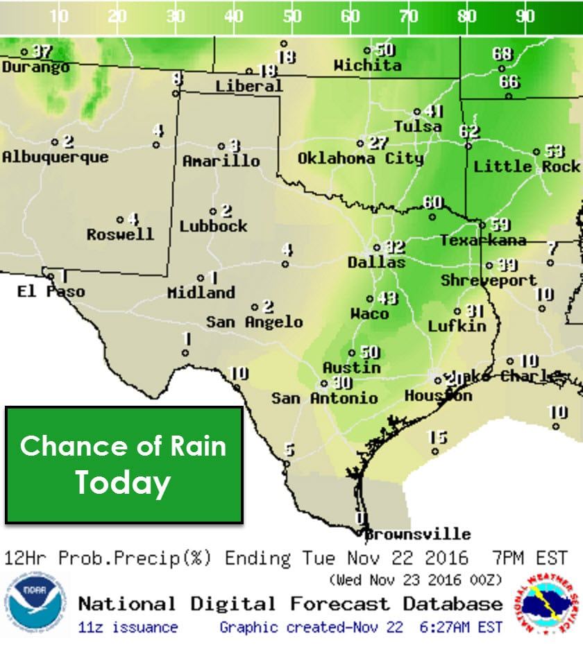
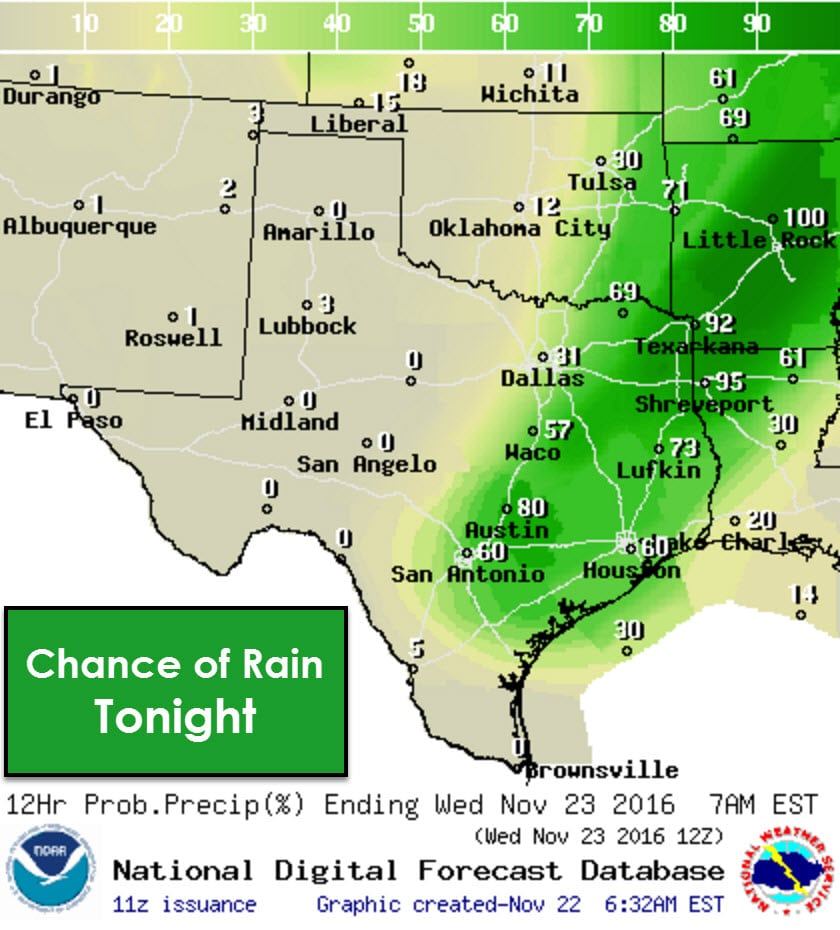
Now that the extended forecast has been taken care of lets chat about the weather forecast for today, tonight, into Wednesday. We’re starting off the morning with patchy mist and fog in some locations. You’ll notice south winds becoming more gusty as we continue into the daytime hours. A dryline is located from near Quanah to Aspermont to Fort Stockton. Winds behind the dryline are out of the west and will become gusty this afternoon. The dryline and a cool front will move east into western North Texas by this afternoon. It should set up near Interstate 35 by the late afternoon. A capping inversion will prevent thunderstorm development until the late afternoon/early evening hours. Scattered showers and a few weak storms are possible east of the dryline through the day, but this activity will not be severe. The real show should not begin until after 4-5 PM based on the current high resolution model data. Discrete thunderstorm development is possible after 4-5 PM in eastern sections of North Texas and East Texas. Thunderstorm coverage will increase by 8-9 PM along Interstate 35 in North Texas, Central Texas, and east into Northeast and East Texas. Some storms may be severe and we’ll discuss that in detail below. As the cool front moves south/east tonight into Wednesday precipitation chances will end north of it. A fairly decent line of storms should accompany the front by late tonight and those will continue into Wednesday as the front moves into the Brazos Valley and Southeast Texas.
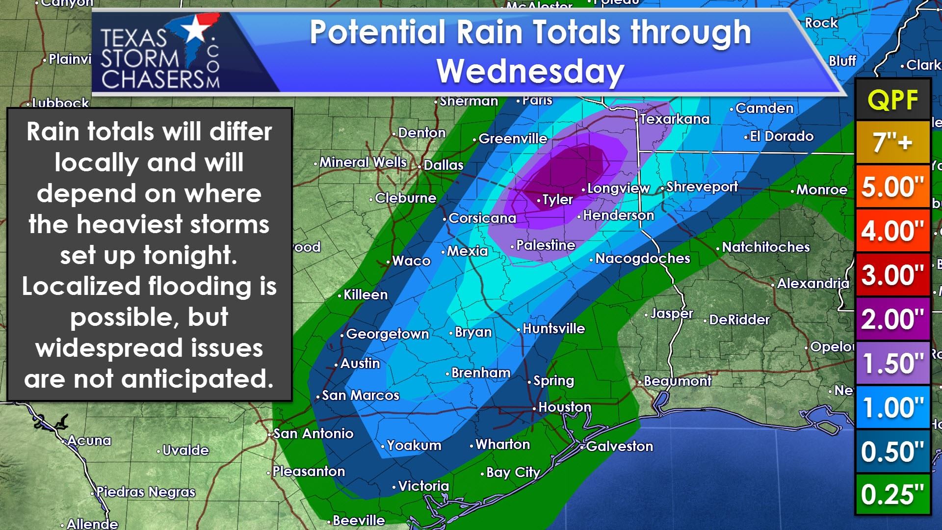
A quick 1 to 2 inches of rain is likely tonight where the heaviest storms set up. Some training is possible and that is where rainfall amounts may be locally higher. Widespread flash flooding is not likely since we haven’t had widespread, heavy rains lately. Localized flooding will be possible tonight into Wednesday morning where heavy storms move over the same areas. Rain totals should be highest over Northeast Texas southwest into the Brazos Valley.
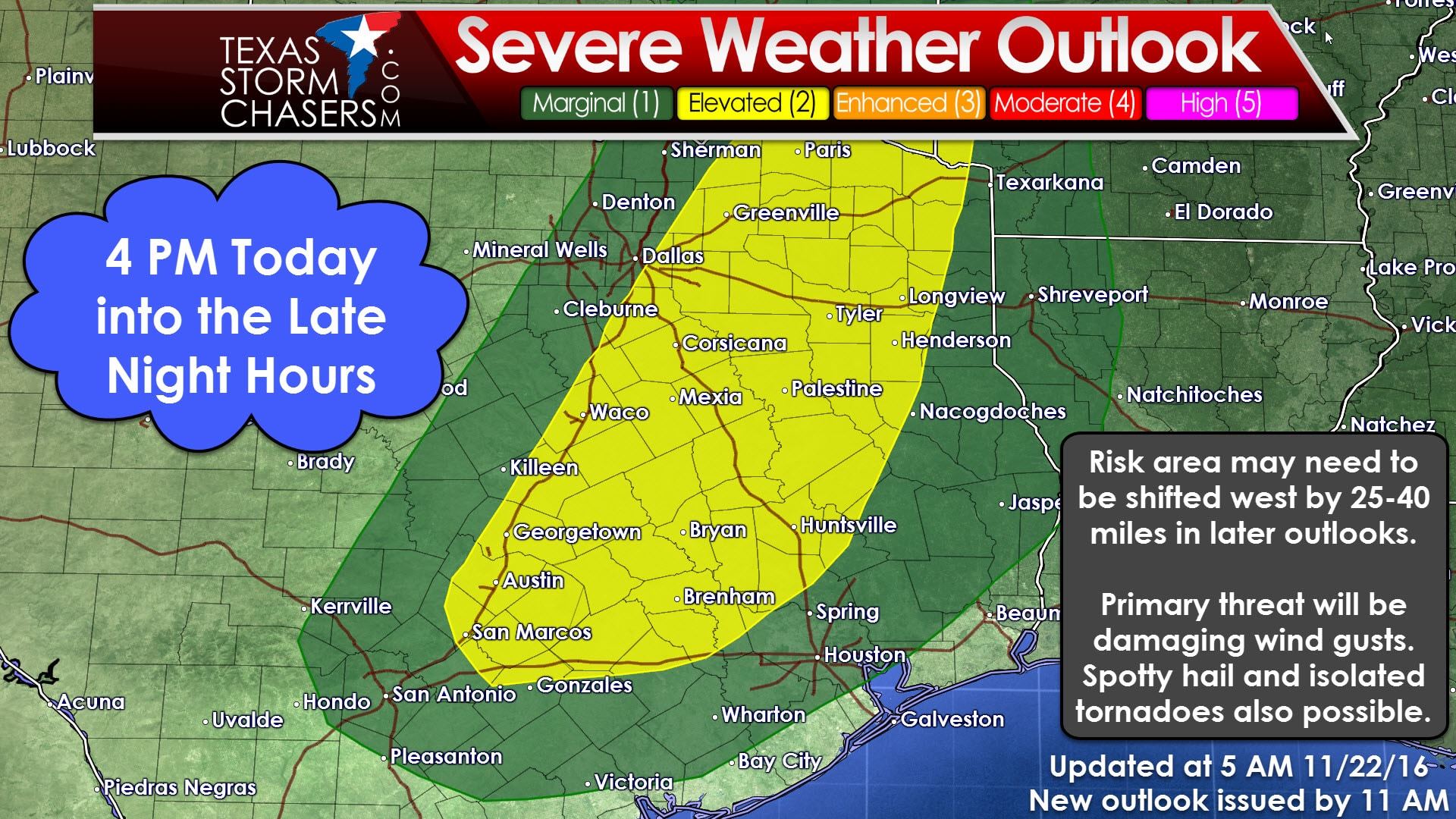
Now onto the severe weather potential. The Storm Prediction Center has expanded the standard, category 2 risk compared to yesterday’s outlook. It now runs roughly along and east of a Bonham-Dallas-McGregor-Wimberly line. It includes the eastern half of North Texas, the eastern half of Central Texas, the Brazos Valley extending northeast into East Texas and Northeast Texas. A category 1, marginal risk includes South-Central Texas, Southeast Texas, and runs about 40-50 miles west of where the category 2 risk starts. The primary hazard with the linear storms this evening and tonight will be localized damaging wind gusts up to 65 MPH and a few hail stones up to the size of quarters. Not all storms will be severe tonight. A more conditional potential is for discrete supercells to form well ahead of the dryline in East/Northeast Texas by the late afternoon/early evening hours. Only a few of these supercells would occur if they were to develop at all. If we do have discrete, intense storms form they would have the potential to produce hail up to the size of half-dollars, localized wind gusts up to 70 MPH, and a low-end tornado threat. We’ll be monitoring the upper level storm system’s track and speed closely today. If it slows down a bit the dryline would probably set up a tad further west than this outlook indicates. That would bring more of the storm threat closer to Interstate 35 in North Texas. That’s something that would require a westward extension of the severe weather outlook probabilities.
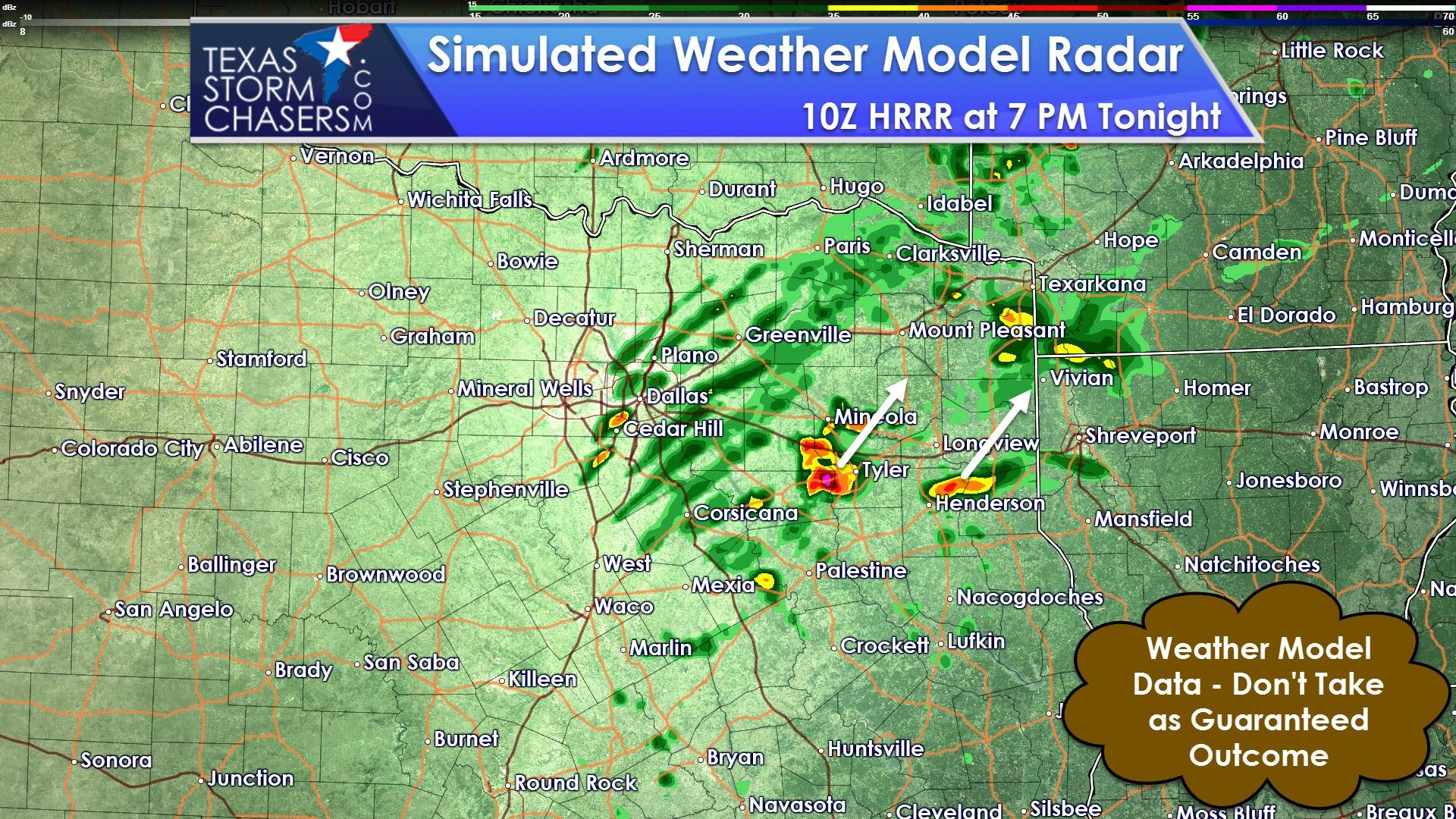
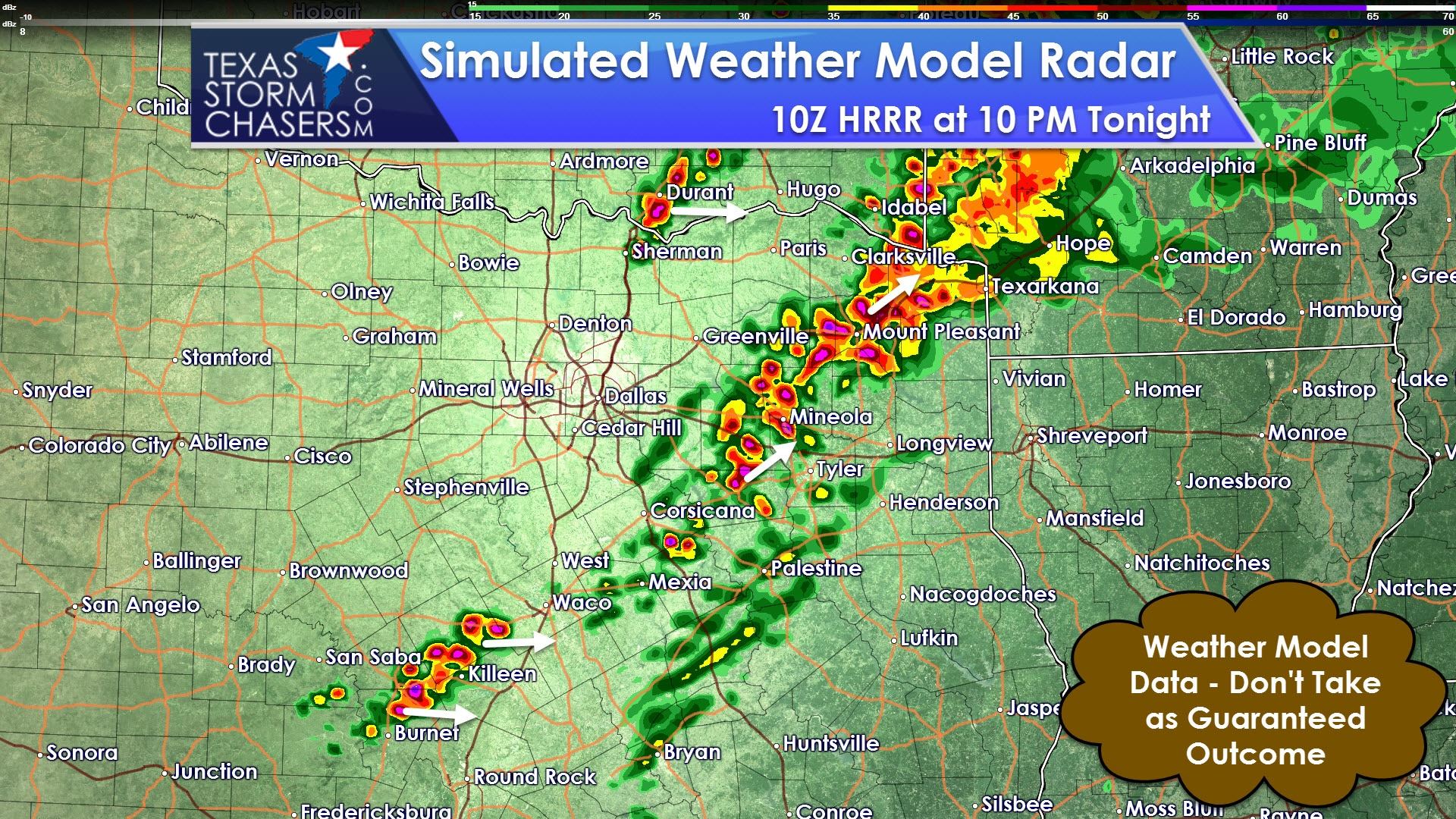
These two simulated radar graphics come from the 4 AM run of the hourly run High Resolution Rapid Refresh (HRRR) model. We note it does develop a few discrete storms in East Texas by late afternoon/early evening. Those storms would move northeast and would have the highest potential of producing a tornado. That scenario is far from a guarantee and those storms might not even develop at all. We could have to wait for the cool front to develop a squall line later in the evening, but its something worth mentioning. By 10 PM the same model has a few line segments underway in Northeast Texas, plus storms firing up on the cool front/dryline back towards Interstate 35. Once again if things slow down a bit all of this could happen 25-40 miles further west. We’ll be posting updates throughout the day and keeping folks updated. I’ll work to publish an updated severe weather outlook around 11 AM with our latest thoughts. It should include a video briefing as well.


0 Comments