
Well, that was an interesting night. National Weather Service crews will survey any suspect damage today to determine if we had any tornadoes occur from last evening’s storms. I know the NWS in San Antonio will be out around Hondo later this morning, where damage was reported. Otherwise, much of last evening’s problems were caused by hail.
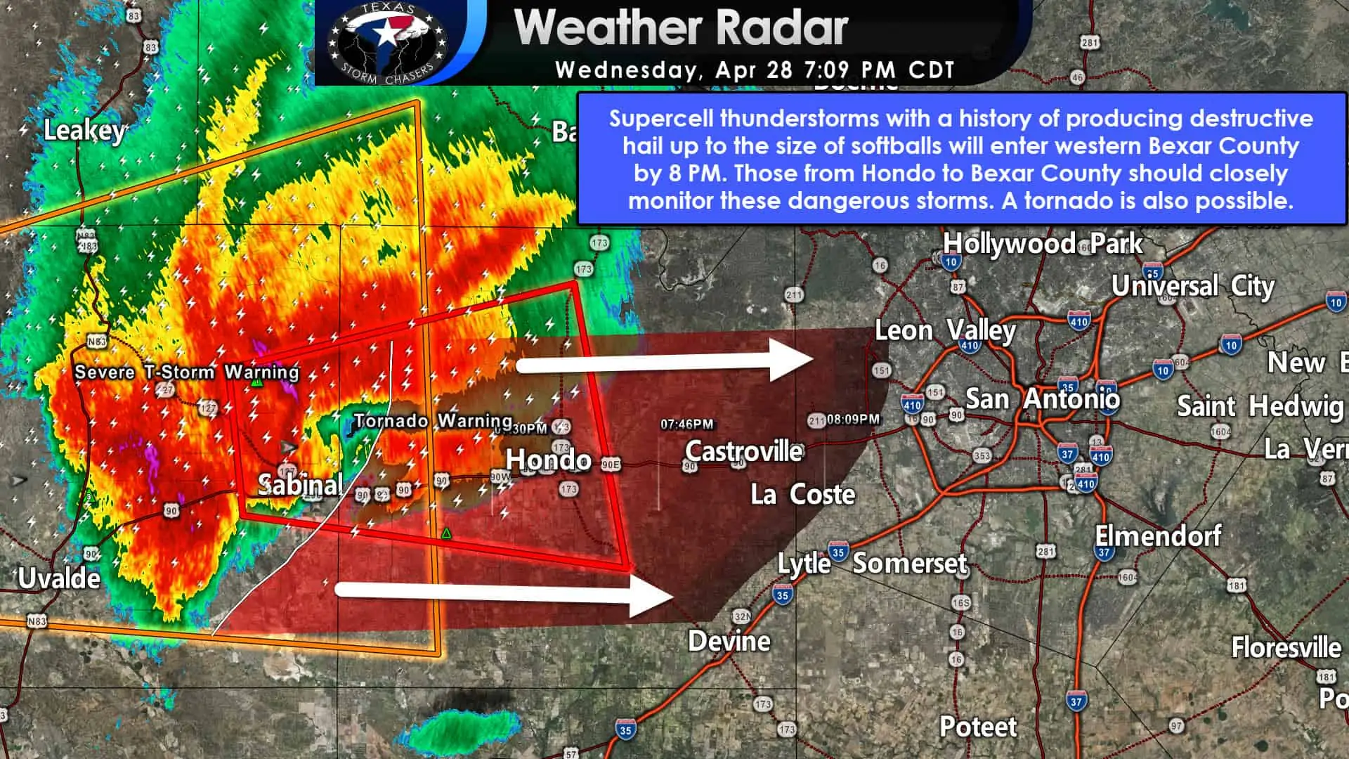
Image during last night’s severe weather
I think it is safe to say when I wrote my blog at 5 AM yesterday, and I was not expecting a billion-dollar hail day in Texas and Oklahoma. Unfourtaintiely, that’s what we got with baseball size hail falling in parts of San Antonio, D/FW, and up north in Norman (Oklahoma). It was not a good night for Interstate 35.
Fortunately, the threat for severe thunderstorms has mostly diminished overnight. A rogue storm with gusty winds snd small hail cannot be ruled out in East Texas this morning. However, I think we’re mostly done with intense storms for today and tonight.
Don’t get me wrong; we’re going to have plenty of showers and thunderstorms continue today across several regions in Texas. They’ll be ‘behaved storms’ versus the ‘punch holes in your roof’ kind of storms. With a big-time majority of Texas in or edging into drought, we are lucky to have rain in the forecast for the next several days. It won’t rain constantly, nor will everyone actually see rain today.

Forecast precipitation chances through the weekend. It will not rain constantly but will be in waves.
I previously expected rain to end in time for the weekend. That will not be the case as our nearly-stationary upper-level system wants to sit around through Saturday before finally getting its big behind out of our hair on Sunday. Well, y’alls hair at least. They don’t call me ‘chief baldy’ for no reason.
While some folks will have outdoor plans disrupted this weekend, we really need the rain. Nobody who lived through the 2011 drought wants anything coming close to an encore.

Saturday’s severe weather outlook from the Storm Prediction Center
After a marginal threat this morning, severe thunderstorms are not likely to occur in Texas until Saturday. We’ll start to see the atmosphere become more ‘juiced up’ in the instability/wind shear department Saturday Afternoon and Saturday Night.
Overnight weather model data indicates the highest (relative) potential for a few severe storms in Brazos Valley and East Texas. The Storm Prediction Center has highlighted those two regions within Saturday’s severe weather outlook. We’ll refine the forecast as we get closer to Saturday.

Expected rain totals through Sunday morning. Some isolated amounts may be double what is shown on the graphic.
Rain chances will finally end from west to east during the day Sunday. If the upper-level low decides to stop off at Buccees on its way out of town, we may have scattered showers continue in East Texas until Sunday Night.

Severe weather outlook for Monday, May 3rd
We’ll get a brief break before the threat for a few severe storms returns Monday in North and Northeast Texas. The Storm Prediction Center has highlighted that potential in their extended-range outlook. We’ll deal with Monday (May 3) after we get past Saturday.
0 Comments