
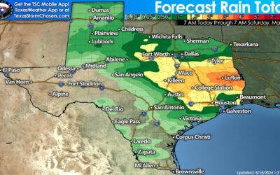
The Atlantic Basin’s tropical mischief scale went from zero to sixty faster than a Ferrari this week. There are three systems of interest this evening. Tropical Depression #13, Tropical Depression #14, and a tropical wave still exiting Africa. We’re not going to worry about TD #13 or the African wave much right now. However, we do note that TD #13 could impact Florida and the eastern Gulf of Mexico next week. Our focus for the western Gulf of Mexico will be on Tropical Depression #14 – nicknamed TD14 for simplicity’s sake.

Visible satellite image of disorganized showers and thunderstorms associated with Tropical Depression #14
I believe TD14 is still in the infancy stages of development today. Hurricane hunters from the United States Air Force investigating this afternoon found a broad area of low pressure south of most of the convection shown in the satellite imagery above. We’ll see if the system becomes more organized tonight. Wherever the strongest storms develop may be where a more defined low-level circulation materializes. We’ll have to keep an eye out for a center relocation overnight. If it reforms farther north or south, there would be implications to the longer-term track forecast. As it stands now, the forecast track is one filled with uncertainty, especially from Sunday through Tuesday.

The current center of TD14 remains diffuse, so there’s a chance it may reform farther north or south overnight. Regardless, more land interaction generally means a weaker system. If the system can stay north of Honduras tomorrow, we’d likely see it enter an intensification phase. Gradual organization is expected overnight and on Friday when TD14 likely graduates to ‘tropical storm’ status. Assuming TD14 isn’t severely disrupted by land tonight, we should see a strengthening tropical storm Friday and Saturday. Landfall is expected Saturday night on the Yucatan Peninsula before the storm moves to the north/northwest into the southern Gulf of Mexico.
Let me be clear that we’re still in the initial stages of development with this system. The forecast track and intensity will likely change. There are far more uncertainties versus facts at this juncture. Keeping all of that in mind, the latest forecast from the National Hurricane Center has a tropical storm approaching the Texas or Lousiana coast by the afternoon hours Tuesday. The cone of uncertainty runs from Corpus Christi to the mouth of the Mississippi River. Even outside the cone, I’d encourage folks down to the Mexico border to keep eyes out for new forecasts through early next week. While not shown here, a hurricane is likely to impact the eastern Gulf of Mexico around the same time.
Hot water is jet fuel to tropical cyclones, but wind shear is their kryptonite.

Sea surface temperatures this morning in celsius
Sea surface temperatures across the Gulf of Mexico and the Caribbean are hot. Temperatures over 30 degrees celsius might as well be jet fuel for tropical cyclones. Like dry tinder in a wildfire, these warm water temperatures can result in big-time tropical mischief. However, there is expected to be some wind shear over the northern Gulf of Mexico on Monday and Tuesday. If the wind shear materializes, that could be enough to keep a tropical system steady-state, or even induce some weakening before it makes landfall. However, if that wind shear ends up being farther north, we would have to increase the intensity forecast of this system – significantly. For now, it appears this system will be a strong tropical storm at landfall with gusty winds and some storm surge – in addition to heavy rain.
We’re just getting started – answers will come, but not today…
We’re still five days out from potential tropical impacts to the US Gulf Coast, and the system we’re discussing is still in its infancy. Let’s see how well it organizes tonight and what the upcoming weather model suite shows. For what its worth – most models didn’t even have this system developing. Forecasters at the National Hurricane Center get a cookie for also indicating this system’s potential development a few days ago. Let this be a reminder that weather models aren’t the one real tell-all. Experience and an understanding of tropical meteorology still play essential roles. Live with the weather models – die with the weather models.

Forecast for Tropical Depression #13 – not to be confused with Tropical Depression #14. Yeah, it’s 2020.
Always use the official forecast from the National Hurricane Center for your planning and decisions. At this point, we’re still watching and waiting. Hopefully, we’ll have more answers by this time tomorrow. Either way, it appears quite possible that two tropical cyclones will directly impact the United States Gulf Coast next week. It remains too soon to tell if we’ll also have to deal with Tropical Depression #14 in the western Gulf of Mexico late next week, but for now, that one looks like a Florida problem. Take time over the next few days to ensure your hurricane plans are up to date.
0 Comments