
It has been a loud night for Texas’s Central, South-Central, and Southern portions. Thunderstorms have returned to the state, and they put on a show. Several inches of rain fell across parts of the San Antonio metro overnight, flooding the International Airport. Several low-water crossings across Central/South-Central Texas are closed. This first round begins what will be a week-long endeavor of precipitation chances across a majority of Texas.
Dense freezing fog coated the Panhandle and West Texas in a thin layer of ice overnight. As temperatures rise above freezing this afternoon, those accumulations will melt. The same goes for Texoma, North Texas, and the Ark-La-Tex folks. Temperatures should rise above freezing in those regions, at least south of the Red River. Any rain will ‘be rain’, and ice should be melting pretty quickly.
Heavy Rain, Flooding, Rowdy Storms… Wellzy!
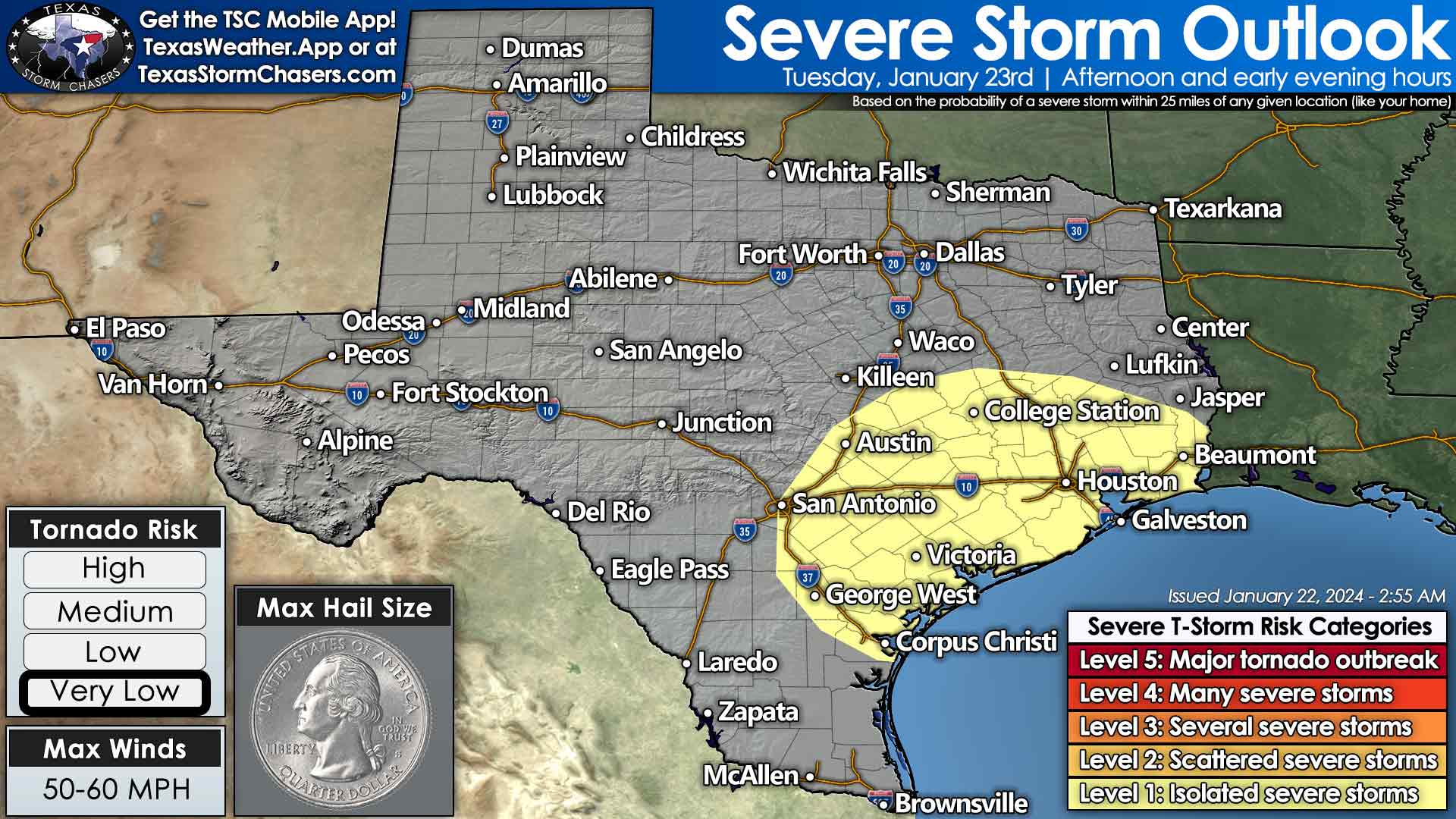
Texas severe weather outlook for Tuesday, January 23rd. During the afternoon, a low threat for severe storms may develop in the Coastal Bend, Coastal Plains, Brazos Valley, and Southeast Texas. This would include Corpus Christi, San Antonio, Austin, College Station, Houston, Victoria, Galveston, and Beaumont. The main hazard would be localized damaging wind gusts and perhaps a brief tornado.
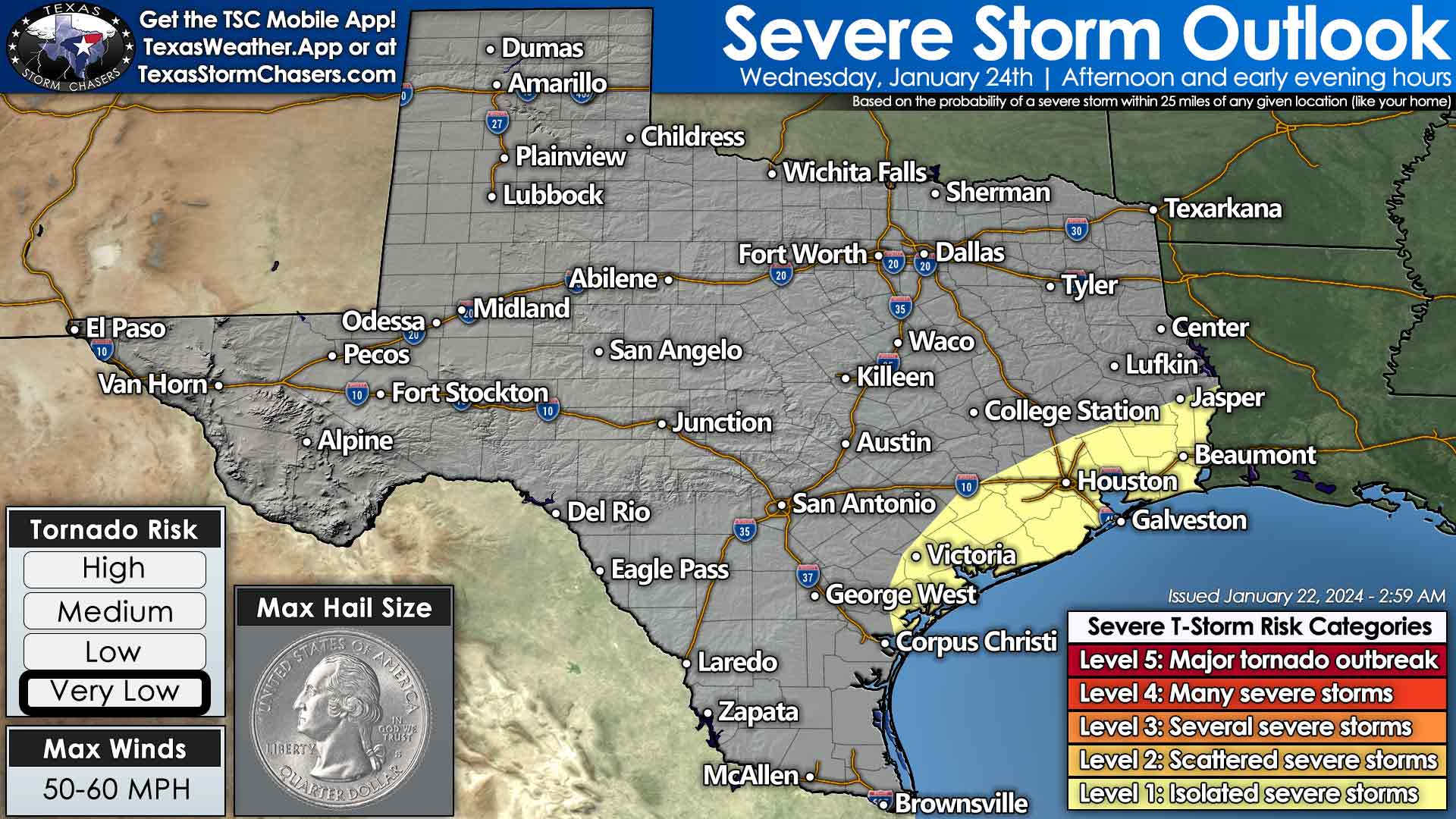
A low risk for severe storms may develop again Wednesday afternoon in proximity of the middle and upper Texas Gulf Coast. Generally, from Corpus Christi to Victoria to Houston, Galveston, Beaumont, and Jasper. Gusty thunderstorm winds would be the main issue.
Numerous showers and thunderstorms are expected this afternoon across the eastern half of Texas. More showers and storms are likely tonight into Tuesday across nearly all of Texas. Severe storms aren’t likely today. Stronger storms may produce gusty winds, small hail, and frequent lightning. Heavy rain will be the primary hazard, with localized flooding a possibility. As multiple rounds of precipitation continue through mid-week, more flooding may occur across the eastern third to the eastern half of Texas. Several inches of rainfall will likely fall across the eastern half of Texas through the work-week.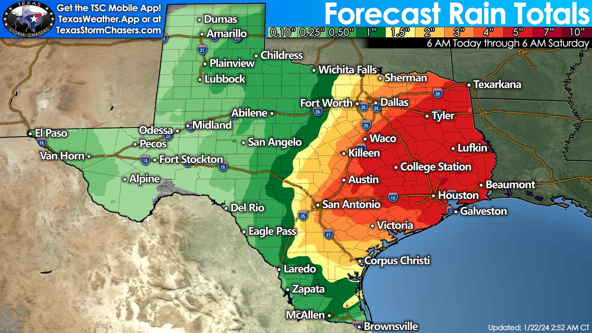
Thursday may be a down day for thunderstorm activity, but a cool front arriving on Friday may bring more chances for rain. We’ll firm up those details once longer-range weather model data agrees on the system’s timing. Unlike the last several fronts, this weekend’s cold front does not look to have an oversized attitude.
Keep up with our latest news! Grab the FREE Texas Storm Chasers Mobile App for your local weather forecast, interactive weather radars, live Texas weather coverage, and more!
Love the shirt!
Happiness is achieved when your aim and desires in life are determined. This is the right time to invest in CryptoCurrency still doubting the efficiency of my word? Give it a try and have the satisfaction you can obtain for yourself. I gave it a try and I can boldly stand and tell everyone you are the best when it’s come to trade. You can reach him out for a successful trading Shawn Harrison
Just missed Llano, we only received .04 of rain.
ValentinMarissa Sanchez
Eliana Garcia
We received a lot of rain here in New Braunfels (Gruene).
It started up about 1130 last night in northeast San Antonio, and stopped about 815. Nearly 9 hours of steady to heavy rainfall.
I got a solid 5” west of New Braunfels. Up shortly before midnight with a panicked dog from the thunder.
That’s Texas for you !
Bring. It. On!!!!
Cheryl Davis Hall 3Gcdo2ZEkVHUFcpLwmuEavSefGCoz2FPQ1
Looking forward to the rain ⭐️⭐️⭐️⭐️⭐️⭐️⭐️⭐️⭐️⭐️⭐️⭐️⭐️⭐️⭐️⭐️⭐️⭐️⭐️⭐️⭐️⭐️⭐️⭐️⭐️⭐️⭐️⭐️⭐️⭐️⭐️⭐️⭐️⭐️⭐️⭐️⭐️⭐️⭐️⭐️⭐️⭐️⭐️⭐️⭐️⭐️⭐️⭐️⭐️⭐️⭐️⭐️⭐️⭐️⭐️⭐️⭐️⭐️⭐️⭐️⭐️⭐️⭐️⭐️⭐️⭐️⭐️⭐️⭐️⭐️⭐️⭐️⭐️⭐️⭐️⭐️⭐️⭐️⭐️⭐️⭐️⭐️⭐️⭐️⭐️⭐️⭐️⭐️⭐️⭐️⭐️⭐️⭐️⭐️⭐️⭐️⭐️⭐️⭐️⭐️⭐️⭐️⭐️⭐️⭐️⭐️⭐️⭐️⭐️⭐️⭐️⭐️