
Unsettled weather is forecast to continue for much of Texas through Thursday. The last two days have shown what happens when you get heavy tropical downpours on urbanized areas. Houston and Austin both experienced several inches of rain in the period of 45-60 minutes. Flash flooding resulted, and more tropical downpours are forecast across parts of Texas today and again tomorrow. Where we see heavier rains fall, it will take a bit of time for all the water to drain out.
Hello again, Grace!
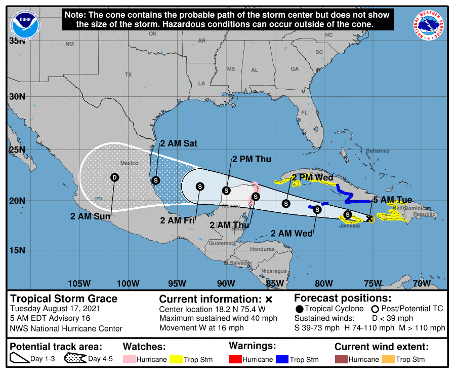
Real quick, let us talk about Tropical Storm Grace. It is located in the Caribbean this morning, and will be moving near Jamaica this afternoon. It could approach the Yucatan Peninsula, near Cancun, as a hurricane late tomorrow night. Weather model guidance is fairly strong agreement that Grace will remain several hundred miles south of Texas with a mainland Mexico landfall on Saturday. Increased tides are probable along the Texas coast (and are already underway thanks to Fred in the eastern Gulf yesterday). Thankfully, Grace doesn’t look like it’s going to be a problem for Texas. We’ll keep an eye on it, but it doesn’t look like I (baldy-in-chief) will have to do any long-form live coverage. (YAY!)
Another week, another round of summer rain.
Showers and thunderstorms are likely today across a large portion of Texas. It’ll simply be easier for me to describe who has the lowest chance of rain. The Texas Panhandle north of Interstate 40 and those from Eagle Pass south/southeast through Laredo and into the Rio Grande Valley have the lowest rain chances today. Everyone else has a chance of scattered to numerous showers and storms.
It won’t rain all day in any given location. Still, there is plenty of tropical moisture in place, along with a source of modest upper-level lift. That’s all it takes in August to generate tropical downpours.
What is true today will also be true tomorrow. Another wet day is expected across several regions of Texas. We’ll see rain chances decreasing across parts of West Texas and the Borderland – with the Rio Grande Valley also looking to stay mostly dry (and hot!).
Today’s simulated weather radar
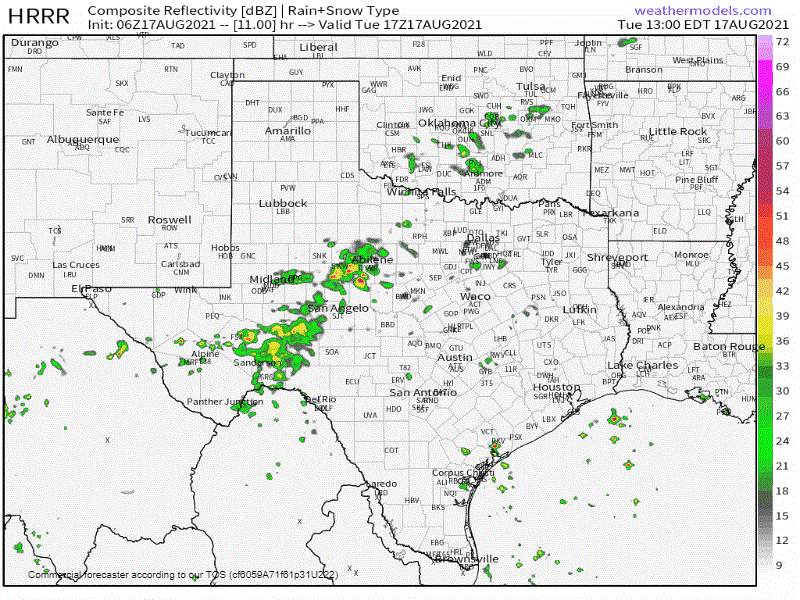
Showers and thunderstorms are already underway across parts of Texas this morning. Activity will continue through the day. Both coverage and intensity of storms will pick up during the peak of daytime heating. A few stronger storms with gusty winds and small hail are probable. Organized severe weather in the form of damaging hail, long-lived severe winds, and tornadoes are not expected today. We’re dealing with summer-time tropical moisture – not an organized severe thunderstorm event.
Most of today’s activity will be efficient in the rainfall department. Thunderstorms may produce one to three inches of rain in one hour. Brief flooding of roadways and quick rises on streams/creeks are likely where any heavier storms sit for a bit. Long-lived and widespread flooding are not likely today but don’t be the fool that has to get rescued after driving into a flooded roadway. It is not rocket science or meteorology, for that matter. Turn around, don’t drown (and flood out your vehicle).
After Thursday, we’ll start trending back toward a summer-time pattern. Scattered afternoon tropical downpours will shift closer to the coast, and inland regions will dry out. Temperatures will be on the increase this weekend into next week with lower rain chances.
You can keep an eye on the sky with our Texas interactive weather radar here on our website. Those using our free mobile app can click the ‘radar’ button on the bottom menu bar.
0 Comments