
Impactful weather is expected across several regions of Texas over the next two days. Everything from a significant winter storm with nearly a foot of snow to severe storms with damaging hail, strong winds, and a possible tornado threat are on the table. That doesn’t even mention the widespread rain and localized flooding potential. Like I said, we’ve got much to discuss across Texas. To keep things manageable, I will separate the hazards into sub-sections. We’ll talk about each threat in their respective categories.
Winter Storm & Snowstorm
A significant winter storm is expected across the Texas Panhandle, West Texas, and Northwest Texas tonight through Sunday evening. Some snow may also mix with rain across the northern Permian Basin, the Big Country, into Texoma and North Texas on Sunday. This has the potential to be a once-in-five to once-in-ten-year event with localized snow accumulations exceeding one foot. Uncertainties on specific snow totals include warm ground temperatures, initially modest surface temperatures near freezing, and snow’s heavy, wet nature.
Warm ground temperatures will try to reduce snowfall accumulations, but snow is expected to be quite heavy at times. That heavy snow will likely overwhelm the melting rate, allowing for significant wet snow accumulations. Weather models are showing convective elements and some instability – allowing for the possibility of thundersnow. Under the heaviest snow bands, accumulations of one to two inches of snow per hour are expected.
Strong north/northwest winds could sometimes exceed 30 to 35 MPH, resulting in low visibility. The wet nature of the snow may keep it from blowing around too much once it’s on the ground. Initially, roads may remain damp, but eventually, roads will turn into a slushy mess. Temperatures will fall below freezing across the Panhandle, West Texas, and Northwest Texas by Sunday night.
Any water, slush, or snow on roads will freeze into ice – meaning even if road conditions are manageable during the day Sunday, things will get nasty Sunday night and for the Monday morning commute. Exactly where the small bands of heavy snow/thundersnow set up won’t be something we can pin down until within a few hours of the event.
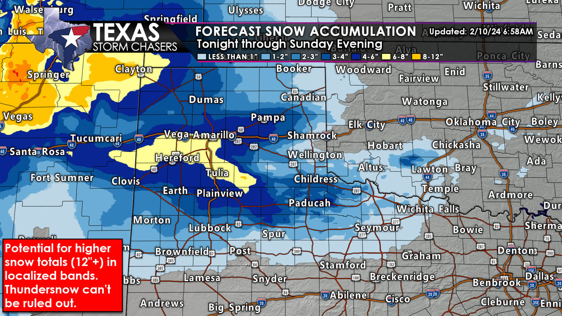
Regardless, we anticipate widespread five to ten-inch snowfall accumulations across the Texas Panhandle along and south of Interstate 40, south through the Rolling Plains, South Plains, West Texas, including Lubbock, and northeast through Childress and Quanah. Some locations may see over one foot of snow accumulation. The rain/snow line is expected to move south and east into the northern Permian Basin, the Big Country, Northwest Texas, Texoma, and perhaps even North Texas Sunday night. That means rain may mix with or change over to wet snow. Minor snow accumulations, mainly on grassy surfaces, are possible across Texoma and North Texas.
Surface temperatures will likely remain near or above freezing there, helping to prevent more significant issues. That being said, we’ll undoubtedly watch trends to ensure we don’t try to overperform.
We anticipate a high-impact snowstorm across parts of the Texas Panhandle, West Texas, on and off the Caprock, and into parts of Northwest Texas. Travel disruptions are expected, and the wet nature of the snow may result in some tree and powerline damage where snow accumulations exceed one foot. The Monday Morning commute will be severely impacted. Fortunately, we won’t have an arctic airmass behind the departing storm system. Temperatures should approach or rise above freezing Monday afternoon, helping to thaw out roads. Temperatures will fall below freezing again Monday night into Tuesday morning, refreezing any water or slush.
Severe Storms Tonight & Sunday Morning
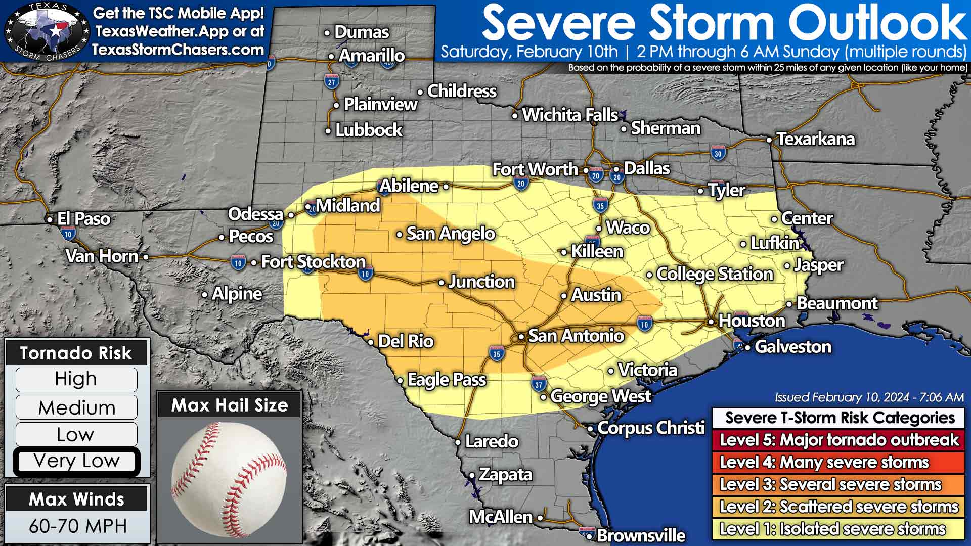
Numerous showers and thunderstorms are expected across the eastern half of Texas this morning and afternoon. Stronger storms will be capable of producing pocket-change-size hail. Some hail stones may exceed the size of quarters. Heavy rainfall, gusty winds, and frequent cloud-to-ground lightning are also expected. When thunder roars, go indoors! A brief lull may occur early this evening.
A more concerning severe thunderstorm threat is expected tonight through Sunday morning across the Concho Valley, Edwards Plateau, Hill Country, Central Texas, and South-Central Texas. Concern has increased regarding the potential for damaging hail up to the size of baseballs, damaging wind gusts, and the potential for a tornado. Thunderstorms are expected to develop around 11 PM to Midnight. A superceulluar storm mode is expected, with all modes of severe weather possible. Damaging hail will likely be the most prominent issue.
Storms will likely spread east into the regions mentioned above during the early morning hours on Sunday. During Sunday’s pre-dawn hours, impacts to the Interstate 35 corridor across Central Texas, the Hill Country, and into South-Central Texas (Waco, Belton, Round Rock, Georgetown, Austin, New Braunfels, and San Antonio) are possible. Severe weather will be a distinct possibility, and the overnight event timing increases my concern.
Storms may grow upscale into a squall line of thunderstorms that spread east into the Ark-La-Tex, East Texas, the Brazos Valley, and Southeast Texas during Sunday morning and early afternoon hours. The strongest storms would remain capable of producing large hail, damaging winds, and a tornado. Those storms should move east of Texas by early Sunday afternoon. We’ll need to watch for any new, isolated storms in Southeast Texas tomorrow afternoon – but that’s a lower-probability scenario for now.
Rainfall Totals
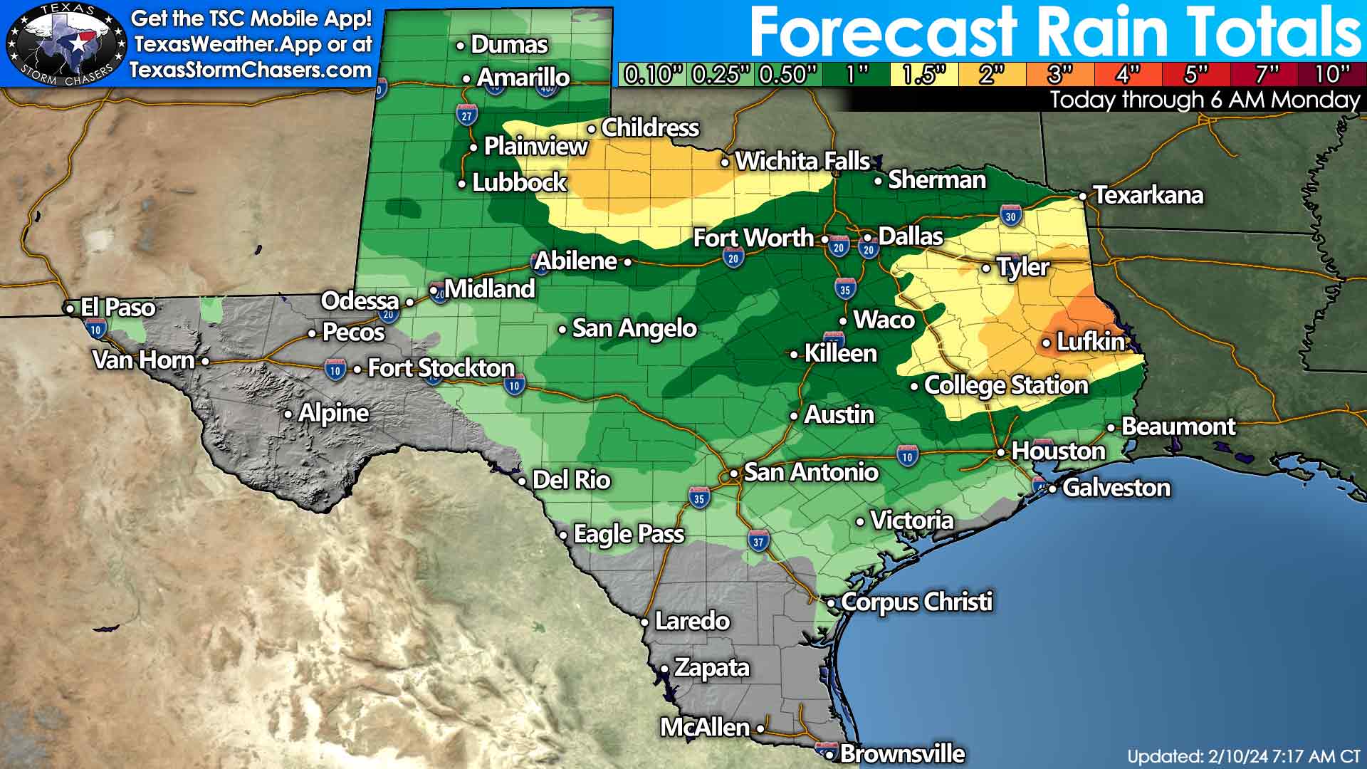
One to three inches of rain are expected today, tonight, and Sunday across the Ark-La-Tex, East Texas, the Piney Woods, and back west into the Brazos Valley. Localized flooding will be a threat, with creeks, streams, and watersheds rising. One to one-and-a-half inches of rain are possible across Texoma, North Texas, Central Texas, and Southeast Texas. Rain (or snow that melts after the fact) could be one to three inches across the southeastern Texas Panhandle, West-Central Texas, the Big Country, and Northwest Texas. Big Bend, Southwest Texas, South Texas, the Rio Grande Valley, and Rio Grande Plains generally miss out on appreciable precipitation.
Temperatures & Next Week’s Outlook
A cold front will bring a return to February weather to Texas on Sunday and into the early half of next week. It will be chilly Monday and Tuesday mornings across the northwestern half of Texas, especially where a snowpack is in place. However, afternoon temperatures will tend to approach February averages. Arctic air is not going to push into Texas. High temperatures will start climbing above average by Tuesday, with 50s, 60s, and 70s returning to Texas. Dry weather is also expected for the first half of the upcoming work week across Texas.
We will have storm chasers out tonight and on Sunday, documenting the severe weather in the form of storms and snow. Severe weather coverage will be posted on our website, free mobile app, and social media profiles as necessary over the next couple of days. Interactive weather radar can be found here.
0 Comments