
The first of May has arrived and thus we continue forward in this, our peak of the spring severe weather season. These severe weather chances aren’t unusual or uncommon for April or May. Luckily, we’re not talking about a high tornado threat today. However, that does not mean the threat for tornadoes is zero. We’ve got quite a bit to talk about so let’s dive into it!
Like the past few days, we’re going to need to see how a few of the ingredients for today’s storm setup evolve. Residual outflow boundaries left over from yesterday’s storms could provide a source of lift by the afternoon to help storms develop. A cool front, located near the Red River, will also play a role in where the highest relative threat of severe storms will be this afternoon and this evening. Are we dealing with widespread storms this morning – or will the atmosphere be able to recharge and destabilize by this afternoon? All of those factors will be monitored through the morning hours and as we make our way into the early afternoon.

Click the image for a full-resolution version.
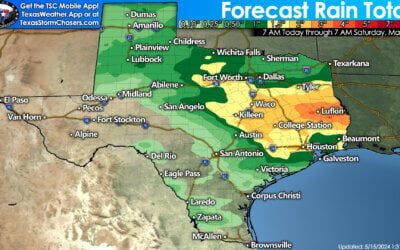
The Storm Prediction Center has placed a level 3 risk of severe weather – an enhanced risk – across the Big Country and North Texas. Aspermont, Snyder, Sweetwater, Abilene, Haskell, Brownwood, Wichita Falls, Graham, Stephenville, Gainesville, Sherman, Denton, McKinney, Fort Worth, Dallas, Cleburne, Waxahachie, Hillsboro, Corsicana, Canton, Greenville, and Emory are a few towns included in this enhanced risk. This means there is a 30% chance of severe weather occurring within 25 miles of your location.
A level 2 risk – the standard risk level for severe weather – includes the Concho Valley, Northwest Texas, Northeast Texas, East Texas, Central Texas, and the Hill Country. Crowell, Vernon, Guthrie, Big Lake, Sterling City, Ozona, Sonora, San Angelo, Brady, Junction, Fredericksburg, Burnet, Georgetown, Killeen, Temple, Waco, Fairfield, Bryan (College Station), Crockett, Centerville, Palestine, Paris, Texarkana, Marshall, Longview, Tyler, and Lufkin are included. Those within this level 2 risk have a 15% chance of experiencing severe weather within 25 miles of their location (like a home or office).
Finally, we have a marginal level 1 risk of severe weather. That risk includes the eastern Texas Panhandle, South-Central Texas, the southern Brazos Valley, into a sliver of Southeast Texas. The western delineation of this risk is where the dryline should be located (roughly). The southern delineations are where we should see a stronger cap and weaker lift prevent too many storms from developing. Those in this level 1 risk have a 5% chance of severe weather occurring within 25 miles of any given point, such as a house or office.
These regional severe weather outlook maps can each be clicked on for a full-screen version.
Now that I’ve shared who are in the severe weather risk zones let’s talk about some caveats of these outlooks. Storms don’t read maps and don’t care where lines are drawn. Please don’t become fixated on the exact line placements. These outlooks are updated five times a day, so the lines will probably change by this afternoon. If you’re in or near any risk level, consider this outlook an ‘early heads up’ that it would be wise to keep an eye on our weather radar app today.
I explained in my first paragraph that we have a few unknown factors that could change today’s setup – just like what we saw yesterday and have seen with most severe weather risks this year. Just because you’re in a risk zone does not mean you’ll actually be impacted by severe storms. If everyone in a risk zone were to be impacted, we’d have a super high risk of severe weather. We don’t have that.

One high-resolution weather model (that seemed to have a decent handle on this morning thus far) from 3 PM this afternoon until midnight. Keep in mind that it may not have the exact placement, timing, or number of storms correct. However, it provides a baseline.
Large hail and damaging straight-line winds are expected with the strongest storms today. Some hailstones may become quite large, especially as storms are first firing up in the western Big Country and western Concho Valley by 2-4 PM. Superceulluar storms with very large hail may also develop along a stationary front near the Red River eastward into North Texas. We’re in May – and storms with baseball size hail are certainly not uncommon.
However, and this is one of those ‘expectations’ that could change somewhat as we get a better grasp on how everything sets up, we should see storms grow upscale into a squall line or cluster. That is when the threat of damaging straight-line winds will increase along with the concern of wind-driven hail. A cluster of storms or a squall line will then accelerate and move eastward across the Big Country and North Texas by the late afternoon hours and into this evening. We’ll have to see how the time-frame evolves, but don’t be surprised if storms are coming in by the mid-afternoon, or if they end up coming in later in the day.
A few tornadoes will be possible. Low-level wind shear won’t be as strong today as what we saw yesterday across Missouri, Oklahoma, and in Texoma. However, very high instability values along with some low-level wind shear will allow for at least a low threat of tornadoes. We’ll have to watch for any storms that interact with outflow boundaries left over from yesterday as those can locally enhance tornado potential. Brief tornadoes are a threat with the squall line this afternoon and evening – in association with more widespread damaging straight-line winds. That line will probably continue moving east (perhaps a bit southeast) well into the evening.
Very high moisture values are in place across most of Texas (east of the dryline). Most storms today, whether they’re severe (with hail/wind/tornado) or not will be gully-washers. We are expecting some flash flooding issues, especially in areas that have already had heavy rains over the last week.
More storms on Thursday…

Click image for a full-resolution version.
We get to do all this over again on Thursday. Wind shear values will be lower, but we’ll still have plenty of instability and moisture for storms. So yes, more storms with a threat of hail and damaging wind gusts look probable by Thursday afternoon. Just like yesterday and like today, we’ll have to see how it comes together once we get past the prior day’s storms.
0 Comments