
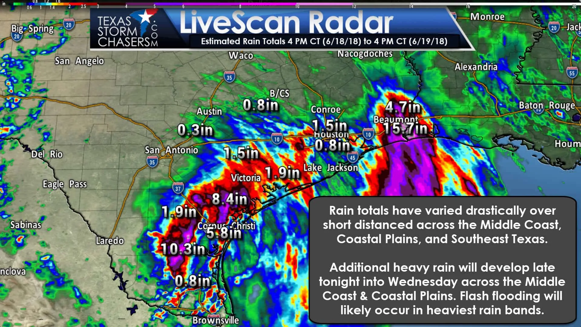
It hasn’t rained everywhere along the coast, but where it has, it has come down in buckets. Alice, Texas in South Texas reported over 9 inches of rain with 11″+ in Premont. An exact number is not available for Premont as the rain exceeded the gauge’s capacity. Beaumont and Port Arthur on the Upper Texas Coast have also had a bad time with numerous reports of flooding.
At least I can provide some good news in this update. The probability of widespread, heavy rainfall is lower tonight along the Upper Texas Coast. That means our friends in Beaumont and Port Arthur have a lower chance of experiencing a repeat of this morning. I can’t rule out a band of heavier rain setting up tonight into Wednesday morning, but the chance is lower compared to the Middle Coast up toward Galveston.
High-resolution weather models have done an abysmal job with the evolution of our storm system. The disorganized nature of the trough and lack of upper-level steering currents have both combined to make this a difficult forecast. Abundant moisture is in place as demonstrated by the flooding rains overnight and this morning.
The storm system responsible for flooding parts of the Upper Texas Coast and Middle Coast is slowly progressing south/west. That movement should alleviate some risk for additional heavy rains around Beaumont/Port Arthur tonight. Still, we could have pockets of heavier rain develop just because of the tropical-moisture levels in place.
An uptick in Heavy Rainfall Expected Tonight into Wednesday Morning
Since most models haven’t been handling this system well, we’re going to use something relatively new. The High-Resolution Ensemble Forecast is an experimental tool combining several different models and forecasting techniques. It has handled the past couple of days better than other models, so we’ll use it for display purposes in this blog.
This graphic does not display a simulated radar. In an uncertain or complex situation, an ensemble approach (many models run under slightly different circumstances) is preferable to a single model solution. If those different runs all show something similar confidence in a forecast increase. If different, that shows that a forecast may not necessarily verify or is more conditional.
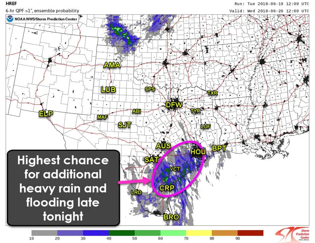
This graphic displays the probability of additional rainfall in excess of one inch in six hours – or the number of ensemble weather models (of which there are many) showing a similar solution. The HREF shows the highest probability of additional heavy rain tonight being across the Coastal Plains, or roughly a corridor from Corpus Christi to Victoria to Houston. Not everyone in this corridor will get heavy rain tonight, but we’ll be watching that general region for additional bands of training thunderstorms. We’ll probably have to wait until late tonight to early Wednesday for a resurgence in activity.
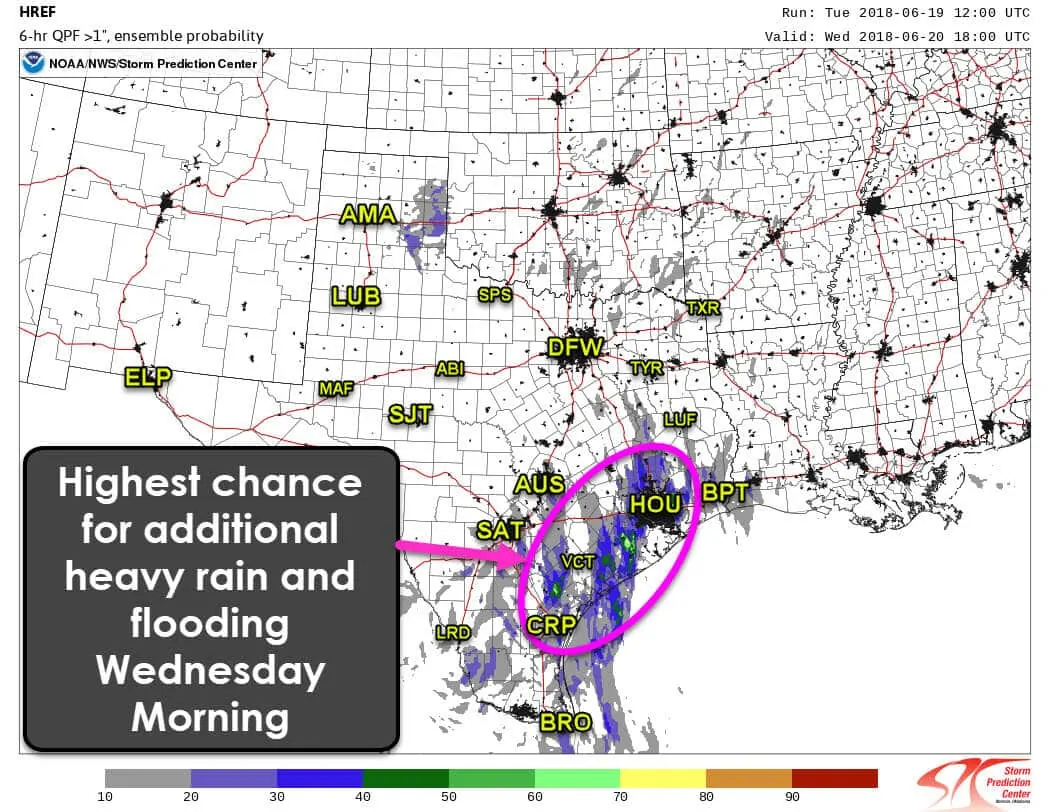
The signal for heavy rain from around sunrise to noon on Wednesday is in the same regions as late tonight. There is some increased signal that portions of Southeast Texas (around Houston) may have a better chance for heavier rainfall. Again, this is only a signal that the general region may have a higher chance for heavy rain, not a guarantee on specific locations. Not everyone will see heavier rains.
Additional Expected Rain Totals
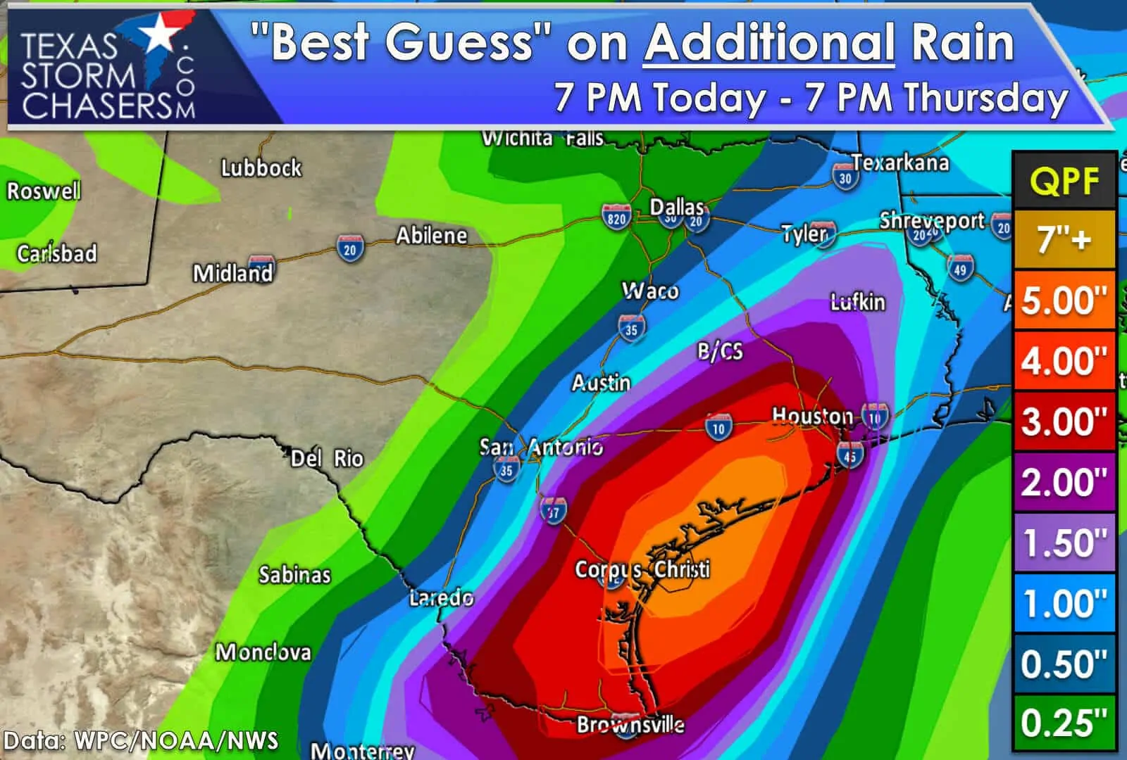
An additional three to five inches of rain may occur tonight through Thursday across the Coastal Plains, the Middle Coast, and South Texas. Some will see far less and some may see more. Amounts will vary locally and not be uniform as this regional rain forecast shows. If we can see 3 to 5 inches of rain over 2 days we should be alright in the flooding department. 3 to 5 inches of rain in a few hours will be problematic. It won’t take much rain to cause new flooding in areas that already have had a boatload of rain.
Higher rain chances will begin to be confined to the Rio Grande Valley, South Texas, and the Middle Coast after tomorrow. We could see rain chances continue into Thursday, especially across South Texas. The potential for additional heavy rains/flooding after tomorrow will depend on the evolution of our storm system.

0 Comments