
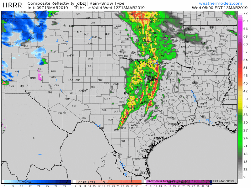
Simulated weather radar from the HRRR model through the late morning hours.
The leading edge of a line of strong to severe storms extends from Bonham to Greenville to Kaufman to Corsicana to Mart. South of that line, the storms are much more disorganized and not severe. They could still produce some gusty winds and brief heavy rain. The squall line farther north has caused plenty of wind damage across the D/FW Metroplex. We continue to see indications that the line of storms is capable of producing wind gusts of 60 to 65 MPH and it moves east through 7 AM. Forward motion is to the east at 45 to 50 MPH. We do expect the line will weaken as it continues moving east, but given very strong wind fields aloft, we could continue to see strong winds continue until the storms make east out of Texas later this morning. I don’t think we’re going to see the intensity or scope of the winds we saw across West Texas eastward into D/FW this morning, but it doesn’t take much to knock down tree limbs. A brief/weak tornado can’t be ruled out.
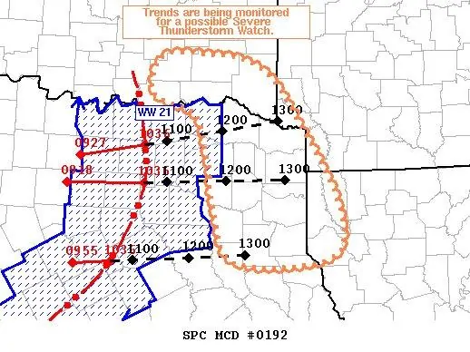
Here’s the latest from the Storm Prediction Center via a newly issued mesoscale discussion.
Mesoscale Discussion 0192
NWS Storm Prediction Center Norman OK
0559 AM CDT Wed Mar 13 2019
Areas affected…Northeast TX…Southeast OK…Far Southwest
AR…Far Northwest LA
Concerning…Severe potential…Watch possible
Valid 131059Z – 131230Z
Probability of Watch Issuance…40 percent
SUMMARY…Radar trends of an ongoing convective line will be
monitored closely and a Severe Thunderstorm Watch may be needed
across portions of northeast TX and adjacent southeast OK.
DISCUSSION…Convective line moving through north-central TX is
expected to continue eastward/east-northeastward over the next few
hours, moving into northeast TX and adjacent portions of far
southeast OK, far southwest AR, and far northwest AR. Thus far, this
line has produced numerous several wind gusts over 50 kt, with a few
reports of significant severe winds (i.e. gusts over 65 kt). The
low-level structure of the line currently still indicated a
well-organized system, with a sharp reflectivity gradient along its
leading edge and strong radar velocity values. VAD wind profile from
KFWS reveals a well-defined rear-inflow jet.
However, echo tops have been gradually decreasing during the past
hour or so, indicative of updraft weakening. The downstream airmass
is not thermodynamically favorable for line re-intensification and
the general expectation is for the diminishing intensity trend to
continue. Even so, the line is well-organized and may be able to
overcome the unfavorable thermodynamics. In any case, isolated
damaging wind gusts are possible, particularly if the line interacts
with any cells the develop within the warm-air advection ahead of
it.
Radar trends will be monitored closely and a watch may be needed if
trends suggest storm intensity will be maintained into northeast TX.

0 Comments