
Dense fog is once again a problem across parts of our state this morning. This morning’s round of fog has enveloped the Rio Grande Valley, South Texas, the Coastal Plains, all of Southeast Texas, and has snuck up into Central Texas at the time of this writing. Remember to use your low-beam headlights and give yourself a little extra room on the morning commute. Like the past couple of days we should have all that pesky fog burn off by lunchtime. Another foggy morning is expected tomorrow.
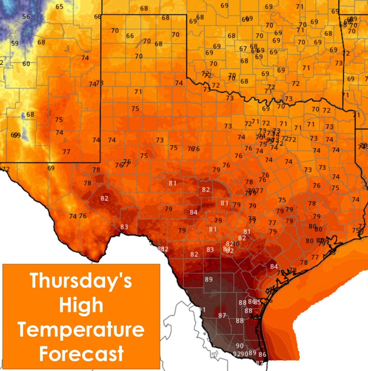
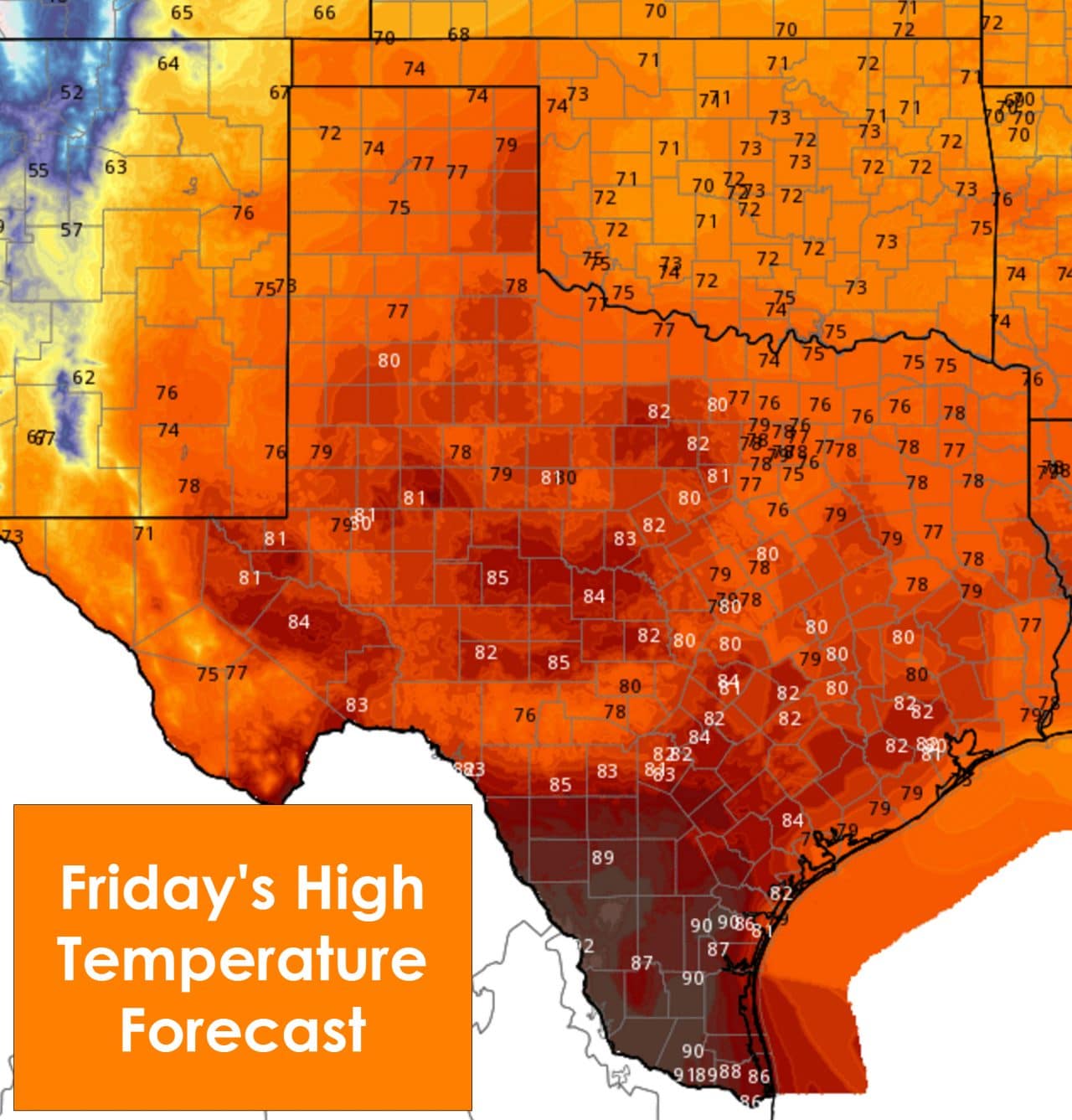
Even with dense fog this morning we anticipate another day with high temperatures well above average for December. The Rio Grande Valley and Deep South Texas will probably make it into the upper 80s and low 90s today. Yeah, I just said 90 degrees for a high temperature in December. We may be warmer in the winter months compared to our northern neighbors but 90 degrees is pushing it too far. The rest of Texas will top out in the mid 70s up into the low 80s this afternoon – all of which are 20-30 degrees above average for this time of year. Friday will be even warmer with most locations across Texas making it into the upper 70s to mid 80s. I do expect a couple new record high temperatures to be set Friday afternoon as temperatures will be 25 to 35 degrees above average for December. Tomorrow should be the warmest day before the weather becomes more active.
Warm air advection ahead of a strong storm system will really ramp up Friday night. A few showers will be possible across Central Texas, the Brazos Valley, North Texas, Northeast Texas, and East Texas. Overall coverage of rain will remain below 25 percent Friday night. Rain/storm chances ramp up into the scattered category on Saturday across South-Central Texas, Central Texas, North Texas, Northeast Texas, East Texas, and Southeast Texas. Everyone but Far West Texas has a chance for rain Saturday Night. THe heaviest rain chances including the possibility of severe thunderstorms will be along and east of Interstate 35 from southern Oklahoma south through the D/FW Metroplex, Waco, Austin, and San Antonio. The heaviest rains should be across Northeast Texas and East Texas overnight Saturday into the morning hours on Sunday. However everyone has a chance to get wet. Rain chances will end from west to east as Sunday progresses and the storms system moves out. In its wake temperatures will be much more seasonal and much cooler compared to the next two days.
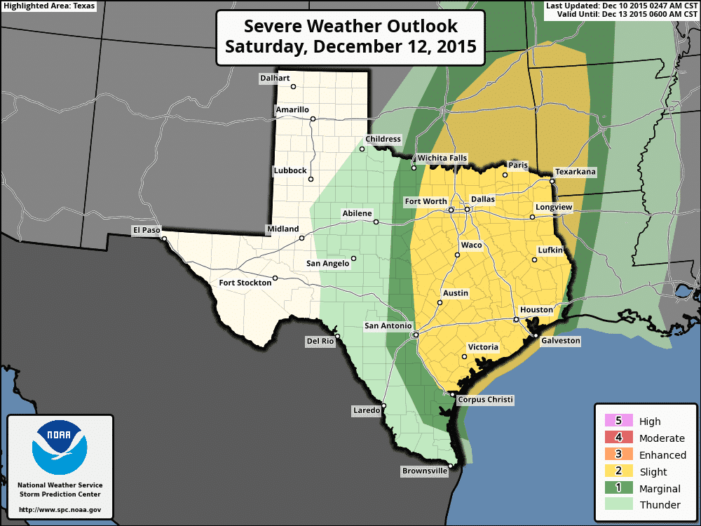
There will be a severe weather risk beginning Saturday Afternoon across North Texas and Central Texas. There remains some uncertainty on how the inital severe weather threat will evolve so expect timing/spatial refinements. By Saturday evening its likely a line of thunderstorms will fire up on the leading edge of a east/southeastward moving cold front. Some of the storms in the line could be severe with damaging wind gusts. A couple tornadoes are also possible as there will be plenty of wind shear. The threat for a couple severe storms could continue into Sunday morning across Northeast Texas, East Texas, and Southeast Texas. If we have more sun on Saturday and the atmosphere becomes more unstable the severe weather threat will increase. Likewise more clouds/rain on Saturday will help keep the severe weather threat more limited and localized. Check back for updates as changes can be expected as we get closer to Saturday.
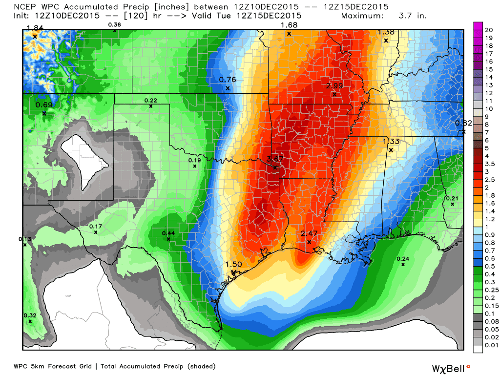
Projected rain totals with the weekend storm system
There will be a threat of localized flash flooding in Northeast Texas and East Texas on Saturday Night and Sunday. Widespread rain accumulations of 2 to 3 inches will be possible. Some isolated amounts may exceed 4 inches. Considering soils remain saturated we could see some localized flash flooding issues. The additional rain certainly won’t help with the already elevated river and lake levels. Rain totals across the remainder of the state will be lower – but still decent for a December event. The severe weather and flash flooding threat should end for Texas by Sunday afternoon as everything moves east.
The winter weather potential for the Texas Panhandle seems to be lowering. Weather models are coming in with less potential precipitation falling. At this time we’ll go with up to an inch of snow in the Oklahoma Panhandle and bordering Texas Panhandle counties. The remainder of the Panhandle will likely receive only a few flurries up to perhaps half an inch of snow. We’ll still have to watch out for a few slick spots but the overall event potential seems minor at this time.
After the storm system moves out we’ll have fairly nice weather for the start of the upcoming work week. High temperatures will be in the 50s and 60s with low temperatures in the 30s and 40s. Still no sign of a major arctic intrusion in the next 7 days.

0 Comments