
Our much-discussed arctic cold front has begun its push south into the Texas Panhandle. The front will make steady progress south through most of Texas by this evening. It’ll push through the southern third of Texas early Sunday. Those in the Rio Grande Valley may postpone its eventual arrival by a day or two, if it stalls out. Likewise, those in Far West Texas and the Borderland will remain warm for a few days thanks to the Davis and Guadalupe Mountains shunting the arctic airmass eastward.
Once temperatures fall below freezing across the northern half of Texas this afternoon or this evening, they won’t rise above freezing until Tuesday or Wednesday. Low temperatures across the northern two-thirds of Texas will range from below zero into the teens, especially on Monday, Tuesday, and Wednesday mornings. The southern third of Texas will drop below freezing at least a couple of those nights. It’s going to be pretty darn ‘tootin cold by Texas standards. We’ll all rise above freezing by Wednesday afternoon as a warmup begins, though another strong cold front will arrive on Thursday. Be mindful of pipes freezing up, and take appropriate precautions for your furry family members. Yes, that includes your uncle, who refuses to wax his back.
Freezing Drizzle, Freezing Rain, Sleet, and Snow
Winter precipitation chances have increased for the Hill Country, Central Texas, North Texas, Northeast Texas, the Ark-La-Tex region, East Texas, the Brazos Valley, and even portions of Southeast and South Texas. A whole ‘lot of dry air in the low levels of the atmosphere makes the start time of this event difficult to pin down. As it stands, we may have pockets of freezing drizzle, light freezing rain, or even light sleet showers develop by mid-afternoon Sunday in the regions mentioned above. That activity may be isolated initially before becoming more widespread Sunday evening through Monday afternoon. A warm layer of air in the mid-levels of the atmosphere is why it won’t simply be snow. It will be cold enough in all levels of the atmosphere for snow in Northeast Texas on Monday.
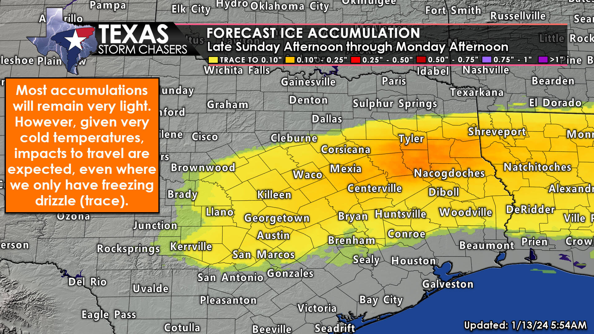
Winter precipitation chances have increased for the Hill Country, Central Texas, North Texas, Northeast Texas, the Ark-La-Tex region, East Texas, the Brazos Valley, and even portions of Southeast and South Texas. Freezing drizzle and light freezing rain will be the main precipitation type, except in Far Northeast Texas. Ice accumulations will generally be a trace to one-tenth of an inch; though some may see slightly more. Regardless, even a trace of ice will cause slick spots on bridges, overpasses, and even roads.
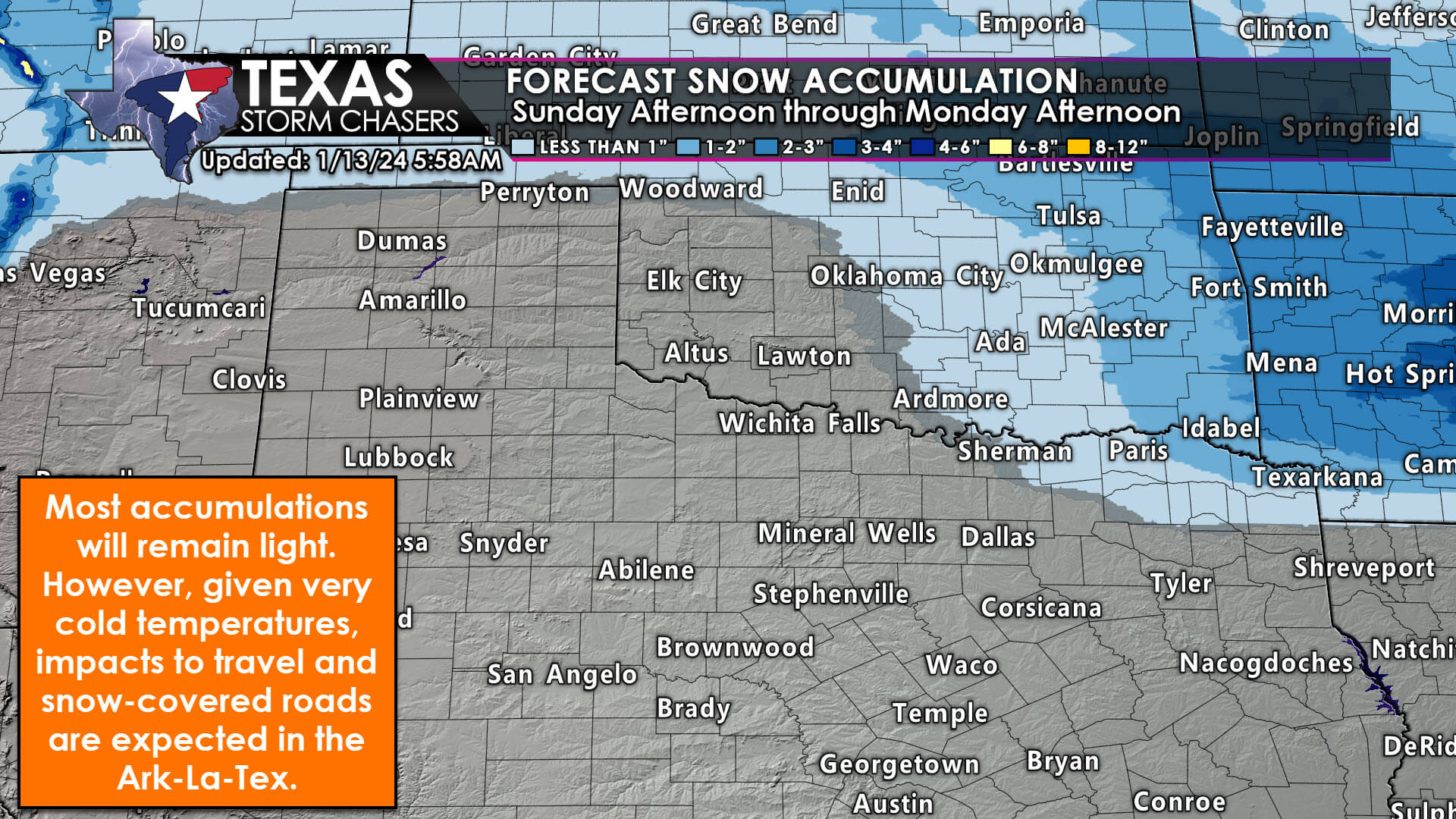
One-half to three inches of snow are possible in Far Northeast Texas, generally from Paris to De Kalb to Texarkana. South of there, we’ll tend to see freezing rain or sleet versus all snow.
Forecast ice accumulations are on the light side. However, impacts to travel are likely even in areas that only experience spotty freezing drizzle. That’ll be due to very cold temperatures. As February 2021 demonstrated, very light freezing drizzle or freezing rain in a very cold environment can cause roads to turn into slicky-slicky doom without much lead time. Be mindful of that possibility as soon as Sunday afternoon, but more likely Sunday evening through Monday afternoon. Where colder mid-level temperatures are in place in Northeast Texas, one-half to three inches of snow will be possible. That may also mix with freezing rain and sleet, resulting in some ice accumulations.
For most locations mentioned above, there will not be enough ice accumulation to cause a damaging ice storm to trees or infrastructure. Impacts will mainly be travel-related. Of-course, it will be very cold across all of Texas, which will be the most widespread weather threat.
When does it end?
While temperatures will remain below freezing through Tuesday or Wednesday, sublimation (wind) and some sunshine should help improve most deteriorated road conditions as we get into the second half of Monday or Tuesday.
This remains a situation where adjustments to the forecast may be needed later today or tonight. We’ll do our best to keep you updated. You can check on real-time Texas road conditions on TxDOT’s website at DriveTexas.org
Get the FREE Texas Storm Chasers Mobile App for your local weather forecast, interactive weather radars, live Texas weather coverage, and more! Available in your device’s app store.
You can get your current local weather, upcoming local weather forecast, and interactive winter radar in our free Texas Storm Chasers app in your device’s app store, or at https://texasweather.app./
Morning! James Cummings Texas (Raymondville) 👍🏽👋🏽🌬️🙂
Thank you David!! Yes you look very nice, unlike Crashey the Cold Front!! Ice, Ice Baby not a good thing.
Blessings ❤
Good Morning Texas! 🇺🇸♥️