
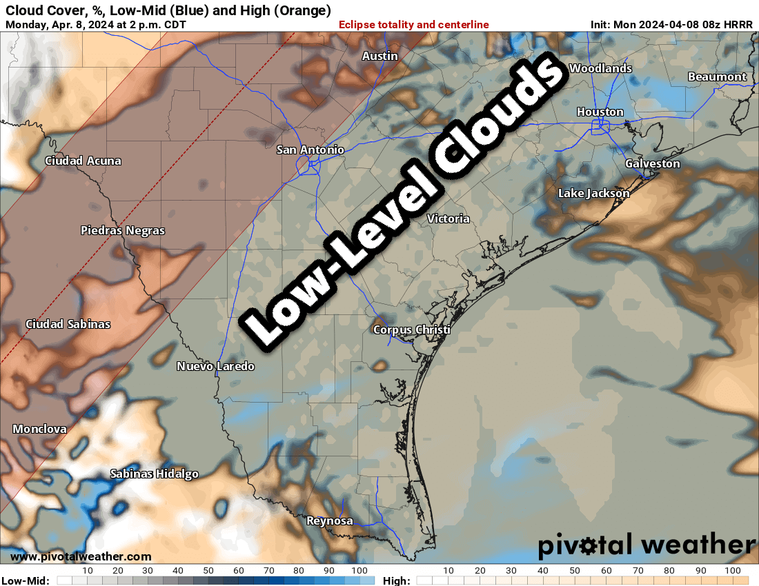
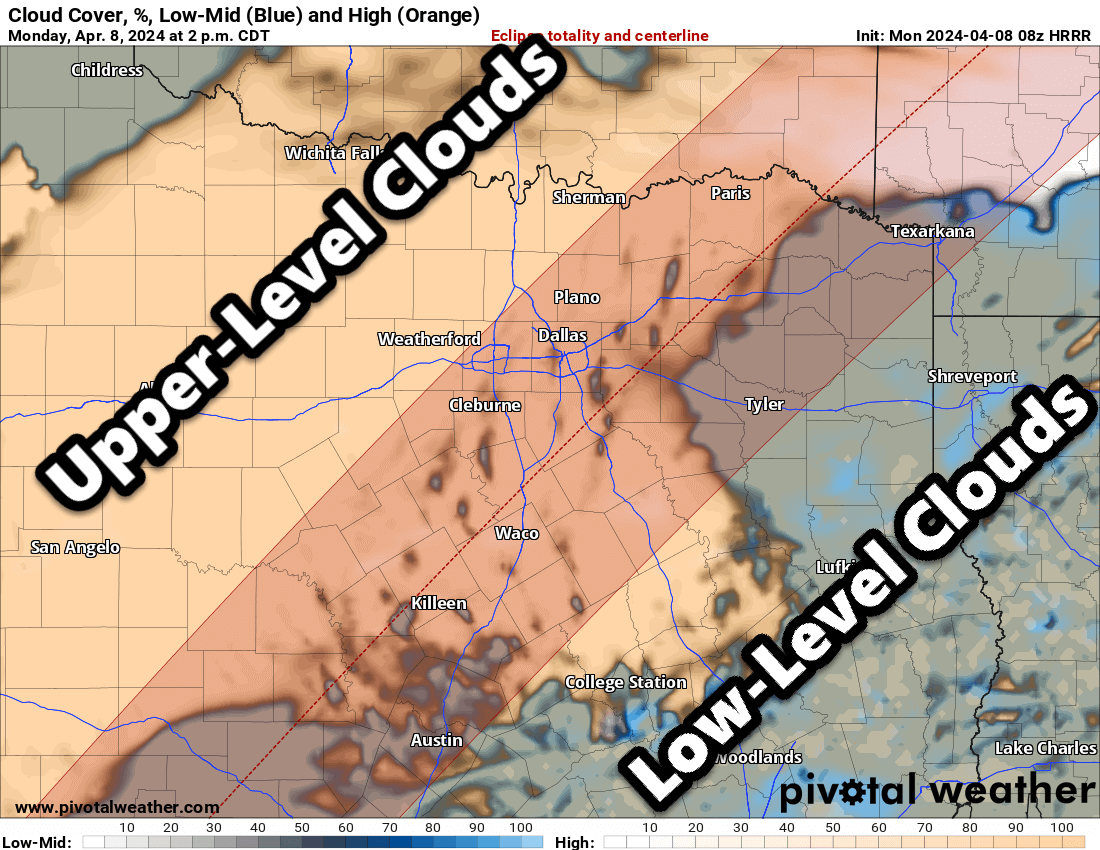
The eclipse is hours away and clouds are moving north from the Gulf of Mexico. An increase in upper-level clouds is expected nearly statewide by early this afternoon. Low-level clouds will advect northward with higher moisture levels from the Gulf of Mexico this morning. By eclipse time between 1 and 2 PM, we expect low-level clouds across the Edwards Plateau northeast toward Central Texas. Those low clouds may remain south of Interstate 20 through Eclipse time. While thinner upper-level clouds are expected across North-Central Texas, Texoma, and Northeast Texas – that may still allow the opportunity for a view. Regardless of direct viewing, we expect dimmer light to dusk-like conditions from the path of totality – spreading outward across most of Texas early this afternoon.
Severe Storms Develop After 2-3 PM
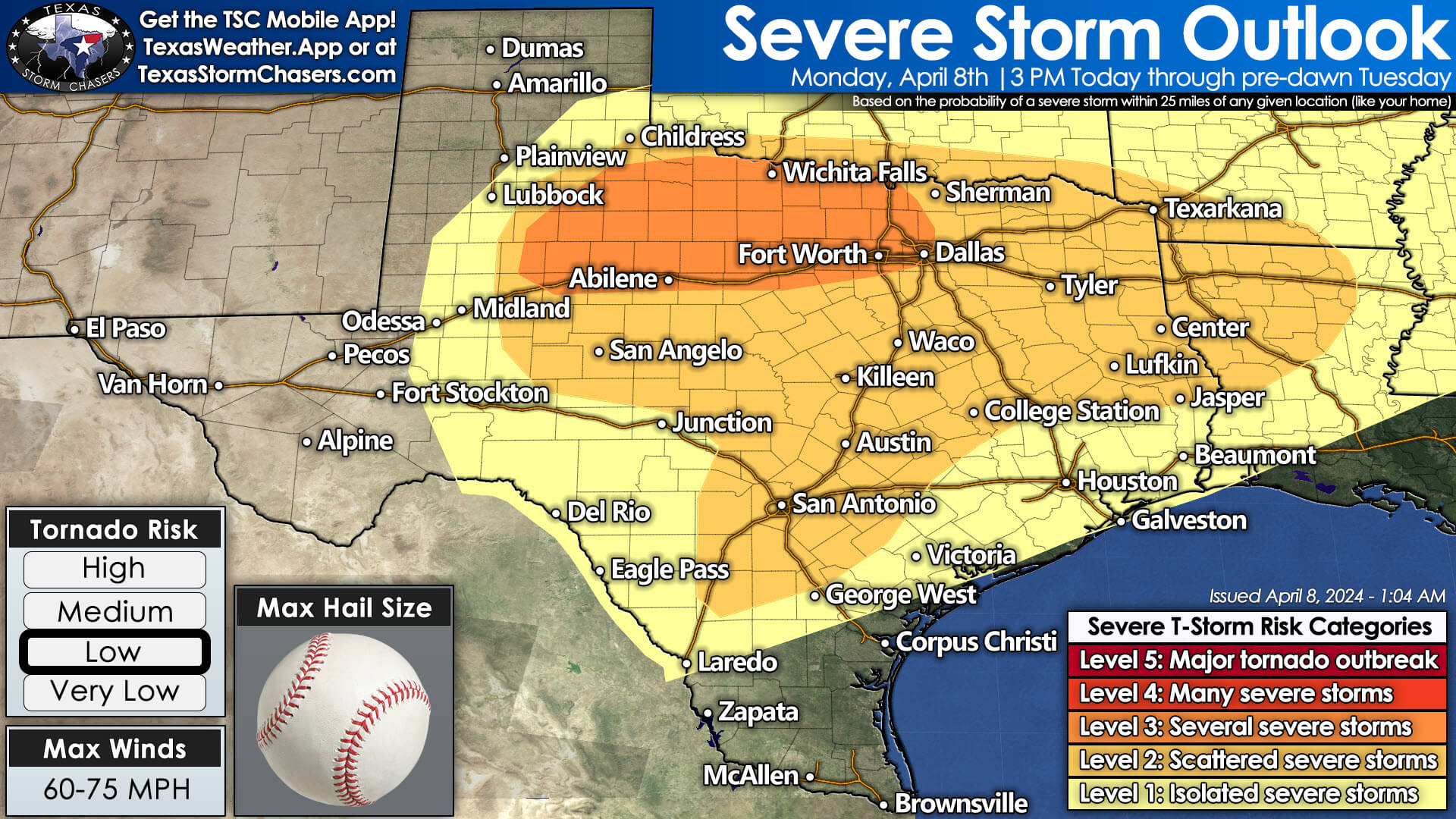
Scattered severe thunderstorms will develop between 2 and 4 PM across portions of Central Texas, the Brazos Valley, and East Texas. Most activity will move north/northeast, though some storms may move more northeasterly through the late afternoon. The most intense storms will likely be severe, with the threat of hail up to the size of baseballs, localized damaging wind gusts over 65 MPH, and some tornado threats. Just how high the tornado threat becomes will depend on the number of storms and just how much low-level instability is available. The more storms in a small area, the less likely a single storm will become dominant and sustain tornadic behavior. We’ll monitor trends, as other ingredients will be in place to support a tornado threat. These storms will move north/northeast toward North-Central and Northeast Texas by dinner-time and likely into those regions afterward.
Late this afternoon into this evening, scattered severe thunderstorms will also develop east of a dryline in West-Central and Northwest Texas. These storms will be in an environment supportive of very large hail up to the size of baseballs, localized damaging wind gusts, and perhaps a tornado. The overall tornado threat looks lower than that of areas farther east, but it may increase slightly after 8 PM. These storms will move more easterly and toward Texoma and North Texas tonight. Numerous thunderstorms are expected in Northwest Texas, Texoma, North Texas, and Northeast Texas tonight into Tuesday morning. Some storms will be severe.
Severe storms likely on Tuesday, too
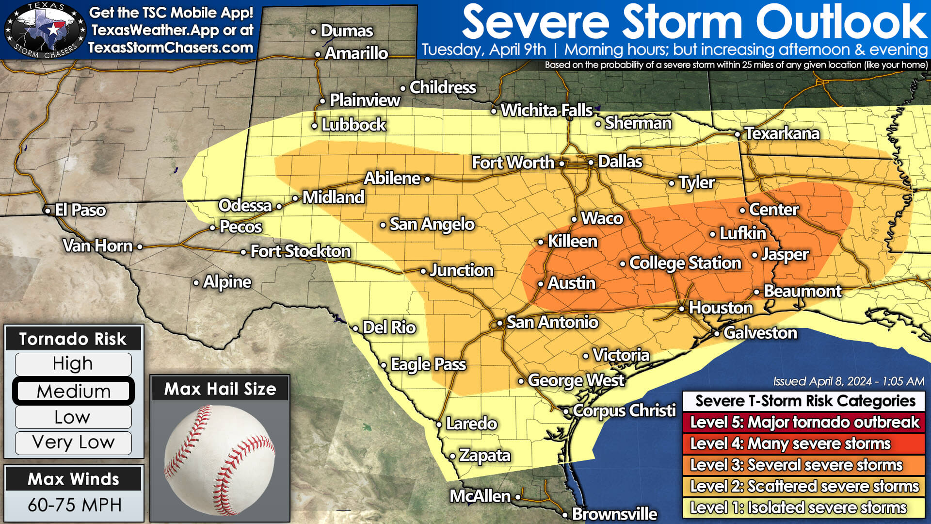
Severe thunderstorms are possible, if not probable, again on Tuesday across the same regions and South-Central Texas, the Coastal Plains, and Southeast Texas. What unfolds will depend a bit on how today plays out, but tomorrow could also be a busy severe weather day with very large hail, damaging winds, and a few tornadoes. We may have storms still underway at sunrise on Tuesday, and those may intensify and move east as a cluster. New storms are likely Tuesday afternoon through Wednesday morning. We’ll get more descriptive about tomorrow’s severe weather threat once we better grasp today and tonight.
Heavy rain and flooding threat in Texas through Thursday
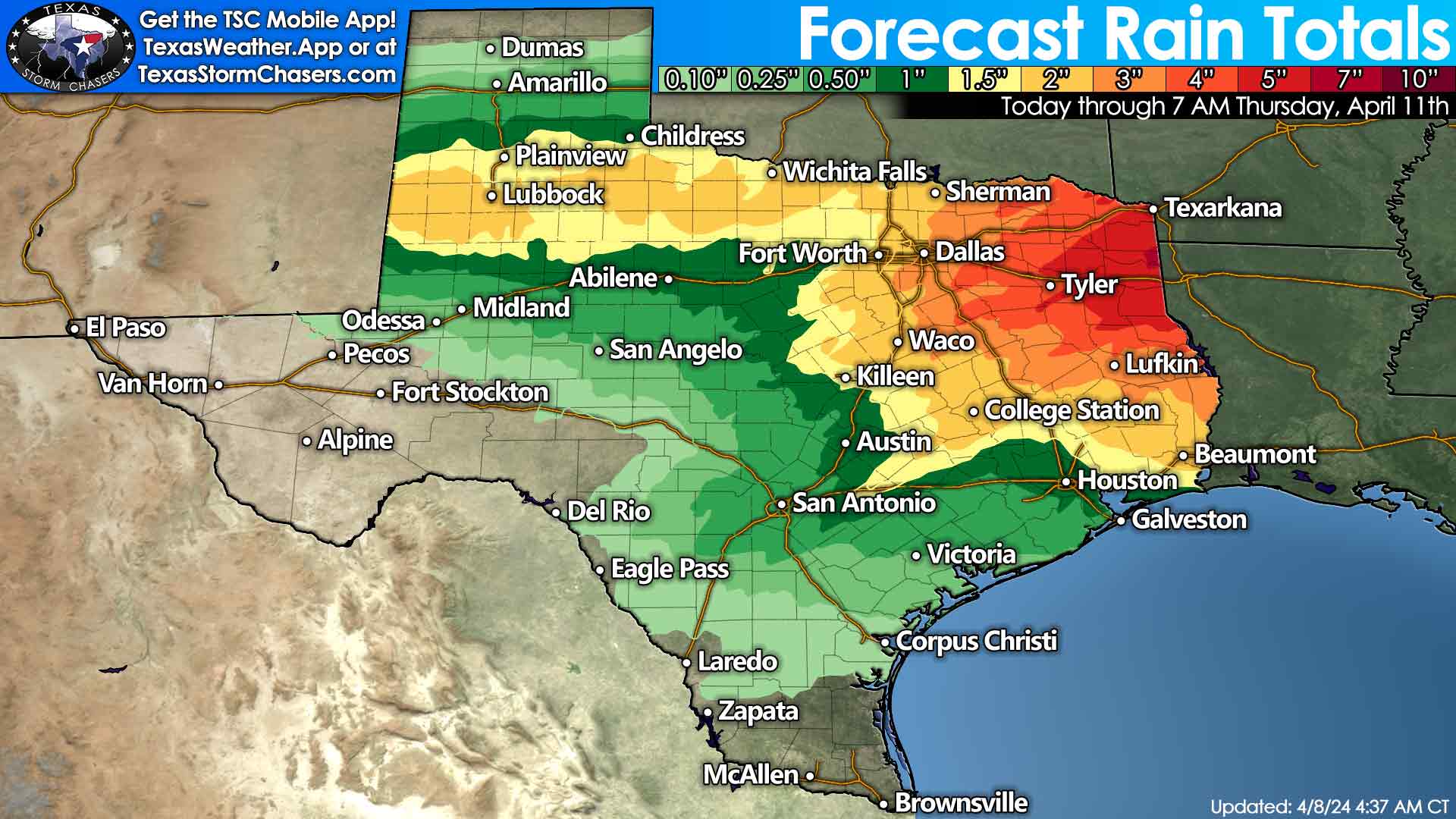
On Tuesday and Wednesday, heavy rain will result in flash flooding in parts of North Texas, Northeast Texas, and East Texas. Three to eight inches of rain are possible by the time rain stops falling on Thursday in eastern North Texas, Northeast Texas, the Ark-La-Tex, and East Texas. One to three inches of rain will be possible across West Texas, Northwest Texas, Texoma, North Texas, into the Brazos Valley, and Southeast Texas. Amounts will be lower in regions to the southwest.
My FREE & AWESOME weather app for radar/alerts/more: https://texasweather.app/
My website, also with radar: https://texasstormchasers.com/radar
The 24/7 Texas weather tracker & music: https://www.youtube.com/watch?v=lNZuPEWS5AI&t=0s
Storm chaser videos: https://www.youtube.com/texasstormchasers
Facebook: https://www.facebook.com/TxStormChasers
TikTok: https://www.tiktok.com/@texasstormchasers
X (Twitter): https://twitter.com/TxStormChasers

0 Comments