
A total solar eclipse followed by a two-day severe weather outbreak has made for a busy week across Texas. We have one more round of thunderstorms this morning and afternoon across Texoma, North Texas, Central Texas, the Brazos Valley, Ark-La-Tex, and East Texas. A complex of rowdy thunderstorms will continue moving across the Golden Triangle and Upper Texas Coast through mid-morning. Once those storms exit Texas to the east, the threat of severe thunderstorms will quickly diminish.
The final round of rain and storms later this morning into the afternoon across the regions mentioned above will produce heavy rain, small hail, gusty winds, and frequent cloud-to-ground lightning. That activity will exit Texas to the east this evening, ending our multi-day thunderstorm event. Heavy rainfall may result in additional flooding, so staying informed and mindful of high water on roads is crucial.
There have been severe flooding impacts in portions of the Golden Triangle, specifically from Woodville to Jasper to Kirbyville. Water will take much longer to drain in areas where over ten inches of rain fell, underscoring the importance of staying updated about the weather conditions.
Strong northwesterly winds will occur across Texas today as the upper-level storm system responsible for our storms departs. Some locations may experience wind gusts over 45 MPH out of the north/northwest. Winds should calm down later tonight. A cooler, dry airmass will arrive, but we’re not dealing with any crashy cold front situations.

Thursday through the Weekend will be dry across Texas. High temperatures across Texas will be in the 70s and 80s on Thursday, climbing back into the 70s, 80s, and 90s over the weekend. The wildfire threat will increase over the weekend across the western half of Texas.
Severe Storms Return Monday
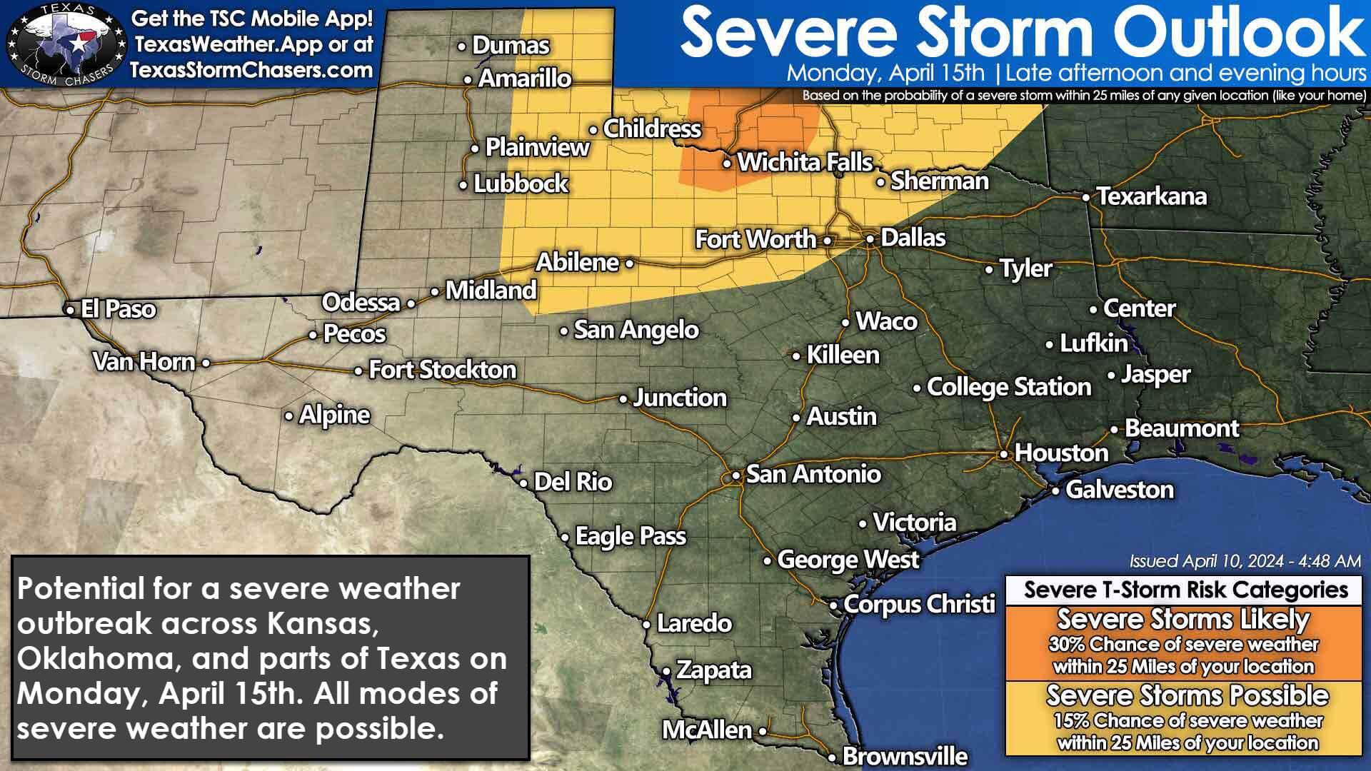
Our next upper-level storm system will arrive on Monday. Scattered severe thunderstorms are probable by Monday evening across the eastern Texas Panhandle, Northwest Texas, Texoma, the Big Country, and North Texas. Monday’s setup has the makings of a classic southern plains severe weather outbreak across Kansas, Oklahoma, and at least some of Texas. The threat of thunderstorms, some on the rowdy side, will likely expand further into Texas on Tuesday and Wednesday. Some heavier rains are also on the bingo card. Enjoy the calmer weekend because we’ll return to an active severe weather pattern next week.
Helpful Links
My FREE & AWESOME weather app for radar/alerts/more: https://texasweather.app/
My website, also with radar: https://texasstormchasers.com/radar
The 24/7 Texas weather tracker & music: https://www.youtube.com/watch?v=lNZuPEWS5AI&t=0s
Storm chaser videos: https://www.youtube.com/texasstormchasers
Facebook: https://www.facebook.com/TxStormChasers
TikTok: https://www.tiktok.com/@texasstormchasers
X (Twitter): https://twitter.com/TxStormChasers

Brandon McHenry
Kindell McHenry fml. Hopefully no hail.
Um, er… I need to hang just one load of laundry out…. I’m taking a chance on it LOL
Mother Nature has a sense of humor, I had almost the entire load hung and it started sprinkling, I removed said clothes and went inside, sprinkling stopped, I went out and put about half the load back up and yepper, it started spitting AGAIN, removed said clothes and plopped them in the dryer (which I hate running) and 3 mins later the sun came out……… the clothes are out now 🤣