
A wet weekend is in store for nearly all of #Texas. We’ll see numerous #thunderstorms get going this afternoon, which will only be the first of several rounds of #rain that’ll continue through Sunday. Some #storms may be severe this afternoon through Saturday afternoon – with large #hail and damaging #wind gusts. The overall #tornado threat is very low. Our main issue will likely be the increasing frequency, and perhaps the severity, of #flooding in some areas. Overall #rain totals will range from a tenth of an inch across Far West Texas to over half a foot in Central Texas, Hill Country, Edwards Plateau, South Texas, and the Rio Grande Plains. Beneficial rains are forecast across many regions of Texas. Some folks may get more rain over the next three days than they’ve seen over the last six to ten months! That’ll put a dent in the drought across western portions of Texas.
00:00 – Intro
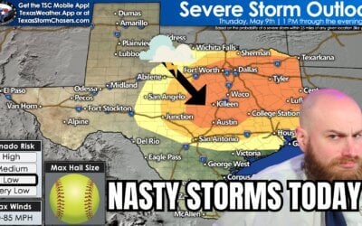
01:53 – Today’s Severe Storm Risk
03:34 – Saturday’s Severe Storm Risk
04:39 – Tonight’s Flood Threat
05:57 – Saturday’s Flood Threat
07:30 – Sunday’s Flood Threat
08:07 – Weekend Rain Totals
09:23 – Rain & Storm Timing
13:25 – Closing remarks & Baldyinchiefisms
Get the FREE Texas Storm Chasers Mobile App! Available in your device’s app store, or at https://texasweather.app/
DISCORD: https://discord.gg/a6gRBZX9CU
**
#TXwx #texasstormchasers #texasflood #txflood #turnarounddowndrown
0 Comments