
I’m going to start this discussion off with some love. The hype machine is in full force for tomorrow’s threat, prior postings from myself included.
Let’s sit on down and take a breather. I’m not making this discussion to scare the pants off anyone. In fact, I create these discussions as a way to help better inform. Knowledge is power, and even if a tornado comes rolling down your street tomorrow, if you implement your safety plan, you’ll be just fine.
We know some suffer from storm stress and anxiety. It’s a real thing. The National Weather Service has a great group resource set up to help those with storm anxiety here. Take a gander at it sometime today.
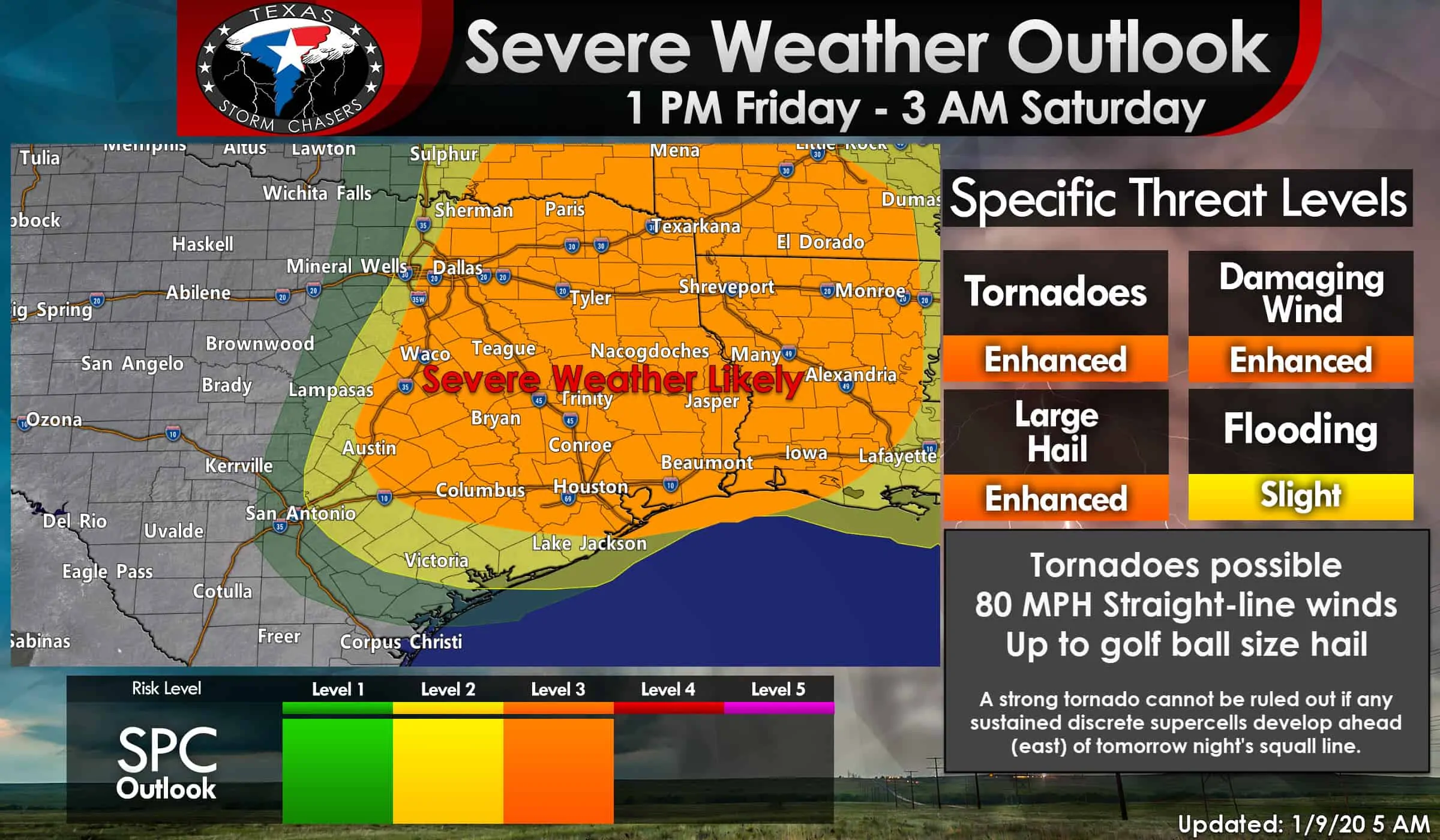
Severe weather threat expands farther west and south tomorrow; in addition to the eastern third of Texas
Those who watched my video briefing last evening may recall I mentioned data was trending farther west and slower. That trend did continue with the overnight weather model data. As such, the new severe weather outlook from the Storm Prediction Center has expanded severe weather probabilities farther to the west and south.
All images within this post may be clicked for a full-screen version.
To simplify matters and reduce confusion, we’re going to partially dispense with the whole ‘level 1, level 2, blah blah’ locations. The western edge of the risk zone is defined as where a squall line will fire up tomorrow night. There is about a 30 to a 40-mile gap between ‘little risk’ and the level 3 risk with the western delineations. If you’re in any of the risk zones, you’re in a severe weather risk late tomorrow afternoon and tomorrow night. It merely comes down to that.
Severe weather is likely in North Texas, Central Texas, the Brazos Valley, Southeast Texas, the Golden Triangle, East Texas, and Northeast Texas. Yes, I just listed a big chunk of real estate. Not everyone in the regions mentioned above will directly deal with severe weather. A severe thunderstorm is defined as quarter size hail or larger, winds of 58 MPH or higher, and of course, tornadoes. Those in the orange-shaded regions have a 30% chance of severe weather within 25 miles of a given point (like your home). Put another way, that’s a nearly 1 in 3 chance of severe weather nearby tomorrow evening and tomorrow night.
A capping inversion will be in place tomorrow morning, leading into the early afternoon hours across the risk zone. That cap will act as a lid, preventing potent thunderstorm development. One question is whether semi-discrete thunderstorms can punch through that cap in North Texas after lunch-time, but before stronger lift arrives later in the day to eliminate the cap. If that development occurs, we could see a few supercelluar thunderstorms capable of producing all modes of severe weather (very large hail, damaging winds, tornadoes). As they race off toward Northeast Texas. This scenario may happen, or the cap may hold until the late afternoon hours when stronger upper-level lift arrives. It’ll be something we watch closely and will update in future forecasts.
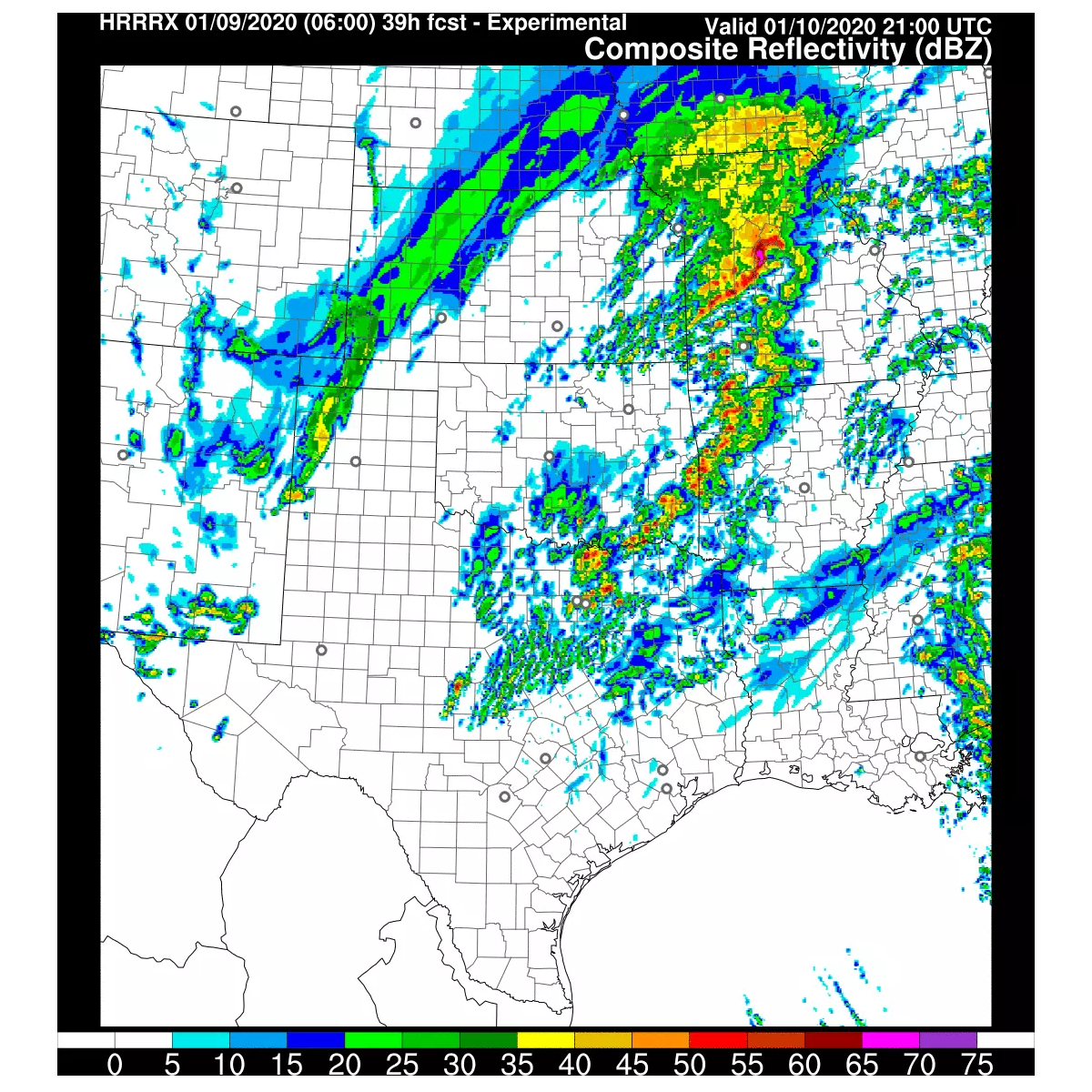
A robust upper-level storm system will result in increasing lift and a weakening of the capping inversion late Friday afternoon. A line of strong to severe thunderstorms should erupt not too far west of Interstate 35 ( west of Gainesville to Fort Worth to Lampasas to Johnson City to near San Antonio). Exactly where the initial development of the squall line takes place will probably change a bit by the time we get to tomorrow afternoon. Rapid upscale growth into a squall line versus discrete storms should take place as a cold front moves east.
Damaging straight-line winds of 60 to 80 MPH are expected with stronger sections of the squall line late tomorrow afternoon into tomorrow evening. Once the squall line develops near or just west of Interstate 35, it’ll race east all the way to Arkansas and Lousiana. That’s a lot of Texas real estate to cover. Brief tornadoes could occur within more broad areas of hurricane-force straight-line winds in bowing line segments. While not typically an issue during the cool season, we may even see some wind-driven quarter to golf ball size hail in the most intense storms within the squall line. I want to emphasize that the strongest storms in the squall line could produce significant severe weather (hurricane-force winds, tornadoes). That significant severe weather threat would include the Brazos Valley, Southeast Texas, the Upper Texas Coast, East Texas, and Northeast Texas.
There is a chance for discrete thunderstorm development ahead of the squall line late tomorrow afternoon into tomorrow night in the Arklatex, East Texas, southward toward the Upper Texas Coast. Any discrete thunderstorms that can establish themselves will likely become supercelluar. Extreme low-level wind shear, in combination with other favorable ingredients, would support the potential for a strong tornado risk with any established supercelluar thunderstorms.
Take note that this risk would likely be after dark in East Texas and Southeast Texas. We’ll have to watch tomorrow evening just in case any discrete storms can develop ahead of the eastward-moving squall line. If the cap is too strong ahead of the squall line, we would only see ‘streamer showers’ and weaker thunderstorms. The squall line itself will have a widespread damaging wind threat along with a risk for tornadoes.
Individual thunderstorms will move quickly to the north/northeast. The squall line itself will tend to move east, perhaps a bit north of east. Much of the severe weather threat tomorrow will occur after sunset. Night-time severe weather events are even more dangerous. Fast storm speeds add another layer of danger.
Once the squall line moves east of Texas early Saturday morning, the threat for severe weather will end in our state. Significant severe weather will unfold Saturday morning in Louisiana, Mississippi, eventually pushing into Alabama and the Florida Panhandle.
Flooding potential has also increased
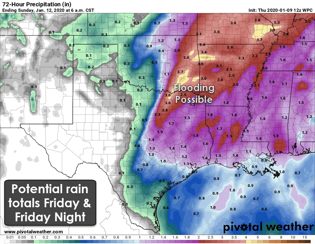
If the severe weather threat wasn’t enough, we’re also keeping an eye on an uptick in the heavy rain potential. Portions of North Texas, including the D/FW Metroplex up toward Sherman and Paris, could see localized rain totals near four inches. Recent dry weather helps, but four inches of rain in a few hours during the winter (dormant vegetation) means some flooding is possible. Rain totals of one to two inches across East Texas, the Brazos Valley, and Southeast Texas are expected Friday night.
Snow potential in Texoma and North Texas on Saturday
There is a chance of light snow flurries in Texoma and North Texas, generally along and north of Highway 380, Saturday morning, or early Saturday afternoon. Accumulations are not expected at this time, but it is not out of the question that could slightly change if optimal conditions materialize. We’ll deal with the snow dreams a bit later when we get this severe/flooding issue better contained.


0 Comments