
It has been a warm and relatively pleasant weekend across Texas. The weather certainly does not compare to the unpleasantness of six years ago when we were still dealing with the leftovers of the Cobblestone ice storm. We are keeping an eye on some potential for winter mischief come Tuesday morning, but that has far less potential for impacts compared to our more memorable winter weather events. Nevertheless, snow in Texas is in itself a significant event and all the more enjoyable when it doesn’t turn roads into icy gridlocked nightmares. Our roads are usually gridlocked nightmares without Mother Nature’s interference.
Cold front’s progress south on Monday and Tuesday
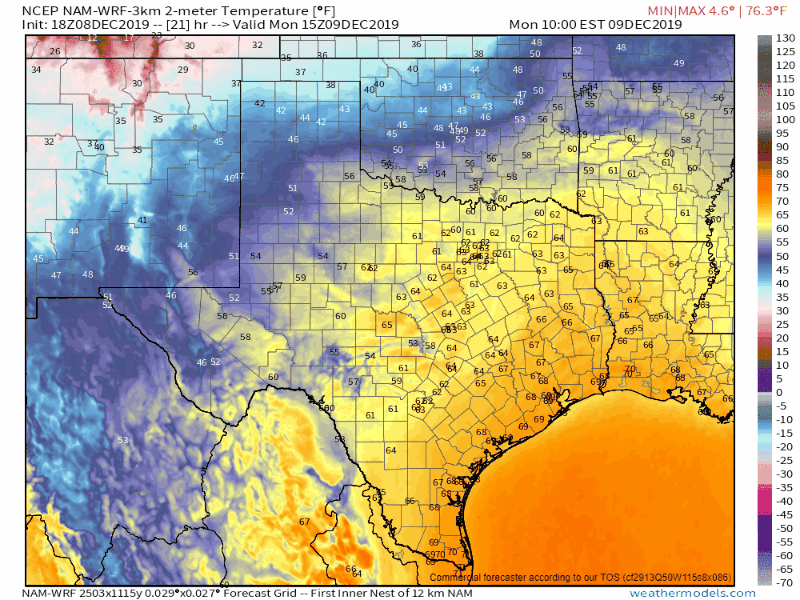
While we’ve enjoyed warm weather, that will conclude a cold front moves south into Texas on Monday and Tuesday. The front itself won’t bring an abnormally cold airmass for December, but it will knock temperatures back down toward normal for the pre-Christmas season. Much colder weather will be in place across the entire state by sunrise Tuesday. Temperatures will remain cooler and more seasonal throughout the workweek. We’ll start a slow warming trend as we approach the weekend with above-average temperatures returning on Saturday.
Areas of rain showers will accompany the southward-advancing cold front. This is not a scenario where severe thunderstorms or flash flooding are anticipated. Monday Night and Tuesday will be the period with the highest precipitation coverage. Rain will be exiting Texas to the east and moving off the coast on Tuesday evening.
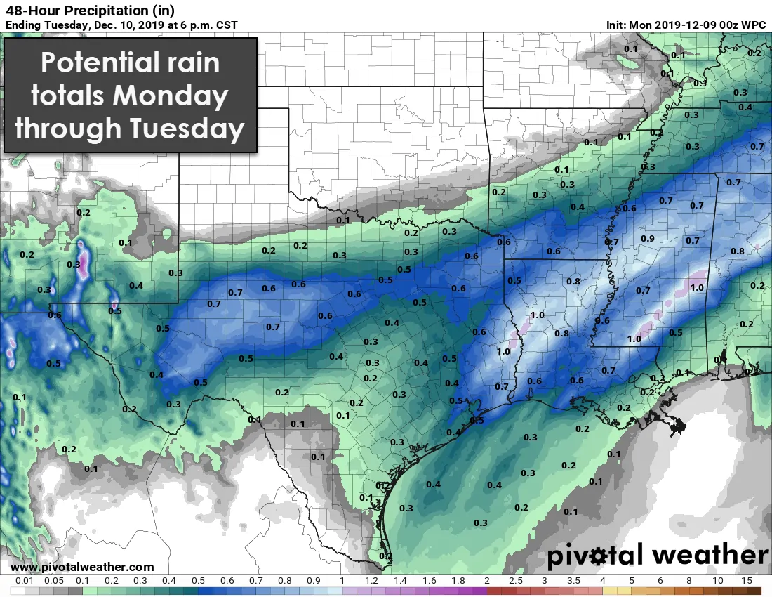
Most locations will receive a trace to three-tenths of an inch of rainfall accumulation. Locally higher rainfall amounts between one-half inch and one inch are possible in the Permian Basin, Big Country, Concho Valley, eastward into Northeast Texas, and Far Southeast Texas.
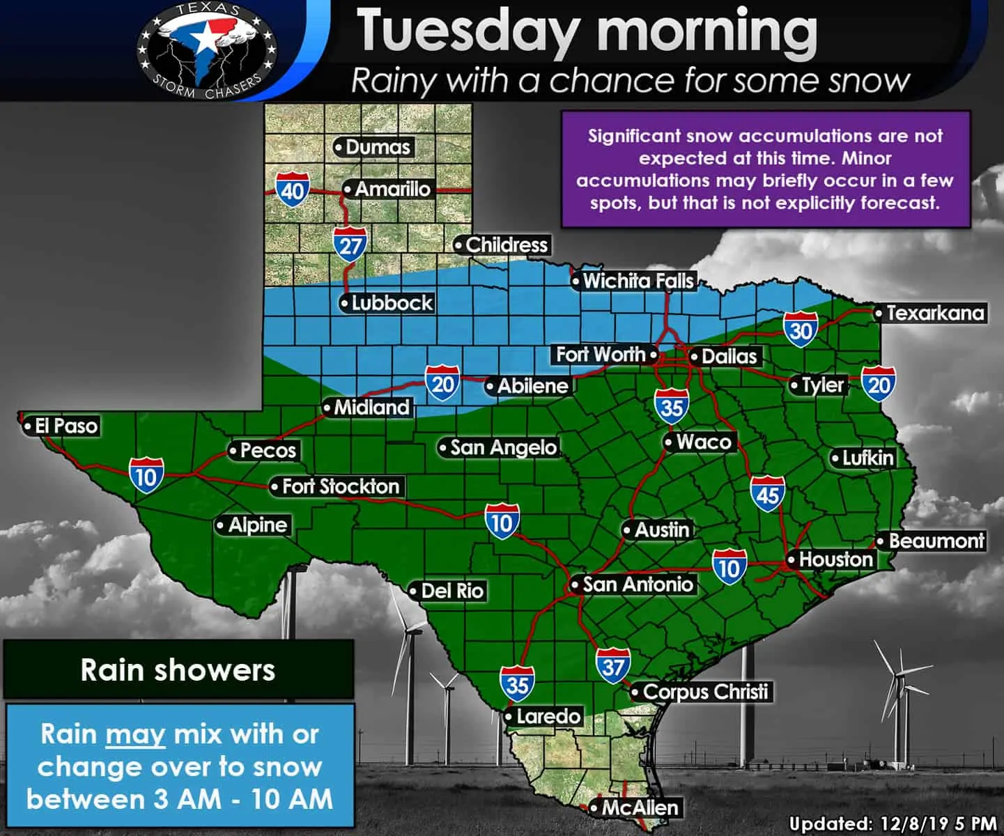
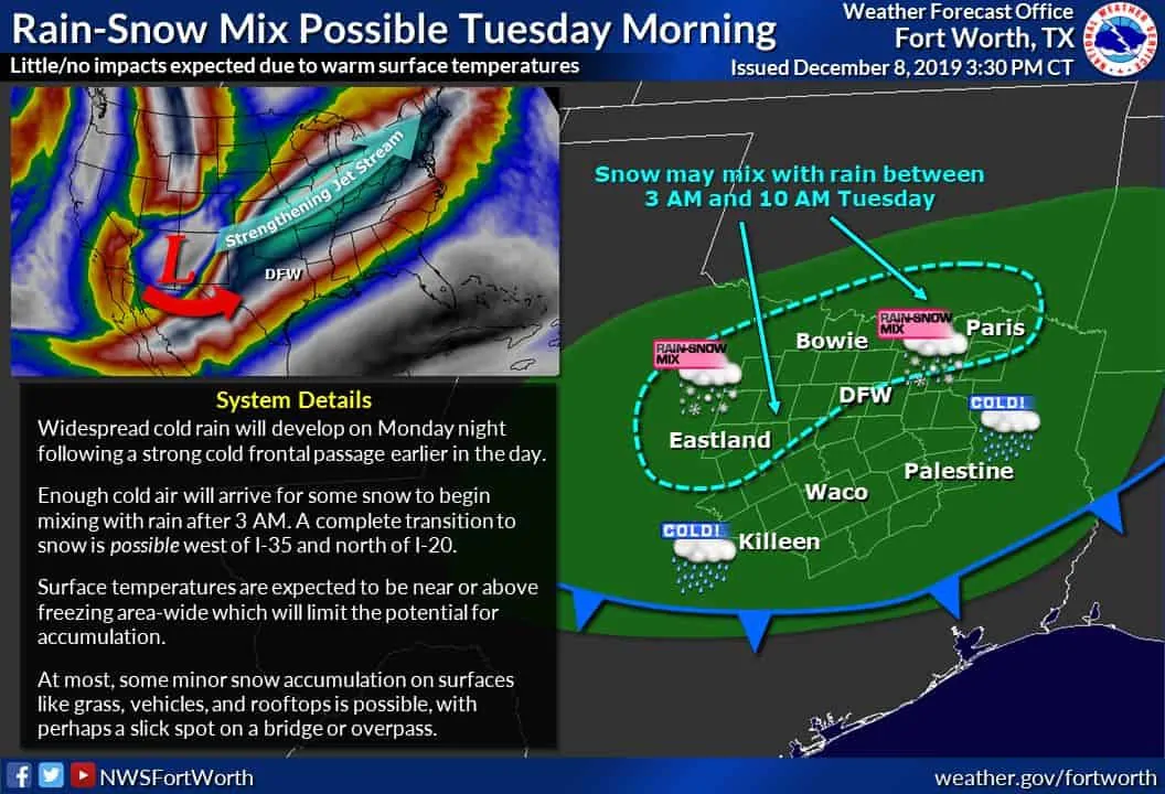
Now for the part of the forecast where most of y’all are curious about. Frigid air aloft in conjunction with colder temperatures advecting in from the north Tuesday morning may allow rain to mix with or completely change-over to snow in northern portions of the Permian Basin, the Big Country, Texoma, and parts of North Texas. That does include western and northern portions of the D/FW Metroplex. As usual, the D/FW Metroplex seems to be the dividing line.
These scenarios are difficult to forecast as any downward or upward trend in temperatures will result in significant changes to the forecast. They’re hair-pulling, challenging, and relatively enjoyable for forecasters as a level of skill and experience is required. Let’s be honest – snow is such a rarity that its fun to deal with in the southern United States.
Let me be abundantly clear – this is not expected to be a significant winter weather event. This is not a case where we expect impassable roadways or copious snow accumulations. Minor snow accumulations are possible in some spots of the regions mentioned above on Tuesday morning.
Temperatures on Monday will be in the 70s, so ground temperatures themselves will be warm. Warm ground temperatures combined with surface temperatures hovering right around freezing Tuesday morning will both work against snow accumulations. Yet we’ve seen plenty of events over the years where brief periods of heavier snow can overcome those unfavorable factors.
Unfortunately, we usually have to wait until we’re within 12-18 hours before we can pin down any areas of higher snow accumulation. Again, we’re not explicitly forecasting more than a dusting or perhaps a quarter-inch of snow on elevated surfaces, but it is something we’ll watch. Regardless, anything that does manage to accumulate will melt by Tuesday afternoon. Sorry kiddos – this doesn’t look like a ‘snow day’ right now.
Mother Nature does have a tendency to throw a few surprises at us, and I will be honest, some weather models are more aggressive than others in the snow department. There is a low, but not zero, chance that we may have a slightly more impressive snowfall event set up for some folks Tuesday morning. It is also worth mentioning that if sleet were to become involved, we’d have to keep tabs on a few bridges for slick spots.


0 Comments