
With a little over a week to go until Thanksgiving, I’m still wondering where the time went this year. Alas, I suppose that’s a symptom of getting older or staying busy. Anyway, we’ll be watching two upper-level storm systems through Friday. Each will bring the potential of precipitation to parts of Texas, although the second system arriving on Thursday night into Friday will be the more significant of the two.
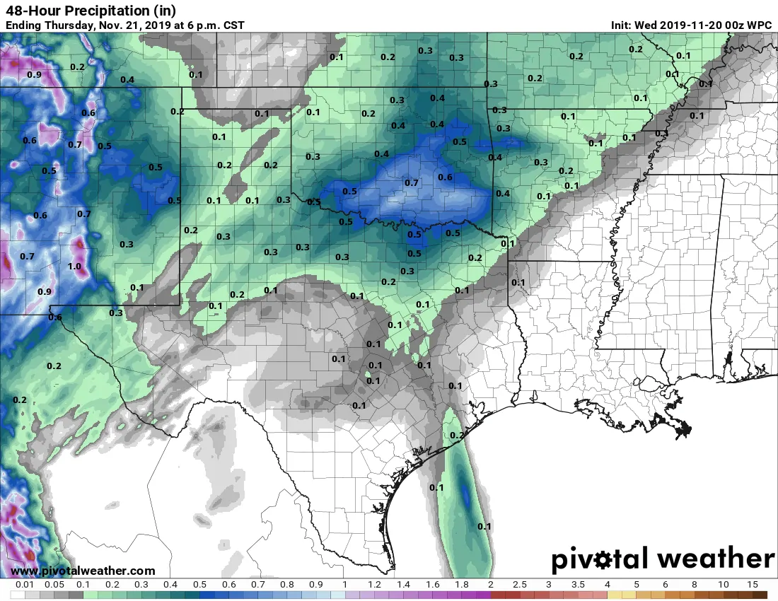
Potential rain totals Wednesday through 6 PM Thursday.
The first storm system to impact Texas will arrive tomorrow afternoon in the Panhandle and West Texas. That system actually contains the remnants of former Tropical Storm Raymond, which lived its life in the Eastern Pacific. There will be no tropical-related impacts whatsoever, but it will pack a little more moisture in as it moves northeast.
Most precipitation from this first system will remain confined to the northwestern half of Texas. More specifically we’re talking about the Borderland, Trans-Pecos, north/northeast up into West Texas, the Big Country, the Texas Panhandle, and Northwest Texas. Overall rain totals will remain on the light side. A few folks may get lucky and get a quick one-half inch of rain with a few stronger thunderstorms tomorrow afternoon.
Severe thunderstorm outlook for tomorrow
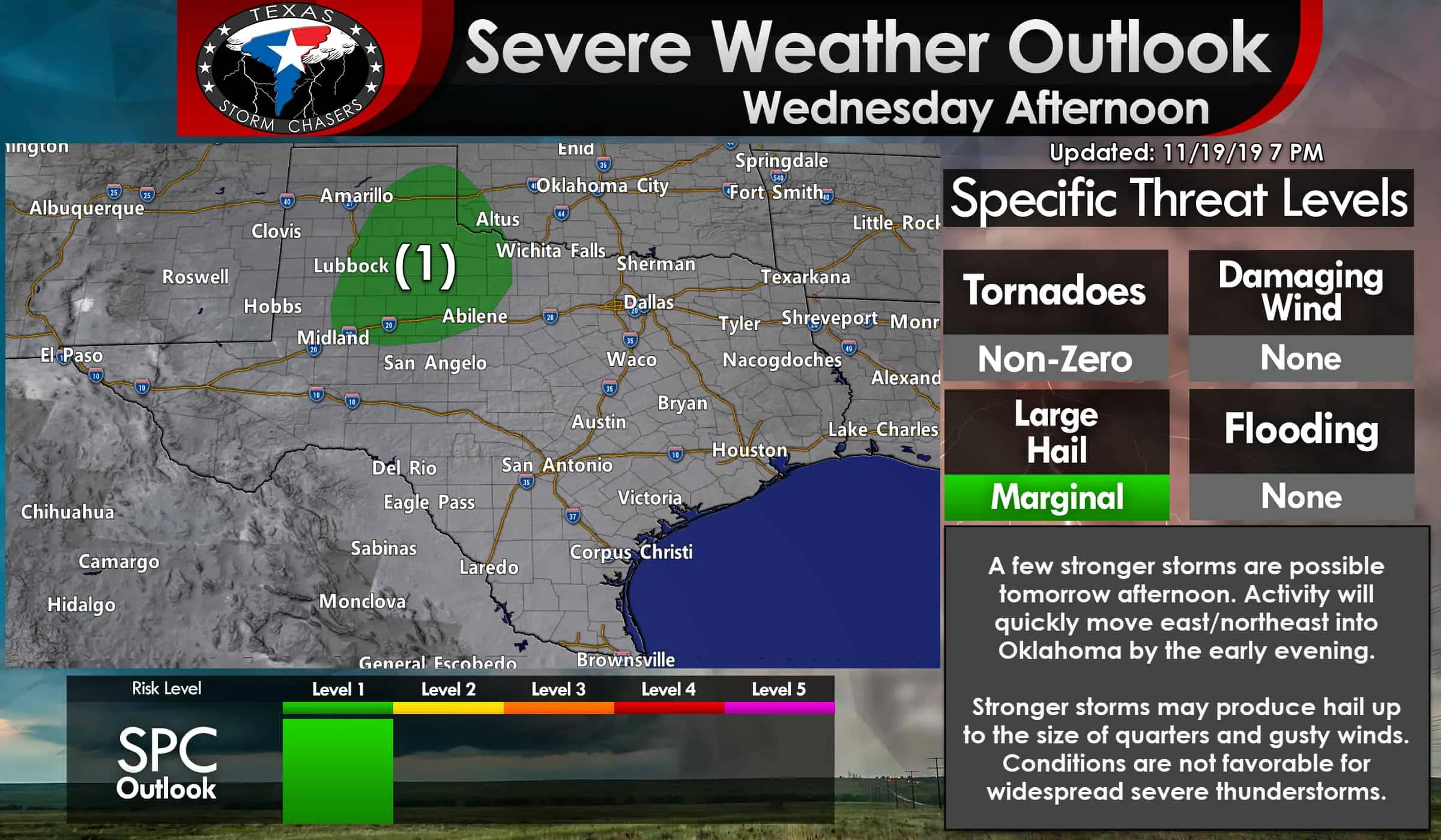
We do have a level one risk of severe weather tomorrow afternoon across the southeastern Texas Panhandle, parts of West Texas (along and east of I-27 and Highway 87), the Big Country, and a sliver of Northwest Texas (west of an Abilene to Throckmorton to Vernon line) up into Southwestern Oklahoma. A level one risk means there is a marginal chance for isolated severe thunderstorms.
Tomorrow’s severe weather risk involves a few stronger storms producing hail up to the size of quarters. Instability values look to be quite limited and not supportive of a more organized severe thunderstorm threat. A fairly typical ‘cool-season’ event where we have plenty of wind shear, but the thermodynamics (instability, surface moisture) are lacking. Gusty winds and brief heavy rain are also possible with stronger storms as they quickly move east/northeast tomorrow afternoon into early tomorrow evening.
Wednesday’s storm system will allow a cold front to slowly sag south to roughly the Red River by Thursday morning. That front will result in showers in the Big Country, Texoma, North Texas, and Northeast Texas by Thursday afternoon. I can’t rule out an isolated stronger storm in Northeast Texas with some small hail during that time frame.
Second system Thursday night into Friday
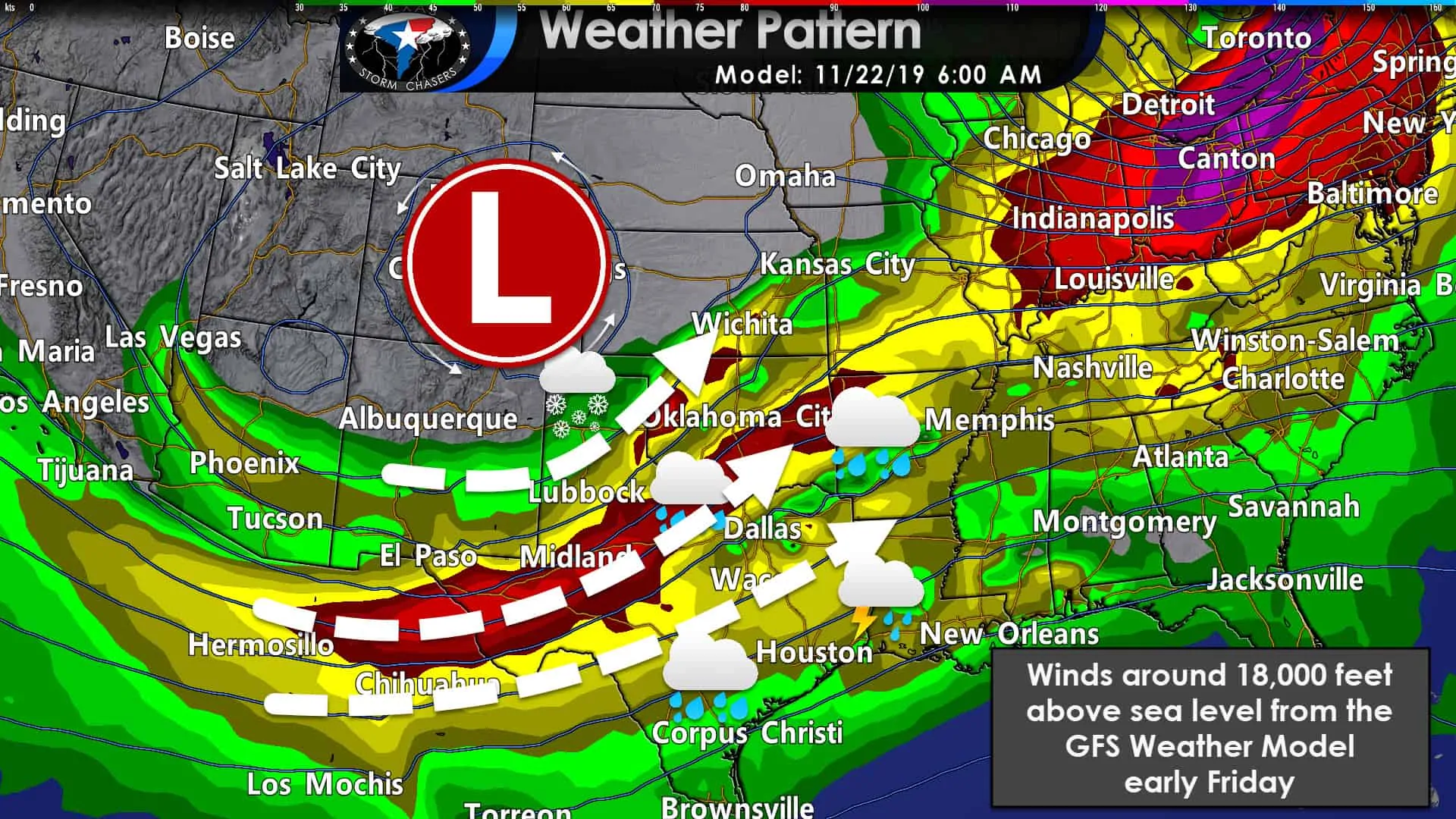
The cold front won’t move much on Thursday as it sits around near the Red River. Temperatures south of the front will be warm and muggy, but that won’t last long once we get into Friday. The aforementioned second upper-level storm system is going to come in swinging from the southwestern United States. That’ll kickstart the cold front and it’ll start booking it south Friday morning and Friday afternoon. By midnight Saturday, the front should be through all of Texas and moving out into the Gulf of Mexico. Gusty northwest winds will occur behind the front on Friday, although with much less obnoxiousness than the arctic front last week.
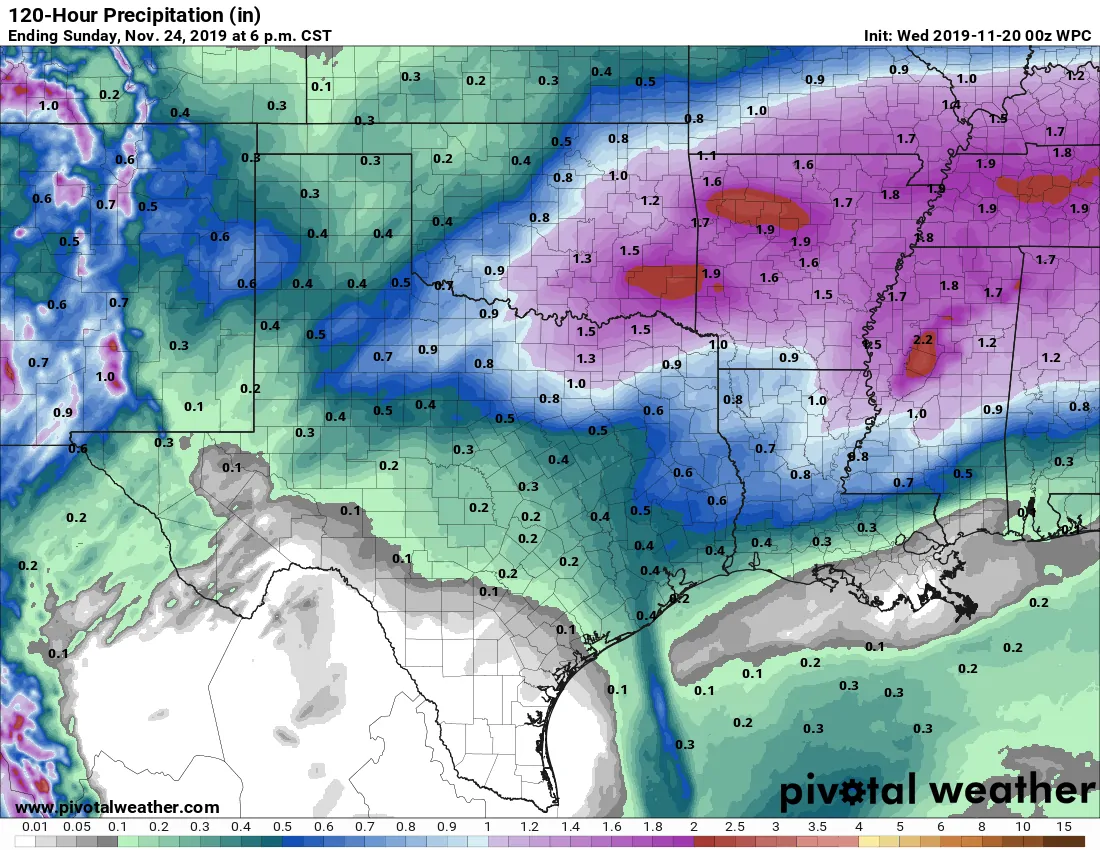
Potential rain totals with the two storm systems (Wednesday through Friday). The weekend will be dry.
A line of showers and perhaps a few storms will accompany the front as it moves southeast on Friday. Rainfall amounts aren’t expected to be all that impressive. Some in Texoma, Northeast Texas, and East Texas could pick up more than one-half inch of rain with the Friday front. The fast pace of the cold front should keep the threat for more organized and severe thunderstorms low on Friday. We’ll keep an eye on it just case, but it doesn’t look like we’ll be dealing with severe storms.
Chances of Rain
Oh snow… yet again for those in the Panhandle
You didn’t think we wouldn’t mention snow chances, did you? Come now… its November after all and the Texas Panhandle has already had multiple winter weather episodes this fall. Why wouldn’t we throw in the chance for another one this week?
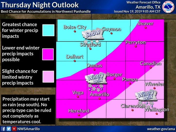
Like most all winter weather chances in Texas, this upcoming one will be tricky to forecast. Uncertainty remains high regarding the temperature profiles in the Texas Panhandle from Thursday afternoon through Friday morning. Cooler than expected temperatures would result in more frozen precipitation, warmer temperatures would result in less. That temperature forecast also makes the ‘freeze line’ positioning fun to deal with too.
Anyway, we’ll probably get a better grasp of this scenario once the weather balloon network samples all the ingredients involved. Those ingredients are currently in California up into the Pacific Northwest. Anyway, the highest chance of accumulating snow at this time is in the northwestern Texas Panhandle. A mix could occur across the remainder of the Panhandle Thursday night into Friday morning, but with diminishing impacts the farther southeast you get from Dalhart to Guymon. Of course, this whole scenario could will easily shift north or south multiple times in future forecasts.
Don’t get mad at the messenger, get mad at the lack of funding for additional upper-air sounding data. That data is what goes into weather models – which then generate a possible scenario based on that initial data.
This Weekend
Dry and nice weather across all of Texas on Saturday and Sunday. Maybe some fog near the coast at times, but otherwise no weather hazards are anticipated. We could be dealing with a significant storm system in the Tuesday-Wednesday frame next week with winter weather and a few severe storms possible. Impacts to travelers on Tuesday and Wednesday are likely at varying times across the eastern half of the United States as an impressive storm system moves east.


0 Comments