A Tornado WATCH has been issued for portions of central and eastern Texas until 6pm this evening. Storms will continue to strengthen late this morning and into the afternoon hours across the region. The WATCH does NOT include the immediate DFW metroplex, but DOES include the Austin metro area, Waco, Bryan/College Station, Tyler, Longview and Nacogdoches and Lufkin. A few tornadoes are possible along with large hail, damaging winds and localized flooding. Have your severe weather safety plan activated and monitor local media outlets for the latest on storms in your area.
South Central Texas counties included in the WATCH: Bastrop, Blanco, Burnet, Caldwell, Comal, Fayette, Hays, Kendall, Lee, Travis and Williamson
Southeast Texas counties included in the WATCH: Brazos, Burleson, Grimes, Houston, Madison, Polk, San Jacinto, Trinity, Walker and Washington
Central Texas counties included in the WATCH: Anderson, Bell, Coryell, Falls, Freestone, Henderson, Hill, Lampasas, Leon, Limestone, McLennan, Milam and Robertson
North Central Texas counties included in the WATCH: Ellis, Kaufman, Navarro, Rains and Van Zandt
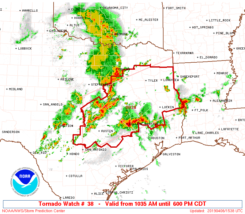
NWS Storm Prediction Center Norman OK
   1035 AM CDT Sat Apr 6 2019

   The NWS Storm Prediction Center has issued a

   * Tornado Watch for portions of
     Eastern and Central Texas

   * Effective this Saturday morning and evening from 1035 AM until
     600 PM CDT.

   * Primary threats include...
     A couple tornadoes possible
     Scattered large hail likely with isolated very large hail events
       to 2 inches in diameter possible
     Scattered damaging wind gusts to 70 mph likely

   SUMMARY...Scattered thunderstorms will continue to intensify across
   the watch area through the afternoon, with a few storms becoming
   severe.  Large hail and damaging winds are the main risks, but a
   tornado or two are also possible.

   The tornado watch area is approximately along and 80 statute miles
   north and south of a line from 50 miles west northwest of Austin TX
   to 45 miles east southeast of Longview TX. For a complete depiction
   of the watch see the associated watch outline update (WOUS64 KWNS
   WOU8).

   PRECAUTIONARY/PREPAREDNESS ACTIONS...

   REMEMBER...A Tornado Watch means conditions are favorable for
   tornadoes and severe thunderstorms in and close to the watch
   area. Persons in these areas should be on the lookout for
   threatening weather conditions and listen for later statements
   and possible warnings.


0 Comments