
Our previous, very detailed discussion from this morning remains mostly on-track regarding the severe weather threat this afternoon, this evening, and overnight. You can read that discussion here. Those wondering about the Texas Panhandle should see our morning discussion. Dense low-level clouds across the eastern third of Texas should continue to quickly erode over the next few hours. That clearing will allow for temperatures to rise and begin to work on weakening the cap.
Click the image for a full-screen version
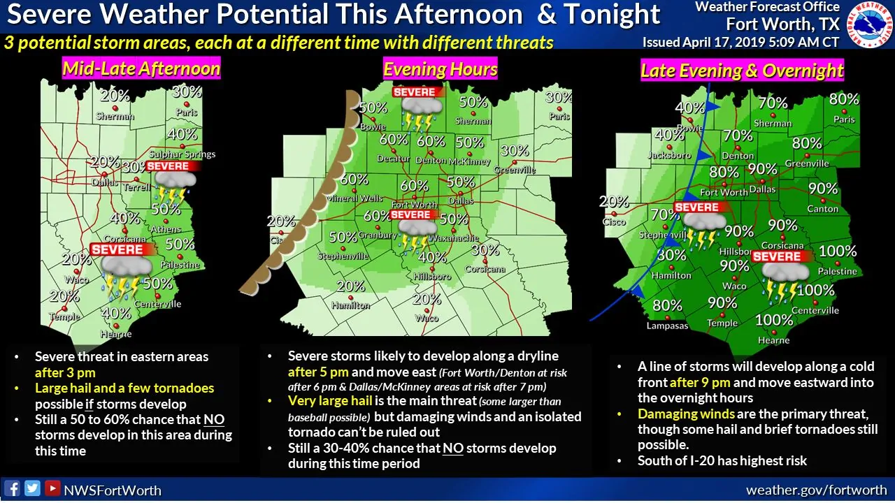
A severe weather threat may develop after 4 to 5 this afternoon across southeastern North Texas into portions of East Texas. Short-range high-resolution weather models have been persistent in developing a couple of supercell thunderstorms. This activity would be well east of the dryline, but within an unstable and strongly-sheared environment. Compared to farther west, this area will have more cloud cover this afternoon and a stronger cap. Storm development is not guaranteed, but if they do develop and can become organized, they would pose a threat for all modes of severe weather – including the threat for a few tornadoes. Storms would move to the northeast. Otherwise, those across East Texas would have to wait until late tonight/early Thursday for a squall line to arrive from the west.
Back to the west in North Texas, we’ll be watching for signs of isolated thunderstorm developing along the dryline. The dryline should be located not too far west of Interstate 35/Interstate 35W. I can’t rule out this occurring as soon as 5PM, but it may hold off until we’re closer to 7PM. It’ll depend on the strength of the cap and if we can overcome some ‘sinking’ air occurring behind the lift occurring farther to the east. We may only see one or two storms from this round, but if they form, they could drop very large hail. Isolated tornadoes cannot be ruled out, particularly if we have discrete supercells ongoing after 8 PM when low-level wind shear increases. Storms would move to the northeast.
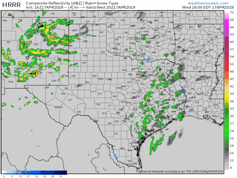
16Z HRRR: Simulated weather model radar from 3 PM this afternoon through 5 AM Thursday. This is only ONE model from ONE model run. Please use it for practical timing purposes only and don’t fixate on exact storm locations. We could see more or less storms than shown along the dryline this evening, and this model is not guaranteed to be right.
Finally, we get toward the early evening hours. We may start to see a line of showers and storms fire up around 8 PM in the Concho Valley. We except rapid thunderstorm development over the following few hours across the eastern Big Country, eastern Concho Valley, and Edwards Plateau. Individual storms would move off to the northeast – while the line itself would be moving to the east.
By 12-2AM Thursday we expect a line of storms to impact the I-35 corridor from the D/FW Metroplex (perhaps all the north to Sherman) all the way south to Laredo – including most everyone in Central Texas and South-Central Texas. The strongest storms in this squall line could be producing damaging straight-line winds up to 70 MPH, hail up to the size of golfballs (perhaps a bit larger if we get embedded supercell structures), and brief tornadoes. Heavy rainfall could cause localized flooding.
That squall line will move east across the eastern third of Texas Thursday morning. Damaging straight-line winds, hail, and brief tornadoes are possible with the most intense storms. Localized flash flooding will become an increasing threat as well. It could be a messy morning commute for Houston in the rain/storm department.
The good news? Easter weekend is looking like it’ll be quiet in the weather department. We’ll be chasing this afternoon and evening, so this will likely be my last detailed blog update until late tonight. Tune in to local television meteorologists and the National Weather Service for severe weather coverage later on today (they both do excellent jobs at it!). You can also keep track of the storms using our interactive weather radar here on our website or in our free mobile app.


0 Comments