
It’s been a rowdy night across West Texas and Northwest Texas. Most storms have remained below ‘severe’ limits in the hail/wind department, but they’ve certainly been loud. We did have storms with hail move through Andrews late last evening along with flash flooding on Highway 180 from Seminole east toward Lamesa. Brief tornadoes occurred just southeast of El Paso (weird…) and near Aspermont yesterday. We haven’t heard of any significant damage reports, so that’s good news. Those thunderstorm chances will begin shifting farther south and farther east today, tonight, and especially on Wednesday.
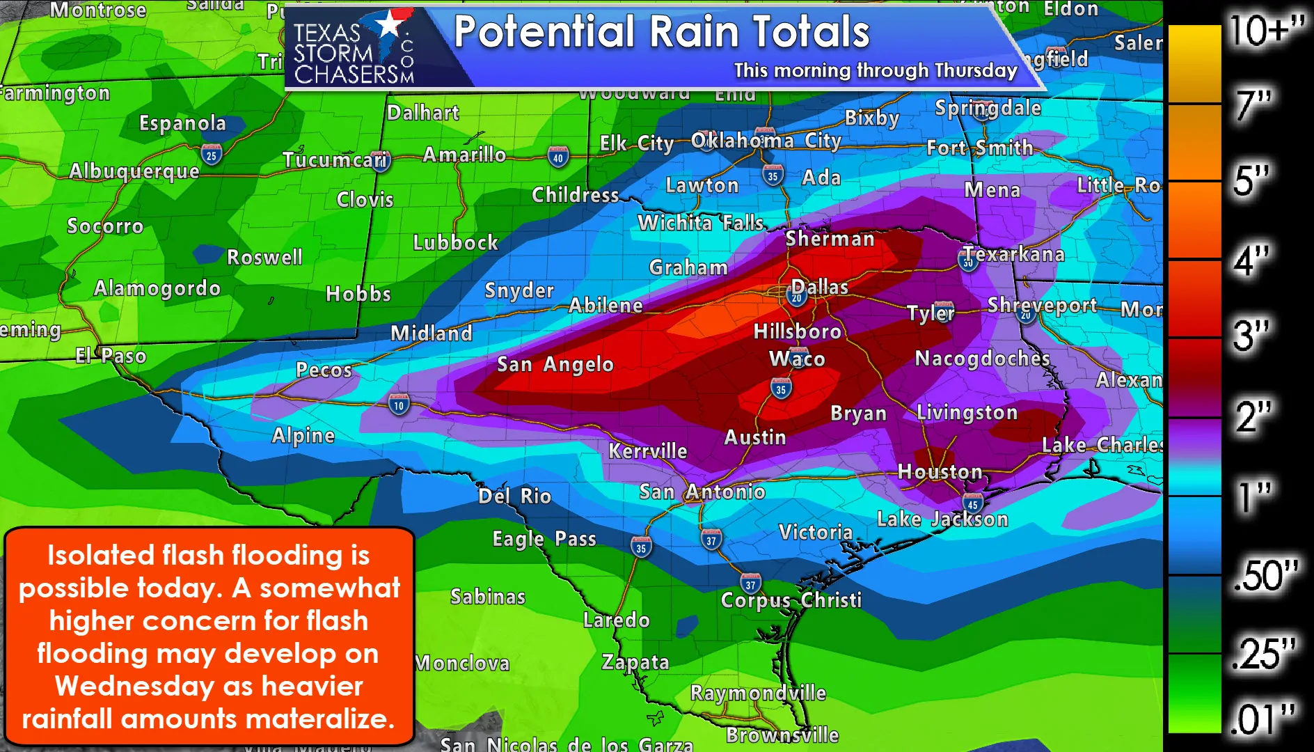
I want to focus first on the rain expected over the next couple of days. That’ll be by far be the most widespread impact experienced versus severe storms. This graphic includes expected rainfall totals from this morning through Thursday. An axis of heavier rain totals are expected to set up shop just north of a near stationary cool front late tonight and on Wednesday. Rain may not be constant during that whole period, but ingredients are set to support some multi-inch rain totals.
The axis of heavier rains could still shift north or south some, but someone will probably be getting over 4-5 inches of rain in the next two days. Regional rain totals from the Concho Valley, Hill Country, North Texas, Central Texas, and East Texas ranging from 1 to 3 inches. We will have to monitor for an enhanced threat of flash flooding wherever that heavier rain axis sets up. Isolated flash flooding will be possible on a large-scale, especially in urban areas and in the typical low-lying trouble spots.
In the extended range, we will have to look at the rising river and lake levels in and downstream of areas that receive heavy rains over the coming days. Rivers are already elevated in East Texas, and Basins out along I-35 and into the Big Country, Concho Valley, and Hill Country will likely be climbing by the weekend. The West Gulf River Forecast Center (WGRFC) will be issuing the forecasts for all the rivers (and their associated flood potential).
Depending on if we see training storms tonight and on Wednesday (those that keep moving over the same areas), we may need to beef up some rain totals on a small-scale basis. I believe we will have some flooding issues develop, but we can hopefully keep them more localized/isolated, but nothing good happens when you get 5+ inches of rain in a few hours (if that indeed is what happens).
Today’s Severe Weather Outlook
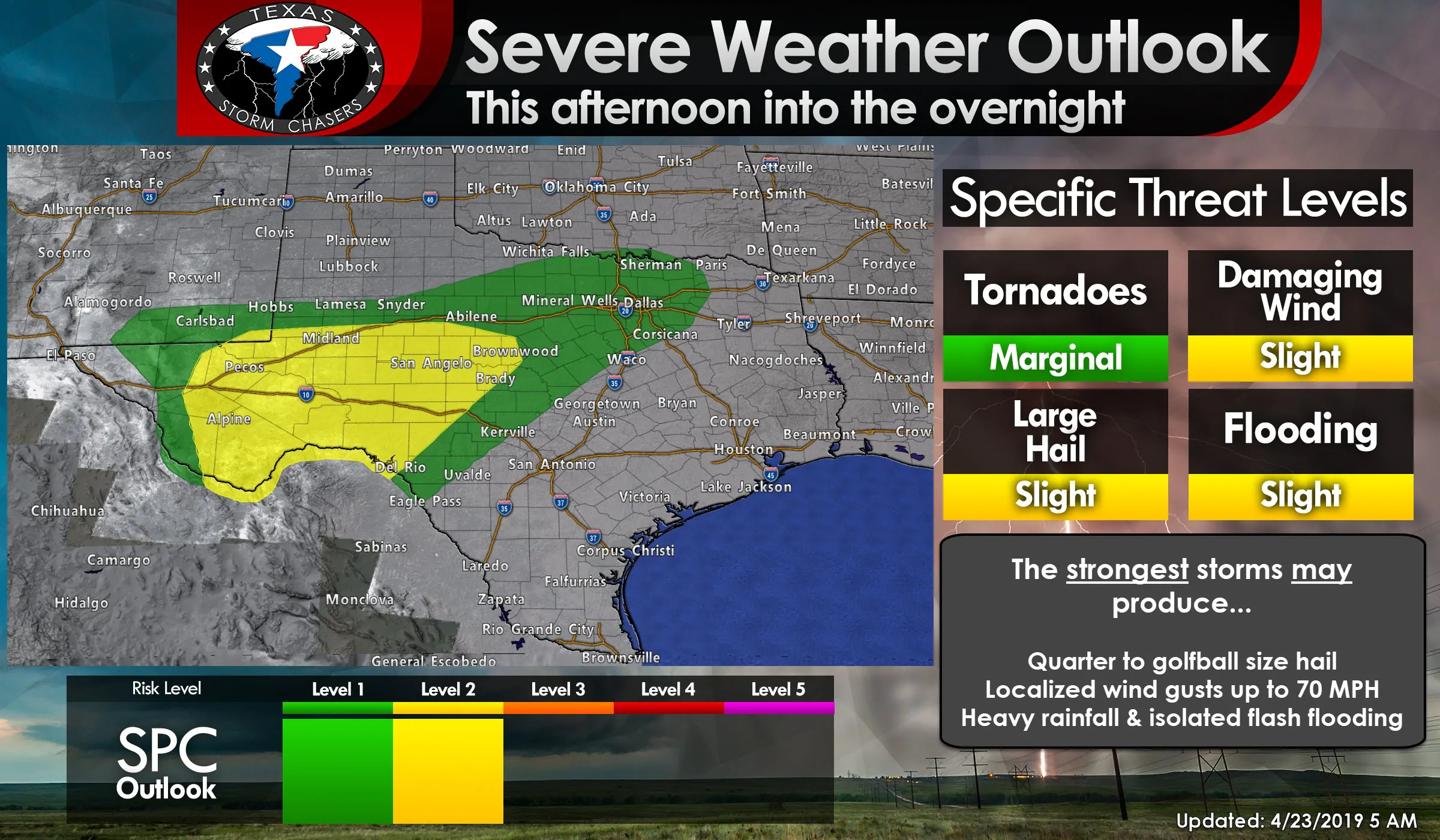
Click image for full-screen version
Isolated to scattered strong to severe thunderstorms will be possible this afternoon, this evening, and overnight from the Permian Basin eastward into the Edwards Plateau and north/northeast into the Big Country and North Texas. Storms will generally move east/northeast. The strongest storms, meaning the most intense, may produce hail up to the size of golf balls and localized wind gusts between 60 and 70 MPH. Most storms will not be that intense, although the number of storms will be increasing this evening and overnight. As mentioned above we will have to keep an eye out for isolated flash flooding.
Wednesday’s Severe Weather Potential
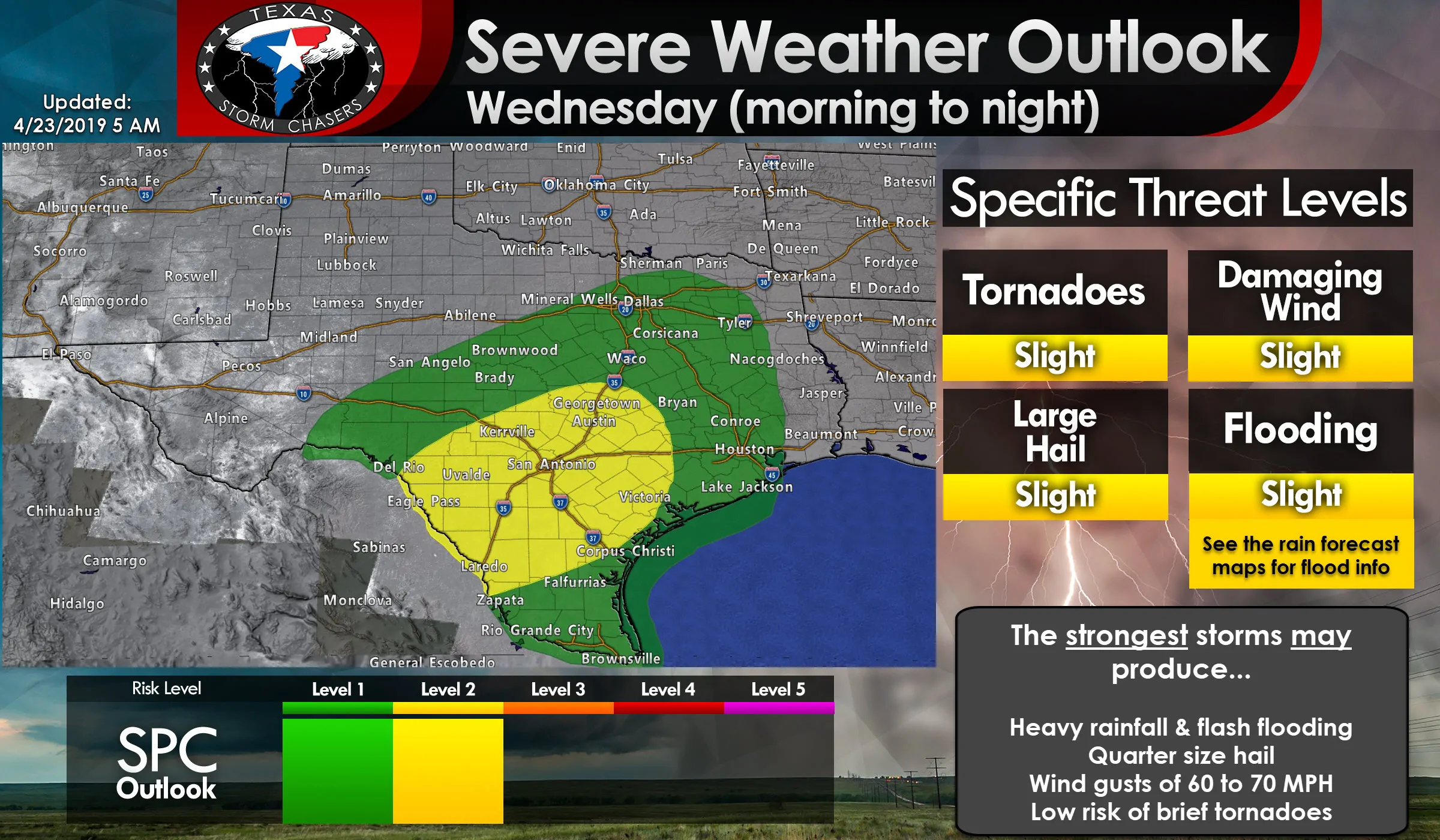
Click image for full-screen version
The risk for stronger thunderstorms will shift east on Wednesday. A level 1 and 2 risk includes the Concho Valley, Edwards Plateau, South Texas, Rio Grande Valley, Coastal Bend, Coastal Plains, Southeast Texas, Brazos Valley, Central Texas, and North Texas. This is not a case where we can provide a clear-cut forecast 24-36 hours out due to the nature of the ongoing storm system. There’s a lot of moisture, not much of a cap, and a barely-moving cool front. Those factors mean the atmosphere can get overturned easily and result in ‘busted forecasts’.
However, there are indications in some weather model guidance that we may have a squall line on Wednesday. That line of storms could be underway by late morning across the eastern Concho Valley and Hill Country. It would move east across the Interstate 35 corridor across Central Texas south into South Texas during the afternoon hours, making its way into the Brazos Valley by the late afternoon, and pushing into the Coastal Plains and Southeast Texas by the early evening hours.
Should a squall line materialize we’d have to keep an eye out for localized damaging winds of 60 to 70 MPH along with brief tornadoes. Hail would be possible, but not as much of a concern due to the storm mode and a more moisture-rich airmass (that favors heavier rain versus big hail). Heavy rainfall would be likely with the storms, but hopefully, their decent eastward movement would limit the time they sat on one area. Still, at least an isolated flash flooding threat would be possible. Any isolated storms out ahead of that squall line (conditional on them actually forming) would have a low-end threat for a tornado.
A side note: Wet soil conditions would result in an increased threat for uprooted trees with higher winds. We saw that with the storms last Thursday morning in the Brazos Valley and East Texas.
We’ll refine the overall storm forecast for tomorrow as we get through today. If the atmosphere is able to be overturned that would lower the threat for more numerous severe storms. That would make the coming days much more of a hydrological issue versus a severe convective nature.
The good news is the storm system will be moving east of Texas on Thursday – meaning a bit of quiet weather. We’re approaching May though, so don’t bet on it staying quiet for too long. Perhaps we’ll get lucky and have another nice weekend? 🙂
Time for some FAQs!
Is it a guarantee it’s going to rain at my house? Nope.
Is it for sure going to hail and/or is a tree going to fall on my house? Nope.
But… I have a 90% chance of rain today and I didn’t get any rain. BUSTED FORECAST! (Nope, you’re just the minority that didn’t get rain.)
Is this going to be like earlier this month with big tornadoes? At this time this doesn’t look like anything near the event that produced significant/long-track tornadoes in East Texas earlier this month.
Is there going to be giant hail? I can’t completely rule it out (even if its unlikely), but most hail sizes should remain below two inches (unless we get an overperformer) in the strongest storms. Most storms won’t produce large hail at all.
Do you like socks? I do enjoy a nice pair of black socks with my tennis shoes. Socks and sandals are a no go.
Are you storm chasing today? We may venture out in Texoma or North Texas this evening if we see an opportunity for photography, but neither today or Wednesday look like ‘chase days’ in terms of photographic material.


0 Comments