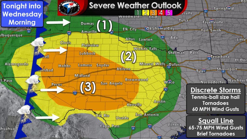
A tornado watch will likely be issued in the next few hours for the Davis Mountains, Permian Basin, and portions of West Texas. Inital thunderstorm development is possible by 5 PM. Those inital thunderstorms may be supercellular with a risk of very large hail and tornadoes. These storms could produce dangerous severe weather. Later this evening we anticipate additional thunderstorms will develop in eastern New Mexico. Those storms will grow upscale into a squall line that will move east into the Texas Panhandle, West Texas, and Permian Basin. That line of storms will move east into Northwest Texas, the Big Country, Concho Valley, and the Edwards Pleauteu late tonight. Storms will move into North Texas and the Hill Country by 3-5 AM. We’ll be watching for damaging wind gusts and brief tornadoes with the squall line overnight, and that’ll likely become the more widespread severe weather threat compared to this afternoon’s discrete storms.
Mesoscale Discussion 0180
NWS Storm Prediction Center Norman OK
0310 PM CDT Tue Mar 12 2019
Areas affected…Southeast New Mexico into portions of West Texas
Concerning…Severe potential…Tornado Watch likely
Valid 122010Z – 122215Z
Probability of Watch Issuance…80 percent
SUMMARY…Isolated supercell development is possible in the next 1
to 2 hours. Any storms which develop will pose a threat for
tornadoes and very large hail.
DISCUSSION…Thick cloud cover and fog which has limited low-level
heating for much of the day has started to dissipate over the last
few hours everywhere except southeast New Mexico. These cloud breaks
have allowed surface temperatures to increase into the mid 60s. In
addition to surface heating, gulf moisture has advected
northwestward through the day with surface dewpoints in the low 60s
near the New Mexico border. This has led to MLCAPE around 1500 J/kg
in southeast New Mexico extending southward toward Big Bend National
Park. A bit more surface heating may be possible before storm
initiation, but low-to-mid level ascent has already started to
arrive and storm initiation is likely soon.
The 18Z MAF sounding showed a favorable wind profile with deep layer
shear around 50 knots and effective SRH around 275 m2/s2. This wind
profile is expected to become even more favorable into the early
evening with 700mb flow strengthening from 35 knots to near 60 knots
after 00Z and effective SRH increasing above 500 m2/s2.
The biggest question will be whether isolated supercells can develop
ahead of the Pacific front this afternoon. The HRRR continues to
develop a few isolated storms in southeast New Mexico this afternoon
with surface temperatures near 70 degrees. If isolated supercells do
develop in this environment, the thermodynamic and kinematic
environment will be extremely favorable for tornadoes. However,
quick storm motion may quickly take storms out of the better
instability which may limit the opportunity for low-level
mesocyclone organization within this favorable environment. Farther
south into the Trans Pecos (where GOES16 visible imagery shows a
thickening cumulus field), if any storms can develop they will
remain in better instability for a longer period after initiation,
making the threat for tornadoes more likely. However, the threat for
isolated storms ahead of the Pacific front in this area appears less
likely as the better forcing remains farther north.
Independent of earlier storm development, numerous storms are
expected to develop along the Pacific front this evening and quickly
become linear. The primary threat from these later storms will be
wind, especially given the strength of the lower tropospheric flow.
A tornado watch is likely at some point, but it remains unclear
whether it will be needed for earlier supercell development this
afternoon or frontal development this evening.
..Bentley/Thompson.. 03/12/2019


0 Comments