
Not much has changed with the forecast this evening. We do note that evening weather model data, specifically the high-resolution for tomorrow morning, has become a bit more aggressive with the severe weather parameters. That helps increase our confidence in the potential of large hail and localized damaging wind gusts in North Texas and Northeast Texas tomorrow morning.
This will be a morning event, not the typical afternoon or evening storms some may be accustomed to. There is a low threat for tornadoes, with the ‘relative highest’ threat zone across Northeast Texas. Overall the tornado threat is low, but present. Large hail and localized damaging winds should be the primary threats by far.
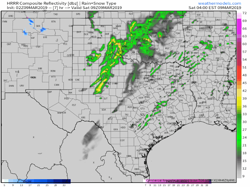
02Z HRRR: Simulated weather radar from 3 AM Saturday to 12 PM on Saturday. This is only a simulation and the exact placement and timing of storms will probably differ.
We could see scattered showers and even storms across the Big Country, Northwest Texas, and North Texas overnight. Some of this activity may produce hail, but the overall severe weather threat seems to be fairly marginal. Our main show will begin after 5 AM.
A line of thunderstorms will quickly develop from near Sherman to Granbury between 4 AM and 6 AM Saturday. While the pre-dawn timing would suggest otherwise, we are expecting ingredients to be favorable for organized thunderstorms. The exact timing of storm development will dictate who all in North Texas actually gets impacted. Earlier development would result in storms firing up farther west. Later and we may only see eastern parts of the D/FW Metroplex impacted.
Large hail could be a threat pretty quickly given lots of instability aloft and cold temperatures. Winds a few thousand feet off the surface will be screaming out of the south/southwest at 65 to 75 MPH. When storms grow upscale into a squall line we’ll likely start to experience some 50 to 70 MPH wind gusts in the stronger storms.
Storms will move east/northeast quickly and should be east of the D/FW Metroplex by 8 AM. Those in Northeast Texas and northern sections of East Texas will be under the gun between 7 AM and noon. Some of the storms in the squall line may exhibit supercelluar characteristics. That would enhance the potential of damaging hail and stronger wind gusts.
Some of the model data is being more aggressive with low-level wind shear across Northeast Texas in the morning. That means we will have to watch for a risk of a few isolated tornadoes. Large hail is still expected to be the primary threat.
Most of the severe thunderstorms should be moving out of Texas by lunch-time. We’ll likely have a thin line of showers and storms continuing across East Texas southwest into the Brazos Valley tomorrow afternoon. Some of those storms may produce hail up to the size of quarters, but dynamics aloft and low-level wind shear will both be weaker and not as supportive of a more substantial severe weather threat.
Those west of a surface dryline will enjoy above-average temperatures (70s and 80s) with west winds between 15 to 30 MPH. Relative humidity values will drop below 25 percent along and west of Interstate 35. Elevated to near-critical fire weather conditions are expected across the western half of Texas tomorrow afternoon.
The key message I want to emphasize is we are expecting fast-moving severe thunderstorms between 5 AM and Noon across North Texas and Northeast Texas. The highest potential for large hail, damaging winds, and isolated tornadoes will be in eastern North Texas and Northeast Texas. Do not let the time of day fool you. Some of these storms will likely pack a punch.


0 Comments