
A new severe thunderstorm watch will likely be issued for Northwest Texas soon. A line of strong to severe thunderstorms continues to make progress eastward into Northwest Texas, the Big Country, and Concho Valley. The strongest storms in the Concho Valley and Big Country are capable of producing 60 to 75 MPH winds and brief tornadoes. Storms entering Northwest Texas may produce wind gusts of 50 to 65 MPH, mostly due to the fact winds just a few hundred feet above the surface are 60+ MPH. It doesn’t take much to get those stronger winds down to the surface. For those wondering, yes we probably will see a severe watch issued for portions of North Texas down the road. Those storms are still about 1.5 to 2 hours away from entering western North Texas.
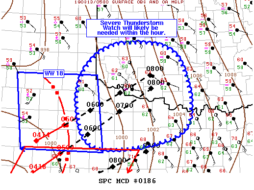
Mesoscale Discussion 0186
NWS Storm Prediction Center Norman OK
1231 AM CDT Wed Mar 13 2019
Areas affected…Northwest TX…Southwest OK
Concerning…Severe potential…Severe Thunderstorm Watch likely
Valid 130531Z – 130630Z
Probability of Watch Issuance…95 percent
SUMMARY…Ongoing well-organized convective line is expected to move
out of Severe Thunderstorm Watch 18 by 06Z. A downstream severe
thunderstorm watch will likely be need across northwest TX and
adjacent portions of southwest OK within the hour.
DISCUSSION…Strongly forced convective line currently moving
through the southern TX Panhandle and TX South Plains has
intensified over the past hour or so with severe winds gusts were
reported as it moved through the TX South Plains. Increased
northeastward motion has also been observed during this time as the
orientation of the line has become more orthogonal to the flow
aloft. Current storm motion is around 50 kt, taking the convective
line to the edge of Severe Thunderstorm Watch 18 by 06Z.
Downstream airmass is relatively stable in the low-level but steep
mid-level lapse rates coupled with continued moisture advection and
strong lift should still allow for enough instability to support
deep convection, particularly given the already organized structure
of the convective line. Recent KLBB radar imagery has shown low
reflectivity behind the line, suggestive of strong
subsidence/rear-inflow. Very strong fall/rise pressure change
couplet observed is also evidence of a strong, well-organized
system. As such, a downstream severe thunderstorm watch will likely
be need across northwest TX and adjacent portions of southwest OK
within the hour.


0 Comments