
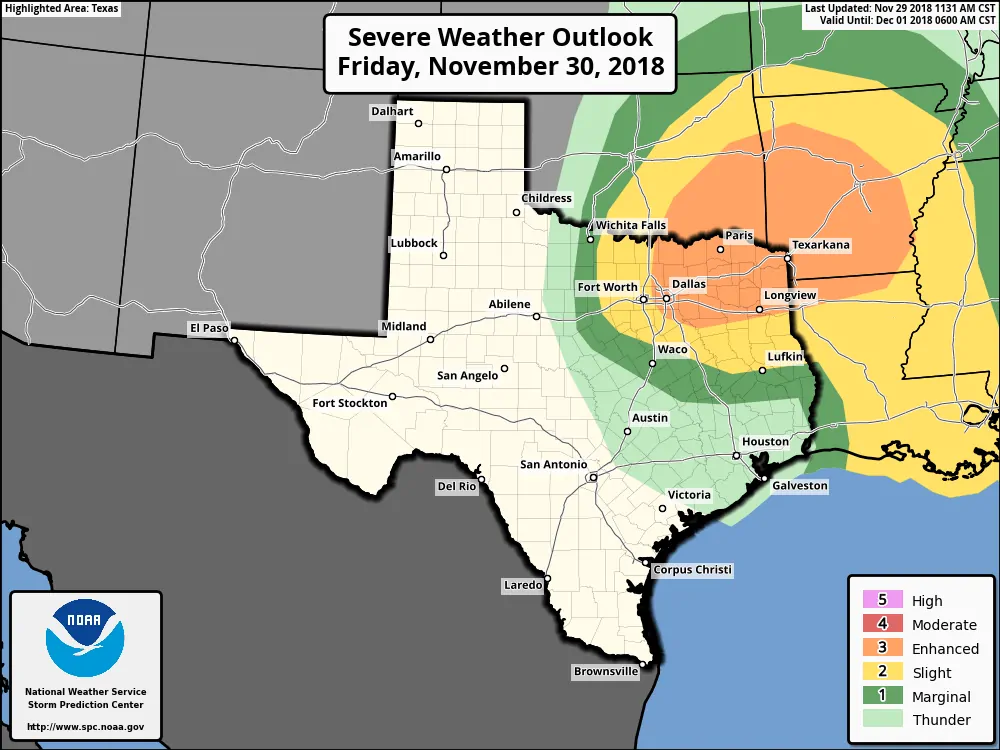
Just a brief evening update on the potential for severe weather tomorrow (Friday) evening. Earlier today, the Storm Prediction Center upgraded parts of north central, northeast Texas to an Enhanced (Level 3) risk of severe weather Friday afternoon and into the evening/overnight hours. In addition to the upgrade, the threats were shifted slightly west to encompass more of north central Texas including parts of the DFW metroplex. As it stands currently, the DFW metroplex is bisected by a Slight Risk (Level 2) for the western half and the Enhanced Risk (Level 3) across the eastern half. Threats within both the Slight and Enhanced Risk areas include damaging winds, large hail and the potential for tornadoes. Of course the big question remains…will it actually happen. The answer is both yes and no. Yes, the chances are much higher for seeing severe weather for points east of the DFW metroplex. That has been the forecast all along. What’s new is the threats further west which will likely turn into an “all or nothing” scenario depending on several factors including moisture return, the timing and strength of the approaching upper level system, and the amount of instability that can be realized by tomorrow afternoon. As mentioned yesterday, this may become one of those situations where forecasters will not have a good handle on what will actually happen until hours before. This morning, most all of the short-range models were developing storms east of the DFW metroplex with little to nothing within the metroplex itself. By late this afternoon, a few of the models have picked up on the chance for storm development along the dryline just west of DFW around the 5-7pm timeframe as the dryline/frontal boundary races into the region. However, even if we do see development to the west that moves into the metroplex, due to limited instability across the area, it could still take awhile for the storms to reach severe limits…which may not happen until the storms have moved east of the metroplex. This is a trend which will be monitored closely overnight and tomorrow morning.
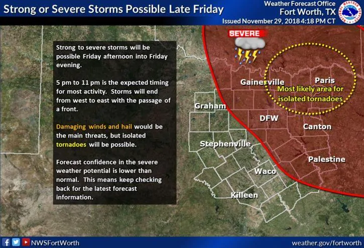
Just for some fun reading, we’ve included the afternoon forecast discussion from the National Weather Service office in Fort Worth. This is a really well written and in-depth discussion of how complex tomorrow’s set-up is. A bit of a nerdy read, but most will pick up on the high degree of uncertainty over how tomorrow’s storms will play out across the area. The takeaways at this time are as follows: If you live east of the DFW metroplex, be on high alert tomorrow evening. Have your weather radios on and have a way to receive warnings if you’re out and about. Review your family’s severe weather safety plan. If you live in or around the DFW metroplex, know that this could be an all or nothing situation tomorrow, but be prepared anyway just in case.
The primary forecast concern is the severe weather potential on
Friday afternoon/evening. Over the last 12-24 hours, model
guidance has slowed down the speed and deepened the track of the
potent upper level low that is now crashing onshore in
California. This has implications on the severe weather risk area
across North and Central Texas with more of the CWA in play for
severe storms as the risk area shifts a bit westward.

This upper level system will feature strong dynamic forcing for
ascent as the trough rotates into a negative tilt and the
diffluent exit region of an impinging 120 knot jet translates into
the area. The degree of forcing this system will generate is on
the upper end of what we typically see around here, and therefore
it creates a great deal of uncertainty in the forecast. The reason
for this is because dynamic forcing for ascent often primes the
atmosphere for convection - meaning it creates a more favorable
temperature and moisture profile for storms. This is critically
important tomorrow, because the airmass in the morning hours will
be rather unfavorable for convection, both strongly capped and
only a very shallow layer of moisture. This probably means most of
the area will experience low cloud cover for most of the day,
thus limiting day time heating and keeping our highs in the 70s.
However, as the forcing arrives into the western zones around mid
afternoon we should see a rapid modification of the airmass. The
capping inversion is forecast to lift and lapse rates will steepen
as the thermal profile cools aloft. What shallow moisture is
available is also lifted to moisten the profile and the strong low
level flow off of the Gulf will result in good low level moisture
flux and precipitable water values rising a third to half inch in
just 6 hours. This of course is all what the models tell us, and
we know they`re not perfect, especially when rapid airmass
modification is taking place, which is why the uncertainty is
higher than normal with this forecast. Still we do believe that
conditions should become favorable for severe convection by the
late afternoon hours over parts of our CWA, but this event may
not evolve as a typical spring-time dryline scenario.

For example, a dryline is evident in the models during the
afternoon, but it appears to transition and behave more like a
Pacific cold front after sunset and sweep eastward across the
region. Convection will probably fire along the dryline/front, but
it may be well after peak heating and just before the 520 pm
sunset. In addition, the best moisture and instability should be
east of I-35 and we may see a spontaneous eruption of scattered
storms in that area by early to mid afternoon well ahead of any
surface boundaries. In any case, PoPs will be highest in the east
during the afternoon with 40 percent advertised there, tapering
down to 10 and 20 percent in the western zones. After sunset, PoPs
will increase remarkably along and to the east of the I-35
corridor, with rain almost a sure bet across the northeastern
zones and far eastern zones. All of this activity should clear
out from west to east by or shortly after midnight.

For the severe weather potential, due to the strong wind shear and
moderate instability (SBCAPE 1000-2000J/KG), all modes of severe
will be possible as supercell structures and short line segments
appear likely. The combination of wind shear and instability
particularly highlights the northeastern zones as the most
favorable region, where isolated tornadoes may occur. Wind damage
will be most probable with line segments and large hail will be
more probable with supercells, however the exact convective mode
is in question. Strong forcing suggests the linear mode will be
dominant, but the parameters point toward supercells. Farther to
the west including the DFW Metroplex (where the severe weather
risk area from SPC was adjusted to include) the severe weather
threat may be an all or nothing type setup. What I mean by that is
that there is a tendency for thunderstorms to take a while to
mature into severe storms or supercells in cool season severe
weather episodes here. This is probably due to the wind shear
overwhelming the young updrafts and the more limited instability.
As a result of the speed at which these storms move, they may
initiate farther west, but may not produce severe weather until
50-75 miles farther east. However, it`s clear the parameter space
supports a slight to enhanced risk of severe weather, but some
storm scale processes may limit or inhibit this threat. At this
time we want to stress that severe weather isn`t a sure bet in all
outlooked areas, that this is different than the typical spring
events, and confidence on the western extent of this threat is
lower than usual due to the rapidly changing modification of the
atmosphere in the afternoon. Please stay updated with the latest
forecast data through the next 24 hours for any changes to our
thinking or confidence.


0 Comments