
A complicated forecast is in the cards regarding severe weather potential both for later today and again on Tuesday. Widespread rain, clouds, residual outflow boundaries, and a weak cap will make forecasting specific targets and time-windows more difficult. Convective-allowing weather models are all over the place, so trying to share a ‘simulated weather model radar’ image would do more harm than good. This is when one has to take a step back and look at the ingredients and try and make a decent forecast from there.
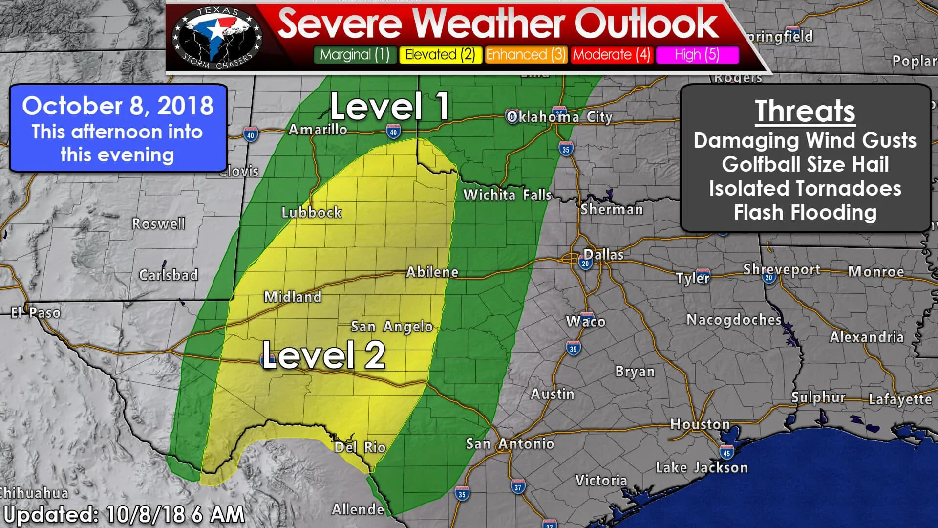
The Storm Prediction Center has placed their standard ‘level 2’ risk of severe weather across the Concho Valley, Permian Basin, Big Country, into West-Central Texas for today. A ‘level 1’ marginal risk surrounds it and includes the Edwards Plateau, the Hill Country, western North Texas, Texoma, and the southeastern two-thirds of the Texas Panhandle. One’s chance of experiencing severe weather within 25 miles is about 15% in the level 2 risk and 5% in the level 1 risk. SPC’s risks are drawn using probabilities.
Initial development and threats
We’ll be watching a few areas for scattered thunderstorm development this afternoon across West Texas south into the Permian Basin. These initial storms may become supercelluar with a risk of large hail and localized damaging wind gusts. I’ve inserted golf-ball size hail, but it wouldn’t surprise me if we saw a few larger stones initially.
Tornado threat?
Low-level wind shear values will be increasing after 5 PM as the low-level jet develops across the region. Outflow boundaries left over from yesterday’s storms along with activity overnight could also enhance low-level shear. Isolated tornadoes will once again be possible today. The highest tornado risk will be from discrete/semi-discrete storms late this afternoon and early this evening. However, brief tornadoes will remain possible even as storms grow upscale into a squall line. The threat of damaging wind gusts will also increase once storms become linear. Those two threats will continue well into the night.
Squall line forms and moves east late tonight with dual threats
A squall line is expected to move east tonight as our upper-level storm system finally begins to make some eastward progress. This line of storms may not organize until late tonight, but it’ll likely bring a light show once it does. By early Tuesday the line of storms may be moving east into Northwest Texas, the Big Country, the Concho Valley, and into the Edwards Plateau. Not all storms in the line will produce severe weather, but some may be capable of producing straight-line winds over 70 MPH and brief tornadoes. Very heavy rainfall and flooding are also primary threats – and may become the most common threat.
Fast forward to Tuesday Afternoon and Tuesday Night
As our upper-level storm system moves east so will the threat of thunderstorms. Tuesday’s severe weather threat still has some questions that we don’t have answers to. A fairly linear storm mode is expected with storms that fire up during the late afternoon and evening hours Tuesday.
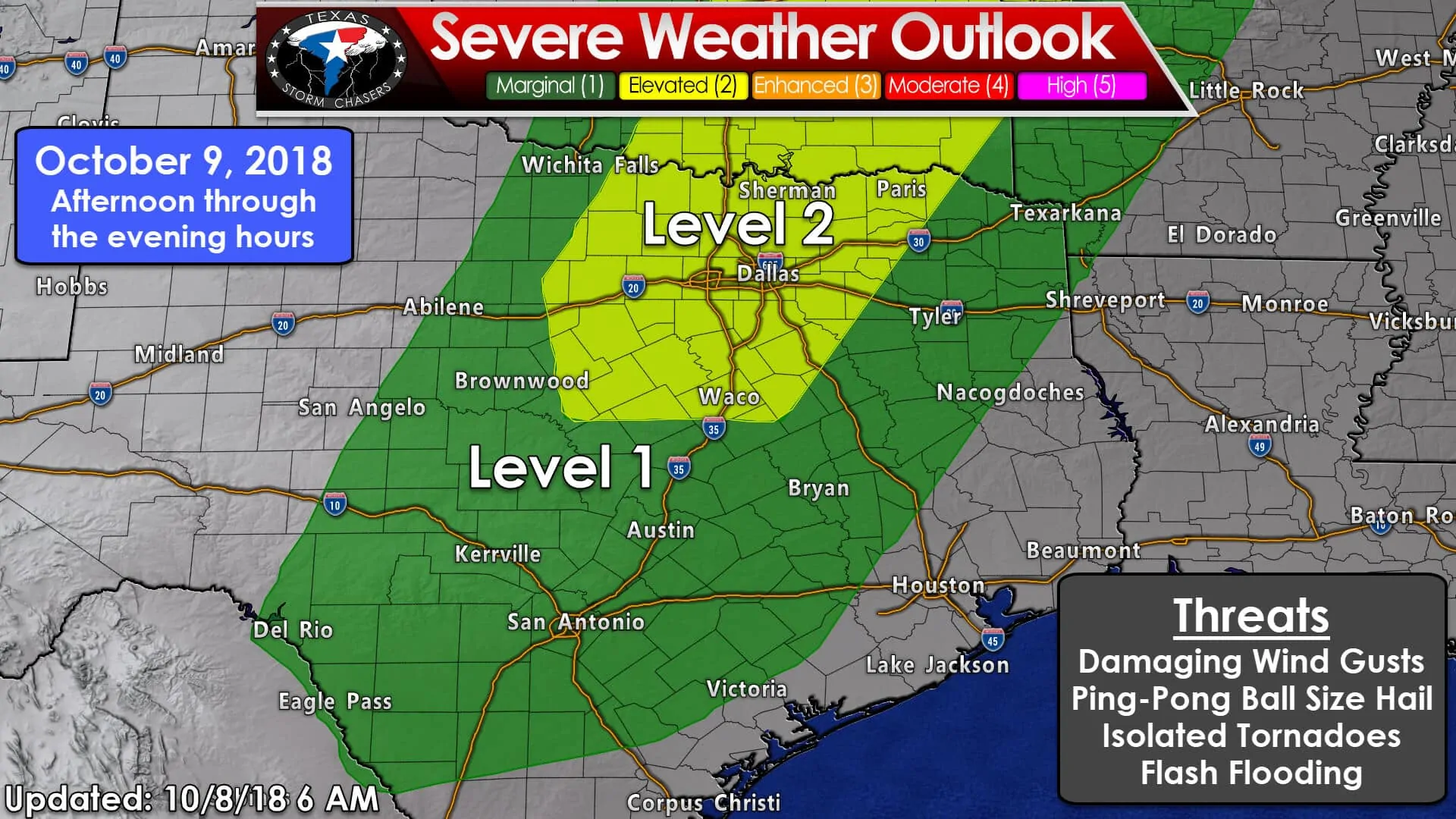
The standard ‘level 2’ risk zone from the Storm Prediction Center includes a majority of North Texas and Texoma. A ‘level 1’ marginal risk is much larger and runs from the Edwards Plateau north/northeast through South-Central Texas, the Hill Country, the Brazos Valley, into eastern portions of the Big Country, and Northeast Texas. These zones will be refined/changed as new data arrives. Keep in mind that today/tonight’s storms and airmass recovery behind them will play a role in Tuesday’s setup. Likewise, the position of the cold front/dryline will dictate the western delineation of the severe weather risk (will it end up moving more slowly east?)
Uncertainties and questions for Tuesday’s storm threat
A big question is how much airmass recovery will take place ahead of Tuesday’s round of storms. Will we see widespread rains/storms/clouds hamper instability? If we end up with some clearing ahead of the dryline/cold front on Tuesday – thus allowing for some sun and destabilization, that would only serve to add some storm fuel. This is one aspect that isn’t entirely known at this point since tropical airmasses generally have weak caps.
Storm mode and threats
What does look fairly on-point is the overall storm mode. Wind profiles aloft certainly favor a linear storm mode – a squall line. A squall line would have a higher relative threat of producing damaging wind gusts and heavy rain compared to large hail and/or tornadoes. However, just because it may look like storms will be linear does not mean ALL storms will be linear. Any storms that fire up ahead of the squall line or any ‘breaks’ in the squall line could have an increased risk of producing a tornado. We’ve seen many events in the past decade that have looked like ‘linear’ events only to have a few storms fire up ahead of the line that goes on to produce tornadoes. Low-level wind shear will be stronger in North Texas (in the level 2 risk) compared to farther south tomorrow, so we’ll have to keep an eye out. Brief tornadoes can also occur in stronger areas of damaging wind gusts in squall lines.
Timing
Given the factors mentioned above, a fairly realistic scenario at this point would be to expect scattered thunderstorm initiation along the cold front/dryline between 3 PM and 5 PM from North Texas north into Oklahoma. This would place storm development west of Interstate 35/35W by 30 to 50 miles. Those storms would probably grow upscale fairly quickly into a broken to a nearly solid line of thunderstorms by 7 PM – at which point they’d be on the doorstep of the D/FW metroplex. Individual storms may tend to move more north/northeast while the line makes slower east progress. Around midnight Wednesday, the squall line would be moving east across Northeast Texas and East Texas while slowly weakening during the early morning hours Wednesday. Understand all that will probably change somewhat as we get through today and get a better idea of how tomorrow’s key players will set up.
Flooding is a primary concern on Tuesday/Tuesday Night
Heavy rainfall and localized flooding are also concerns. Given the heavy rains over North Texas in September soils won’t be able to take too much new rainfall. While I concentrated on severe storm potential in this blog, we’ll likely need to discuss heavy rainfall, flash flooding potential, and the longer term issue of river flooding in a separate blog later today. Remember – flash flooding kills more than any other severe weather hazard.
Additional Rain Totals
Here’s a look at how much more rain may fall today through Thursday. Keep in mind some locations have already seen 4-5+ inches of rain – and places like North Texas can’t handle too much rain too quickly. Additional flooding is likely today, tonight, and on Tuesday. As stated above we’ll likely dedicate a seperate blog post to talk about the flooding risk; both short term and the longer-term river flooding.
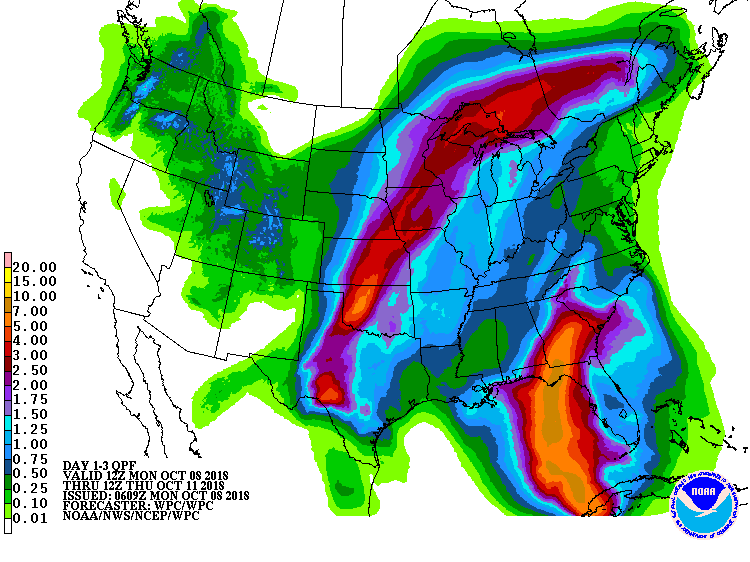
Additional rain possible this morning through Thursday morning.


0 Comments