
A strong cold front for February – not to mention April – will plow south into Texas this afternoon into Saturday. Strong northerly winds and a substantial temperature drop will accompany the front. By this time Saturday, we could see snow and sleet across the Texas Panhandle into Oklahoma. Such a strong front in April will usually bring an attendant threat for thunderstorms. That is the case today across the eastern third of Texas. A strong cap will likely prevent thunderstorms in the west – where rain is needed the most.
Severe Weather Outlook for Today and Tonight
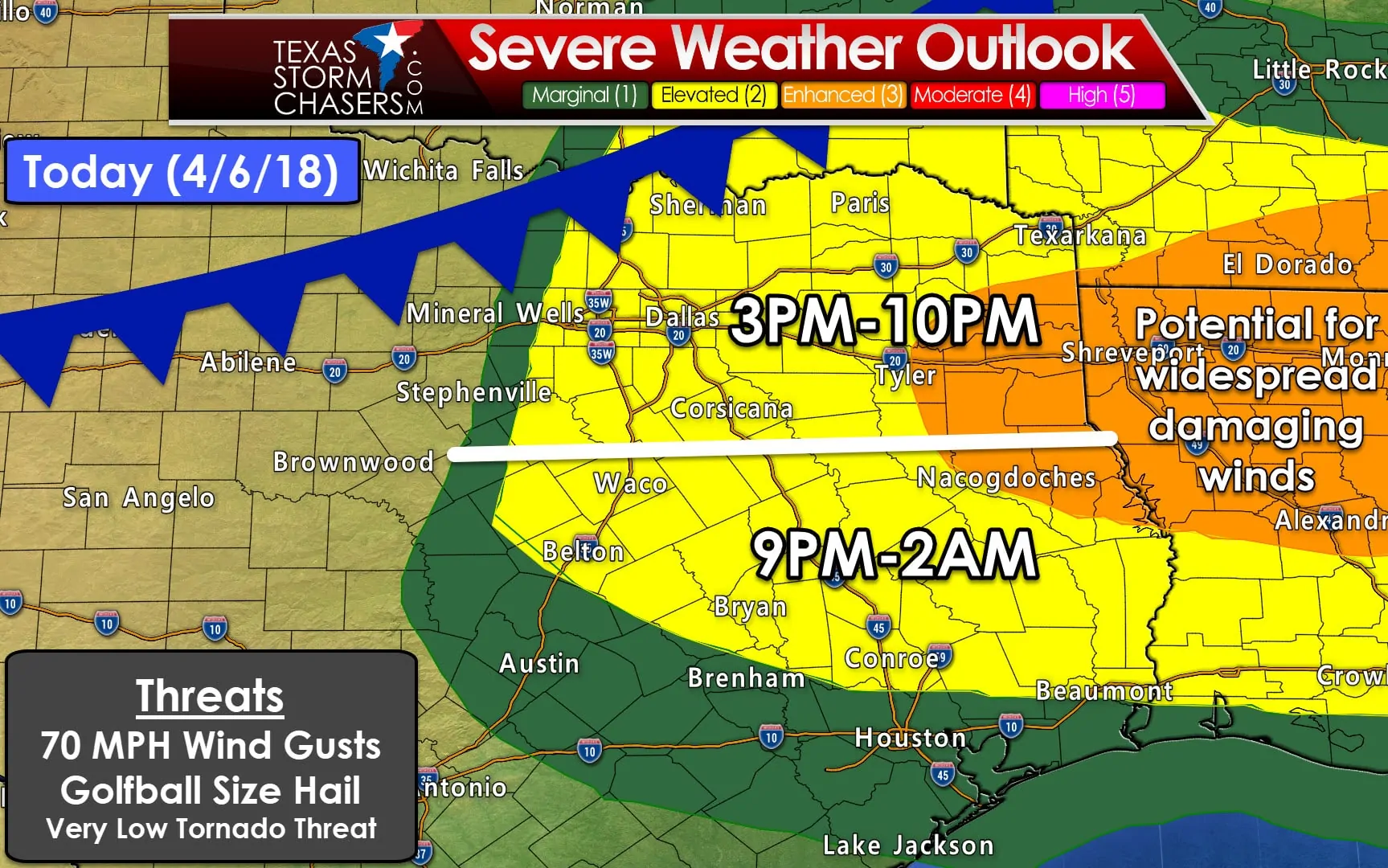
A level one (marginal) risk of severe weather is in effect for a small portion of western North Texas, portions of Central Texas, and Southeast Texas. This zone has a 5% chance of experiencing severe weather within 25 miles of any given point (such as one’s house).
A level two (standard) risk of severe weather is in effect for the eastern half of North Texas, most of the Brazos Valley, and portions of East Texas. This zone has a 15% chance of experiencing severe weather within 25 miles of any given point (such as one’s house).
A level three (enhanced) risk of severe weather is in effect for Northeast Texas and East Texas. This zone has a 30% chance of experiencing severe weather within 25 miles of any given point (such as one’s house). This enhancement has been issued due to the potential of more numerous damaging wind reports. It is possible the most widespread wind damage remains east of the Texas/Lousiana state line.
Don’t become fixated on the exact placement of each risk zone. Pay attention if you are in or near the severe weather risk today. Storms don’t read maps and certainly don’t care where lines are drawn on said map. This outlook will be updated around 8 AM and 11:30 AM. You can see those updates as they’re issued over on our severe weather outlook page here.
Threats
The dryline will likely remain capped today. Any rogue storm that did fire up in North/Central Texas this afternoon could produce large hail.
Scattered thunderstorms are expected to be in progress or develop as a strong cold front moves south of the Red River this afternoon. Some storms may be severe with a risk of large hail and localized damaging winds.
A level three (enhanced) risk of severe weather is in place across Northeast Texas and East Texas. A more intense line of thunderstorms may impact those regions – in addition to Lousiana – during the late afternoon and early evening hours.
Should this intense line segment occur there is the potential for widespread damaging wind gusts of 55 to 75 MPH.
Weak low-level shear and the linear storm mode expected should keep the tornado threat very low today. A brief tornado cannot be ruled out, espucially if we see a particulary intense squall line develop.
Timing
We’ve divided the risk map into two time zones. The northern half of the risk could see storms between 3 PM and 10 PM. The specific threat timing will be more narrow than that for a specific location – earlier to the north and on the later side to the south.
Not everyone in the risk zones will be impacted by a storm today. You will be impacted by the cold front’s arrival. Winds will quickly become strong out of the north and a substantial temperature drop will occur.
The southern half of the risk zone will generally see the potential for storms after 9 PM. The threat for severe weather should wane by or shortly after midnight. Storms may continue into morning hours Saturday across Southeast Texas. Some of those storms may be strong with small hail and gusty winds.
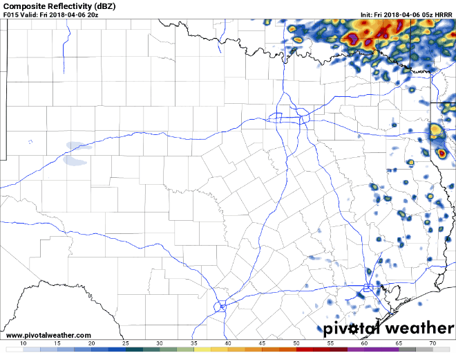
Simulated radar from one high-resolution model starting at 3 PM and running hourly until 6 PM today. This model depicts the highest storm coverage in Northeast Texas this afternoon, but expanding west along the cold front as it moves south toward the D/FW Metroplex. This is one possible solution, but I wouldn’t expect the radar to look exactly like this model shows.
Possible Alternative Scenarios and Discussion
There is some guidance suggesting a majority of the severe weather may be in Lousiana, with the far eastern sections of Northeast Texas and East Texas under the gun this afternoon and evening. This scenario would keep storm coverage more isolated into the eastern half of North Texas. Damaging winds and large hail would be likely with the strongest storms in the level 3 risk zone. Storms farther west (D/FW toward Tyler) in the level 2 zone would be more isolated/less intense with a threat of hail.
Another possibility we’ll be watching for is a stronger cap. Again – this would partially come into play in the first scenario above but could keep storm coverage lower with westward extent. The opposite scenario is that the cap is weaker and storms fire up earlier and farther west. That would result in a fairly potent line of storms impacting North Texas – including D/FW – by the late afternoon/early evening.
Honestly – we’ll just have to wait and see how the atmosphere behaves. Weather balloon data later this morning along with observations will dictate how today unfolds. If you’re in D/FW and points east in North Texas – I’d be ready for a strong storm today. We may have the most intense activity occur near the Texas/Lousiana state line from Texarkana south to Marshall into Lousiana (hence the level 3 risk for more widespread damaging winds).
If the cap is weaker farther west (toward I-35 and D/FW) or a bit more lift is available the threat for more numerous storms and an associated increase in the severe weather threat may occur. This is why it’s always a good idea to check back a few times a day for updated forecasts.
My plan is to have an updated blog post out by 1 PM with any changes that may occur. As always we’ll post updates on social media too. Twitter is the best platform to follow us on for rapid-fire updates as Facebook would put us in timeout for posting too much. We’re also on Instagram – a great place to see our storm chasing content.


0 Comments