
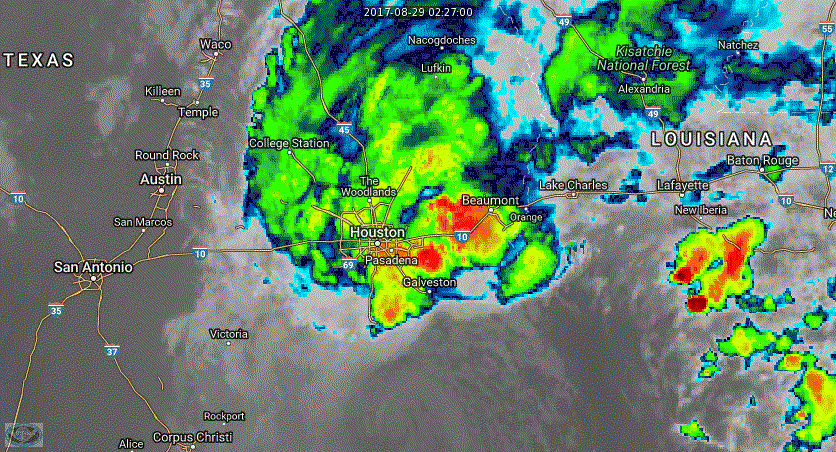
The cooler the cloud tops the taller the thunderstorm – and the more rain it may be producing. Like a radar the reds are worse.
An impressive convergence zone has set up on the Southeast Texas coast this evening. An easy way to explain it is to watch the radar look (above) and see how things just seem to get going right when they hit the coast. This is unfortunate since that means we’re seeing widespread moderate to locally heavy rains fall in areas that can’t handle another drop. The heaviest rains over the last few hours have been in Brazoria, Galveston, and Chambers counties. However, rainfall rates are higher with that convergence zone within 25 miles of the coast. Those are where we are seeing 1 to 2.5 inches of rain an hour. It only takes about a quarter to half an inch of rain per hour at this point to create new flash flooding in the most saturated zones. Plus any rain that falls has to make it was through the overflowing drainage systems. At the least, the ongoing rainfall across Southeast Texas will keep water levels steady and not allow them to decrease. More likely the additional rainfall will cause rises on local drainage systems – especially if we see over an inch per hour of rainfall in any given location. It should be noted we are starting to see an uptick in precipitation intensity east of Galveston up into the Intercoastal. If that ‘swings west’ into Houston over the next few hours there is the possibility that rain rates could jump upward significantly. Isolated tornadoes remain a threat into Tuesday with storms that can spin up in Southeast Texas – mainly in proximity to the coast. Some locations may receive widespread 2 to 4 inch rain totals tonight in Southeast Texas and the Upper Texas Coast. Localized rain totals approaching 10 inches are possible by sunrise Tuesday.
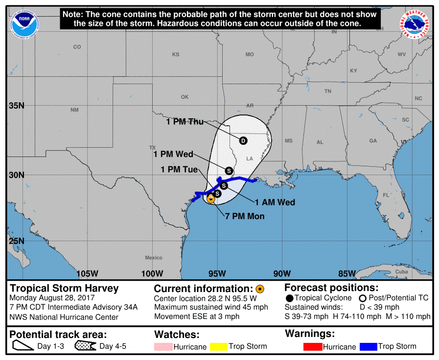
We’ve seen rainfall become more widespread today across Southeast Texas and the Upper Texas Coast. This precipitation increase is due to Harvey’s center of circulation moving back into the Gulf of Mexico. This evening it is located about 70 miles east of Port O’Connor or 145 miles southwest of Port Arthur. Slow movement to the east/southeast is expected before Harvey begins turning northeast on Tuesday – and by Tuesday Night beginning to accelerate (comparatively) to the northeast. The new National Hurricane Center forecast for Harvey brings good news to Southeast Texas. The track forecast has been nudged eastward in the coming days. Harvey will likely make landfall on the Bolivar Penesyla early Wednesday morning. After that, it’ll move northeast to near Beaumont by Wednesday afternoon – and by Thursday will be in northern Lousiana. The wettest side – or dirty side – of a tropical system is along and east of the track. Those to the west can still have some gusty winds and rain, but typically the rainfall is much lighter. The track farther away from Houston by Wednesday brings Houston into the ‘clean side’ of the system – and an expectation of lower rain chances and amounts. It’ll still probably be raining, but hopefully, it will be light. The historic flood situation doesn’t end when the rain stops in Southeast Texas. It will take days for streams to drain, a couple weeks for rivers to drain, and it will likely be near the end of the year before the Core of Engineers have all the lakes back inside ‘norms’. We’ve still got to deal with the prospect of another 5 to 10 inches of widespread rain across Southeast Texas and the Upper Texas Coast, but at least we’re starting to see the light at the end of the tunnel.
Here is the latest advisory from the National Hurricane Center on Harvey.
Tropical Storm Harvey Advisory Number 35
NWS National Hurricane Center Miami FL AL092017
1000 PM CDT Mon Aug 28 2017
…ADDITIONAL HEAVY RAINFALL OVERNIGHT IS EXPECTED TO WORSEN THE
FLOOD SITUATION IN SOUTHEASTERN TEXAS AND SOUTHWESTERN LOUISIANA…
…DO NOT ATTEMPT TO TRAVEL IN THE AFFECTED AREAS IF YOU ARE IN
A SAFE PLACE AND DO NOT DRIVE INTO FLOODED ROADWAYS…
SUMMARY OF 1000 PM CDT…0300 UTC…INFORMATION
———————————————–
LOCATION…28.2N 95.3W
ABOUT 70 MI…110 KM E OF PORT OCONNOR TEXAS
ABOUT 145 MI…235 KM SW OF PORT ARTHUR TEXAS
MAXIMUM SUSTAINED WINDS…45 MPH…75 KM/H
PRESENT MOVEMENT…ESE OR 120 DEGREES AT 3 MPH…6 KM/H
MINIMUM CENTRAL PRESSURE…997 MB…29.44 INCHES
WATCHES AND WARNINGS
——————–
CHANGES WITH THIS ADVISORY:
None
SUMMARY OF WATCHES AND WARNINGS IN EFFECT:
A Tropical Storm Warning is in effect for…
* Mesquite Bay to Intracoastal City
A Storm Surge Watch is in effect for…
* Port Bolivar to Morgan City
Catastrophic and life-threatening flooding continues in southeastern
Texas and portions of southwestern Louisiana. Please see warnings
and other products issued by your local National Weather Service
office for additional information on this life-threatening
situation.
A Tropical Storm Warning means that tropical storm conditions are
expected somewhere within the warning area within 36 hours.
A Storm Surge Watch means there is a possibility of life-
threatening inundation, from rising water moving inland from the
coastline, in the indicated locations during the next 48 hours.
For a depiction of areas at risk, please see the National Weather
Service Storm Surge Watch/Warning Graphic, available at
hurricanes.gov.
Interests elsewhere along the middle and upper Texas coast and in
southern Louisiana should continue to monitor the progress of
Harvey.
For storm information specific to your area, including possible
inland watches and warnings, please monitor products issued by your
local National Weather Service forecast office.
DISCUSSION AND 48-HOUR OUTLOOK
——————————
At 1000 PM CDT (0300 UTC), the center of Tropical Storm Harvey was
located near latitude 28.2 North, longitude 95.3 West. Harvey is
moving toward the east-southeast near 3 mph (6 km/h), and this
motion is expected to continue overnight. A turn toward the
northeast and a continued slow forward speed are expected Tuesday
and Tuesday night. On the forecast track, the center of Harvey is
expected to be just offshore of the middle and upper coasts of Texas
through Tuesday night, then move inland over the northwestern Gulf
coast on Wednesday.
Maximum sustained winds are near 45 mph (75 km/h) with higher gusts.
Little change in strength is forecast during the next 48 hours.
Tropical-storm-force winds extend outward up to 175 miles (280 km)
from the center. The National Ocean Service automated station at
the Matagorda Bay entrance recently reported sustained winds of 39
mph (63 km/h) and a wind gust of 47 mph (76 km/h).
The estimated minimum central pressure is 997 mb (29.44 inches).
HAZARDS AFFECTING LAND
———————-
RAINFALL: Harvey is expected to produce additional rainfall
accumulations of 10 to 20 inches through Thursday over parts of the
upper Texas coast into southwestern Louisiana. Isolated storm
totals may reach 50 inches over the upper Texas coast, including the
Houston/Galveston metropolitan area. These rains are currently
producing catastrophic and life-threatening flooding over large
portions of southeastern Texas and southwestern Louisiana. DO NOT
ATTEMPT TO TRAVEL IN THE AFFECTED AREA IF YOU ARE IN A SAFE PLACE.
DO NOT DRIVE INTO FLOODED ROADWAYS. Please see warnings and
products issued by your local National Weather Service office for
additional information on this life-threatening situation.
Elsewhere, Harvey is expected to produce total rain accumulations of
5 to 15 inches farther east across south-central Louisiana.
Rainfall amounts of 5 to 10 inches are expected in southeast
Louisiana and coastal Mississippi and Alabama.
A list of rainfall observations compiled by the NOAA Weather
Prediction Center can be found at:
www.wpc.ncep.noaa.gov/discussions/nfdscc1.html
STORM SURGE: The combination of a dangerous storm surge and the
tide will cause normally dry areas near the coast to be flooded by
rising waters moving inland from the shoreline. The water is
expected to reach the following heights above ground if the peak
surge occurs at the time of high tide…
Port Aransas to Morgan City including Galveston Bay…1 to 3 ft
The deepest water will occur along the immediate coast near the
area of onshore winds. Surge-related flooding depends on the
relative timing of the surge and the tidal cycle, and can vary
greatly over short distances. For information specific to your
area, please see products issued by your local National Weather
Service forecast office.
WIND: Tropical storm conditions are occurring in rain bands well
to the east of the center of Harvey, and along the coast to the
southwest and west of the center. Tropical storm conditions are
likely to persist within the warning area during the next couple
of days.
SURF: Swells generated by Harvey are affecting the coasts of Texas
and Louisiana. These swells are likely to cause life-threatening
surf and rip current conditions. Please consult products from your
local weather office.
TORNADOES: A few tornadoes are possible through Tuesday across
southern Louisiana and extreme southeast Texas.


0 Comments