
This blog will cover the upcoming weather concerns for Sunday and Monday. For today’s severe weather and flooding threats please head over to Jenny’s blog written earlier this morning.
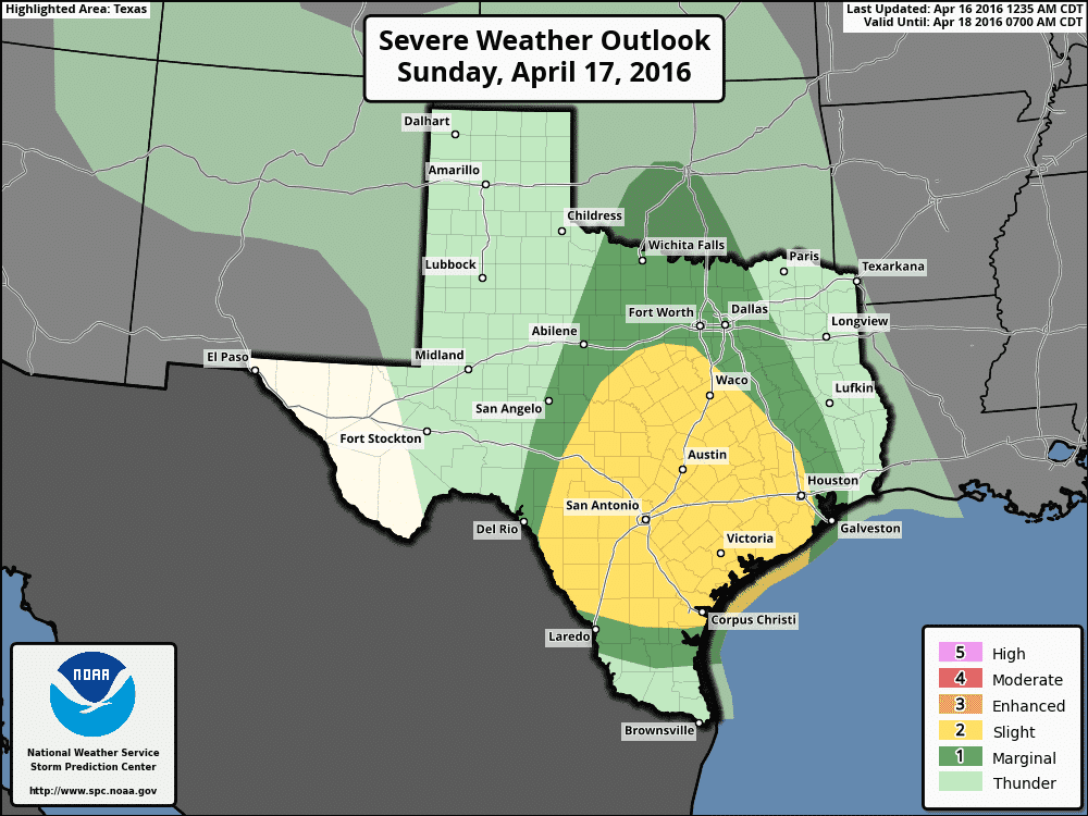
The Storm Prediction Center has issued their standard category 2 risk of severe weather for South-Central Texas, the Coastal Plains, Brazos Valley, Central Texas, the Hill Country, and southern North Texas on Sunday. A category 1 marginal risk includes all of North Texas up into Texoma. The atmosphere will be markedly different compared to the severe weather events over the past month. The setup will be more tropical in nature due to very high moisture levels int he atmosphere. That’s why we’ll be dealing with widespread heavy rain and flooding over the next few days. Instead of a hail-driven severe weather threat we’ll be watching for a damaging wind/tornado threat. The threat for hail – while not zero – will be lower. The highest severe weather threat will be during the late afternoon and early evening hours when the atmosphere is most unstable. Even with widespread cloud cover and temperatures only in the lower 70s the atmosphere will still be unstable. Wind shear values will be supportive of rotating thunderstorms. The threat for a couple tornadoes and localized damaging wind gusts over 60 MPH will exist. Depending on what happens tonight we should be able to narrow down a ‘threat zone’ by tomorrow morning. A tornado outbreak isn’t on the cards at this time but if a tornado comes down your street that won’t really matter. Have a way to receive weather warnings and check back for forecast updates.

Possible rain totals through Tuesday evening. Don’t get hung up on the area of heaviest rains since those will be determined by factors we can’t forecast in advance
Possible rain totals through Tuesday evening. Don’t get hung up on the area of heaviest rains since those will be determined by factors we can’t forecast in advance
A significant heavy rain event is once again on our doorstep. The threat for flash flooding will be highest from Sunday through Tuesday. River flooding and lake rises will continue for the next week – if not into the end of April. Widespread rain accumulations of 2 to 5 inches are expected across the eastern two-thirds of Texas over the next couple of days. Some of that rain may fall in a period of several hours while others may see it fall in a multi-day timeframe. Isolated rainfall totals of 8 to 10 inches are not out of the question where we see thunderstorms stall out or ‘train’ over the same areas. Flash Flood Watches are already in effect for portions of Texas and I do anticipate additional watches will be issued this afternoon for most major cities along and east of Interstate 35. We should be through most of the heaviest rain by Tuesday evening unless the upper level storm system slows down.


0 Comments