
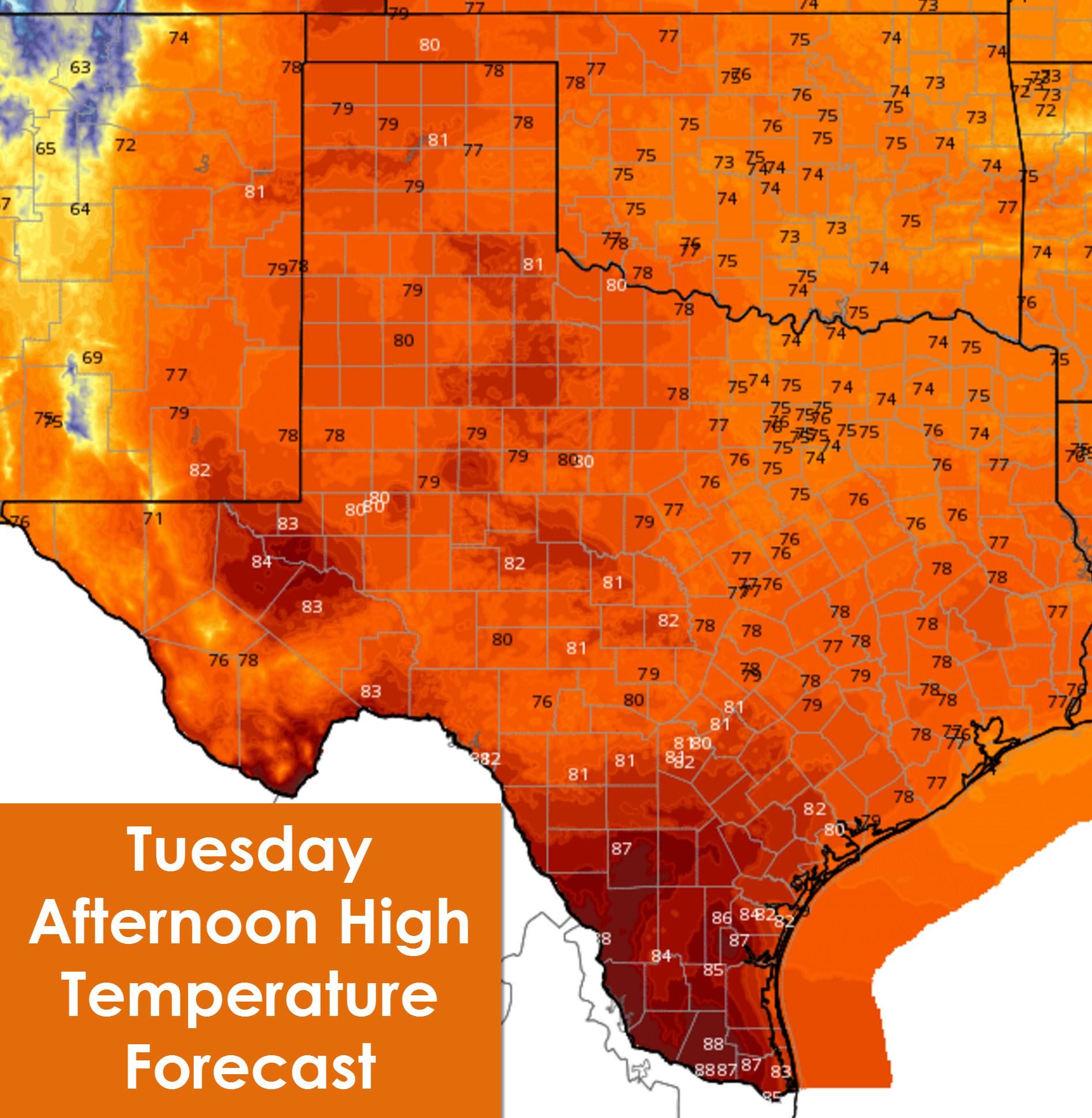
A little late but better than never. I figured this would be the morning to catch up on sleep before we get back into an active pattern. I just didn’t expect my alarm to not go off in the first place. Go figure huh? Anyway we’re starting off with the dreaded fog once again across the eastern third of Texas. Just like on Monday we’ll see it burn off by late morning. In its wake we’ll enjoy another mostly sunny day with seasonably pleasant temperatures. This afternoon’s high temperatures will top out in the 70s to right around 80 degrees across the Texas Panhandle, South Plains, Northwest Texas, Big Country, Concho Valley, Hill Country, Central Texas, North Texas, Texoma, Northeast Texas, East Texas, Southeast Texas, and the Brazos Valley. Deep South Texas and the Rio Grande Valley are going to be hot today with temperatures soaring into the upper 80s. Parts of the Permian Basin will also be on the toasty side with mid 80s.
Tonight’s low temperatures will be noticeably warmer across the Rio Grande Valley and Deep South Texas as an influx of moisture streams inland from the Gulf of Mexico. Brownsville and McAllen should both drop to around 70 degrees. Corpus Christi will drop to around 67 to 68 degrees. The Coastal Plains and Southeast Texas will also be a few degrees warmer with low 60s anticipated tonight. The Hill Country, Central Texas, North Texas, and Northeast Texas should see comfortable temperatures with upper 50s to low 60s. The Concho Valley, Big Country, Northwest Texas, and Permian Basin will also drop off into the 50s overnight. Finally our typically coolest locations in Texas across the Panhandle, South Plains, and Far West Texas will see near average low temperatures in the 40s. Fog may become an issue again by Wednesday morning across Southeast Texas and other parts of Texas. However at this time we’re not forecasting the fog to become nearly as widespread as we’ve seen on Monday and again this morning.

Our next storm system will result in increasing rain chances by Wednesday Night across most of Texas. This system will feature less rain than the past two events across Texas. Localized flash flooding may become an issue in Central Texas into parts of North Texas on Thursday. At this time the threat for widespread/significant flash flooding seems unlikely. A severe weather threat may develop on Wednesday Night across the Permian Basin and South Plains in the form of hail and localized damaging winds. On Thursday the threat for a few severe storms looks to spread east towards Interstate 35. We’ll have another blog later this morning detailing all the threats and timing for our late week system.


0 Comments