Good morning and welcome to what has become a very busy weather week for Texas. Like yesterday morning I’m going to break the blog down into points for easy reading. We continue to anticipate a widespread heavy rain event for the state of Texas over the coming days.
This Morning
Showers and a few thunderstorms are moving east across the Texas Panhandle and South Plains just after 6 AM. This activity is not severe but is producing locally heavy rain for the morning drive. Observational data from the West Texas Mesonet shows that half an inch up to two inches of rain has fallen across the southwest Texas Panhandle northeast into Amarillo. We’ll only add to these totals as more rain continues.
Day by day Rain Chances
Today and Tonight
Besides the widespread rain across the Panhandle and South Plains this morning we’re expecting more activity later today. Scattered showers and thunderstorms are possible across Far West Texas, the Permian Basin, the Big Country, Concho Valley, Southwest Texas, South-Central Texas including Austin and San Antonio, south into Deep South Texas including Corpus Christi into the Rio Grande Valley. Rain chances go up to 100 percent tonight across the Texas Panhandle, South Plains, Rolling Plains, all of West Texas, and the Permian Basin. Scattered storms will continue across the Big Country, Concho Valley, Southwest Texas, and South Texas.
Thursday and Thursday Night
Numerous showers and thunderstorms, some containing heavy rain, will continue across the Texas Panhandle, South Plains, Rolling Plains, Permian Basin, Concho Valley, Big Country, Southwest Texas, South-Central Texas. Scattered showers/storms are forecast in North Texas, Central Texas, Southeast Texas, and the Rio Grande Valley. By Thursday Night rain chances will increase across Northeast Texas. Widespread rain, including the potential for heavy rain, is expected Thursday Night across Northwest Texas, the Big Country, Concho Valley, North Texas, Central Texas, South-Central Texas.
Friday and Friday Night
Numerous showers and thunderstorms are forecast across North Texas, Central Texas, Northeast Texas, and East Texas. Scattered activity is forecast across Southeast Texas, Deep South Texas, the Rio Grande Valley, the Concho Valley, and Big Country. Far West Texas, the Texas Panhandle, South Plains, Rolling Plains will start drying out on Friday. On Friday Night we may actually see rain chances spread back west into Northwest Texas and the Permian Basin in addition to the likely/numerous showers/storms across the Interstate 35 corridor from the Red River south to Mexico. Many outdoor events are going to be in danger of being rained out in D/FW south through Waco, Austin, San Antonio plus the numerous towns in between.
Saturday and Saturday Night
Yesterday I was hopeful that we might see rain start to taper off along and west of Interstate 35 on Saturday. Since then weather model guidance has shown the storm system responsible for all this mess sticking around longer so I’m afraid a very wet Saturday is in store for outdoor events across North Texas, Central Texas, South Texas, the Rio Grande Valley, Northeast Texas, East Texas, and Southeast Texas. Scattered rain/storm chances will continue across Northwest Texas, the Big Country, and the Concho Valley. The Texas Panhandle, South Plains, Permian Basin, and Far West Texas have a better chance than not at being dry on Saturday. We start to see some eastward progression of rain chances by Saturday Night with the best chances along and east of Interstate 35 covering North Texas, Central Texas, South-Central Texas, Northeast Texas, East Texas, Southeast Texas, and the coastal plains. I do want to put some caution on this timeframe as there is weather model variability. Depending on the eventual solution there is the possibility rain chances will need to be increase Saturday Night into Sunday.
Rain Totals and Flooding Potential
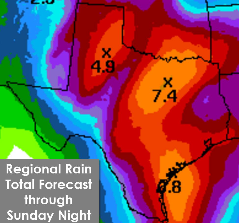
I continue to expect that mostly everyone in Texas will see rain by time this event concludes on Sunday. Not everyone will see the same rain totals. Some are going to see a quarter of an inch (mainly in the Big Bend) while others could receive enough to cause problematic flooding. The rain total forecast I’m sharing here is a general expectation on a regional basis. Some will receive less and others could receive more than what is shown. The official rain forecast for this event from the Weather Prediction Center has once again increased. A corridor of enhanced rainfall is possible across North Texas – but exactly where is still very much uncertain. Weather models are in agreement that an enhanced and significant area of rain will fall somewhere but can’t pin it down exactly. That means a tight gradient with one person getting 3 inches of rain while another individual about 25 miles east could get over 10 inches. This enhanced band of rain looks to set up shop somewhere over North Texas. Obviously if it sets up shop over the D/FW Metroplex we would be looking at significant issues and drastic variations in rain totals from one town to another. In short you can expect the total rainfall forecast to change as confidence increases in a particular solution. The good news is we should see widespread rain totals of 1 to 5 inches across nearly all of Texas through Sunday with this event. Localized rain accumulations of 6 to 10 inches are possible in North and Central Texas. Flash Flood Watches are in effect across the Texas Panhandle, West Texas, and Permian Basin. Additional flash flood watches will likely be issued later today for more locations in Texas.
Severe Weather Potential
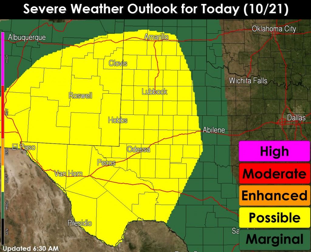
A few severe thunderstorms are possible today across the southern Texas Panhandle, South Plains, Permian Basin, western portions of the Concho Valley and Big Country, and Far West Texas. Wind shear will be supportive of organized thunderstorms. Widespread clouds will help keep the atmosphere only marginally unstable thus preventing a more significant severe weather event. The strongest storms today will likely take on supercellular characteristics. Large hail up to the size of golfballs and locally damaging wind gusts are possible with the strongest storms. The tornado threat will be low today but not zero. We’ll have to watch for any storms that interact with outflow boundaries or other mesoscale factors.
Summary
The next few days continue to look very wet for the State of Texas. We’ll have to deal with bouts of stronger storms along with heavy rain. Very dry weather over the past few months means most of the state can handle several inches of rain. However by Thursday Night into Friday we could start dealing with flooding issues across parts of North Texas and other locations. As we get into the range of high-resolution weather model guidance we should be able to pin down more specific rain total forecasts and adjust flooding potential from there. Those of you asking where the rain and El Nino has gone can rest easy – it’s back with a vengeance.


0 Comments