
An incredibly complex forecast is in store for Texas over the coming three days. In the five years we’ve run a weather blog at Texas Storm Chasers the next few days are probably some of the most complex in terms of a forecast. It only becomes more complex because Hurricane Patricia – now the strongest hurricane on record in the eastern Pacific (or Atlantic). We have a lot to talk about and with the potential for significant impacts I’ll try to do my best at explaining it all.

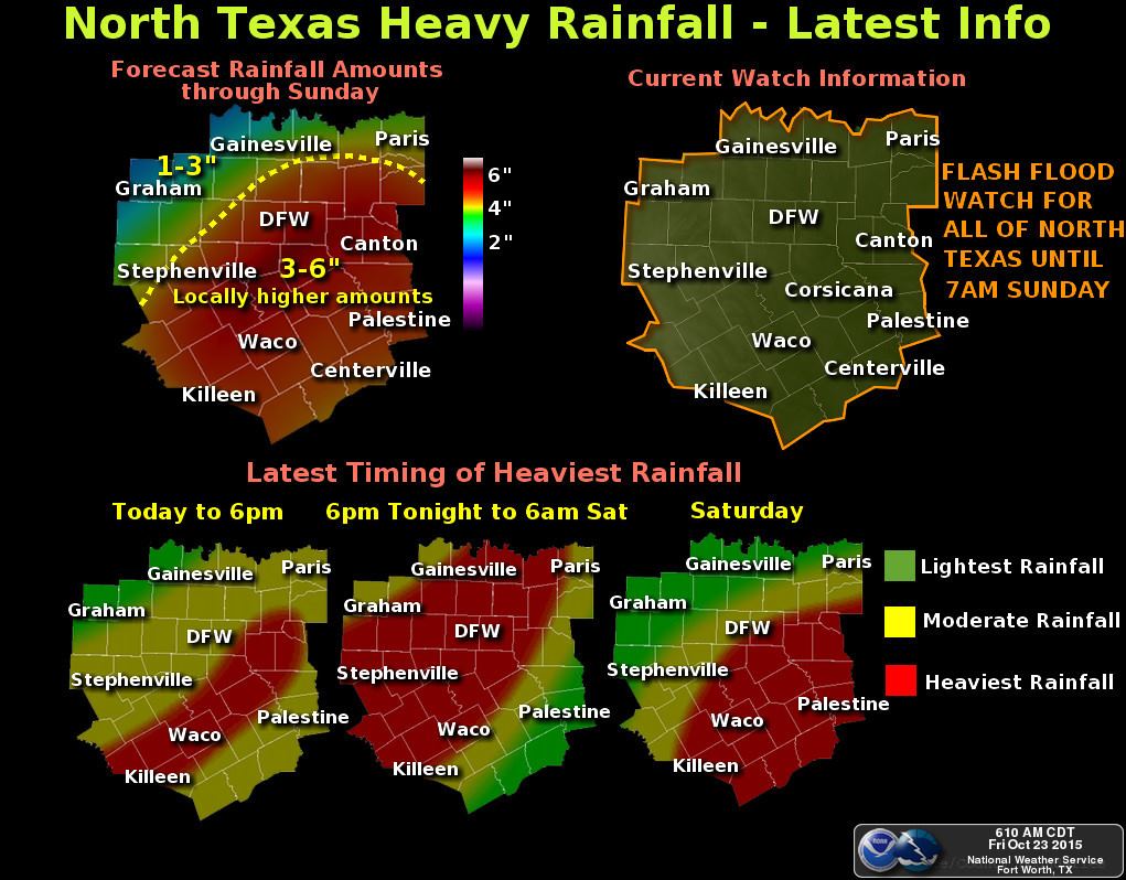
Since late yesterday afternoon and overnight we’ve seen widespread rain and thunderstorms over the Big Country, Northwest Texas, and North Texas. Overnight the heaviest rain has fallen in a corridor from Hamilton northeast through the D/FW Metroplex to Sherman, Bonham, and Paris. Relatively widespread rain accumulations of 1 to 3 inches have been recorded with isolated totals up to 5 inches. The rain last night and this morning was the first of several rounds were expecting. We’re no where near done and frankly this event is just beginning. I would prefer there not be dozens of messages in my inbox saying the forecast was a bust until Sunday (at the earliest).
Let me preface the forecast discussion with a couple of notes. We cannot accurately tell you where 10-12+ inch rain totals will fall. Where we do see those extremely heavy rain totals is where we’re going to be most concerned about the threat of widespread/potentially significant flash flooding. Most folks will fall into the bracket of 3 to 7 inches of additional rain on top of what we’ve already seen fall overnight. I know most of you have seen little to no rain (I’m talking to you in Central Texas, South Texas, and Southeast Texas). It also won’t be raining all the time over the coming days. We’ll see activity come in waves with breaks in between.
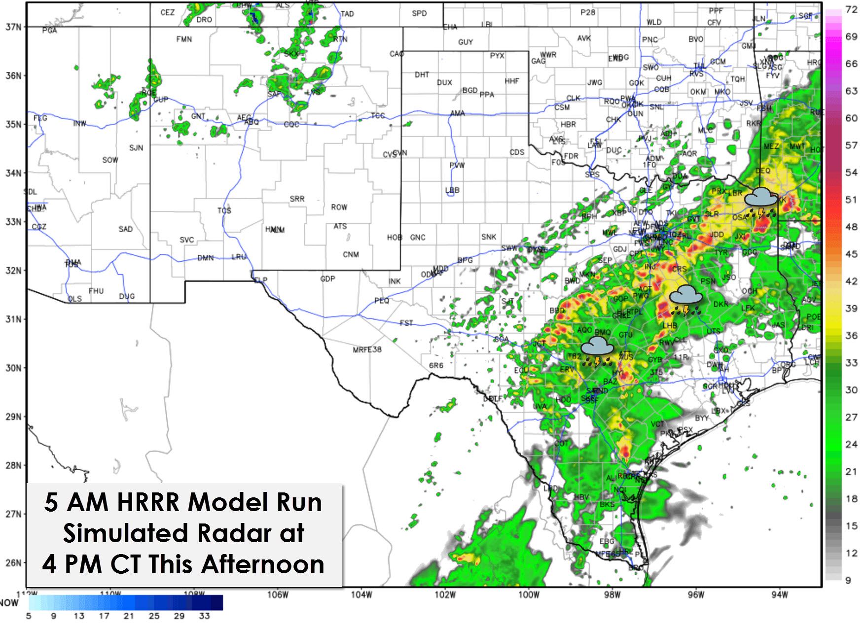
For the short-term forecast through the early afternoon we’re using the High Resolution Rapid Refresh (HRRR) weather model. It did fairly well overnight with the placement of rain and thus we’ll continue to use it for this afternoon. A marked increase in precipitation coverage and intensity is anticipated by lunchtime across South-Central Texas, Central Texas, and Northeast Texas including the Austin and San Antonio areas. By mid to late afternoon thunderstorms should be ongoing across Central Texas, the Hill Country, North Texas, and potentially Northeast Texas. Showers and storms are also possible across East Texas and the Brazos Valley. The heaviest storms will be capable of producing rainfall rates of 2 inches per hour. A few storms may also become strong with the possibility of hail up to the size of quarters, 55 MPH wind gusts, and a very low tornado threat.

The threat for heavy rain increases tonight across North Texas, Central Texas, the Hill Country, and parts of South Texas. The flooding threat looks to increase as some locations may pick up 3 to 7 inches of rain tonight. I can’t tell you with any accuracy where the localized heavy bands of rain will set up since those are dictated by mesoscale processes which can’t be forecast more than a few hours in advance.
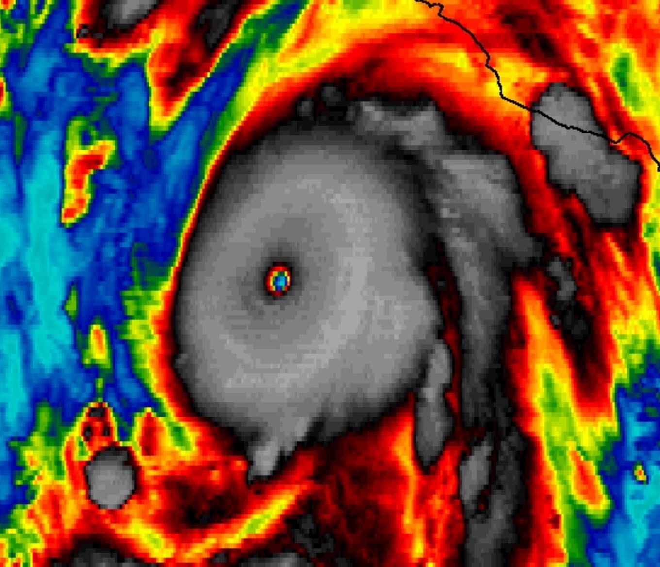

The forecast from Saturday onward has changed due to the latest forecast for Hurricane Patricia. Now the strongest hurricane on record for either the eastern Pacific or Atlantic basins this storm has created a forecast mess. Patricia will make landfall this afternoon near Puerto Vallarta, Mexico as a devastating category 5 hurricane. Maximum sustained winds are at 200 MPH with gusts closer to 250 MPH. Those winds are comparable to what you would see with an EF5 tornado. There will be utter destruction where the eyewall makes landfall and the surge is going to be incredible. Even with all that Patricia will not be a hurricane when it reaches Texas. The circulation will rapidly weaken and possibly even dissipate.

On Saturday an area of low pressure, possibly the remnants of Patricia, will move into the Rio Grande Valley from Mexico. Moisture from Patricia along with southeast winds across the western Gulf of Mexico, the Rio Grande Valley, South Texas, and Southeast Texas will create an incredibly moist environment. Precipitable water values, a way to measure how much water/moisture is in the atmosphere, will be 500 to 600 percent above norman. The stage will be set for prolific rainfall rates. This has required a forecast adjustment compared to two days ago when the heaviest rains were forecast to be across North and Central Texas. Its not that the heaviest rains have moved south because this is a completely different system from what is causing rains across North Texas today. By Saturday evening most weather models have a non-tropical area of low pressure moving northeast up the Texas coastline from the Rio Grande Valley into Southeast Texas. This low pressure is expected to continue its northeast move on Sunday and be near Lake Charles near dinner time on Sunday.
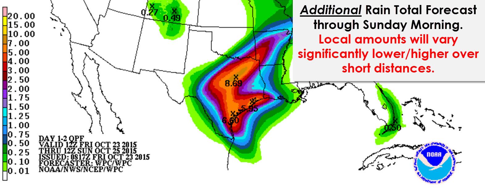
Due to the amount of moisture available to the low along with expect dynamics a significant and widespread rain event is forecast for the Rio Grande Valley into Southeast Texas. Widespread 2 to 5 inch rain amounts are probable with located accumulations up to 12 inches. Much of that rain could fall in a matter of 6 to 12 hours. The eventual location of the heaviest rain along with rain totals will be determined on where the low passes. We’ll have to closely monitor the track because if it moves over the warm waters of the Gulf instead of just inland it could try and become a tropical cyclone versus a non-tropical low. In terms of the rain forecast it doesn’t really matter as much if its a tropical or nontropical low. The ridiculous amount of moisture will still be present.
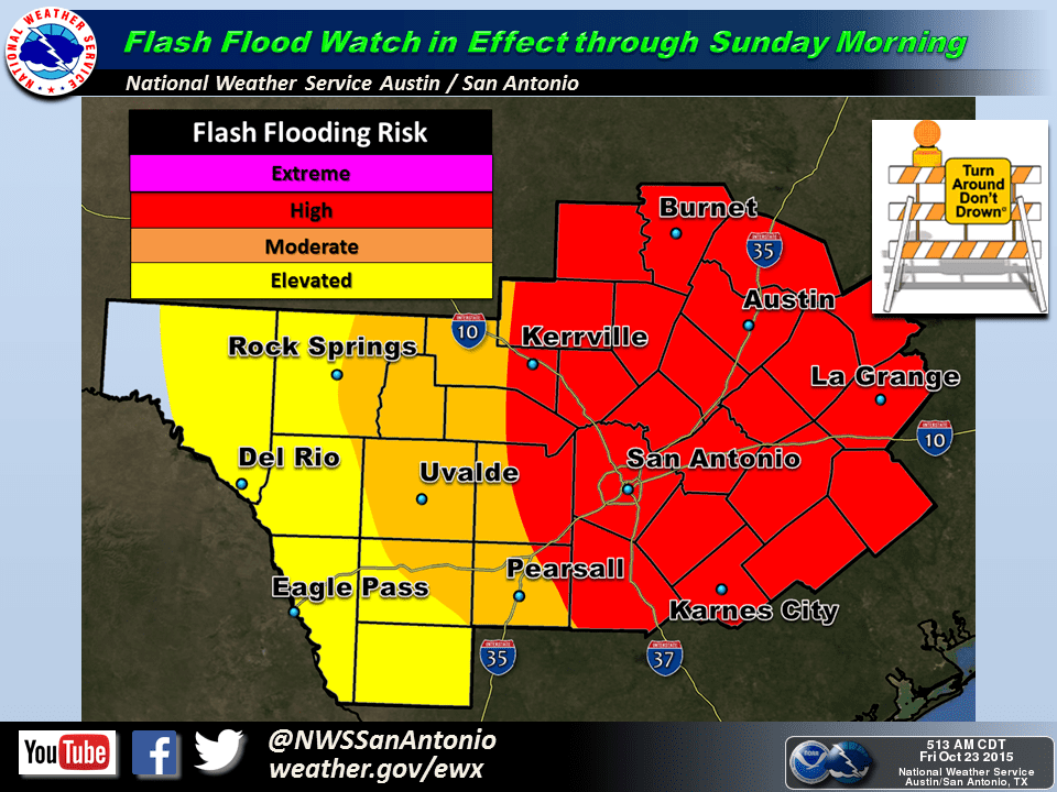
Another forecast adjustment thanks to Patricia is the introduction of a severe weather risk. Locations to the east and northeast of the low will be in an area of enhanced wind shear. Low-level instablity values are expected to be at least marginally favorable for rotating/low-topped thunderstorms. The amount of available instablity will determine the significance of the severe weather threat. At this time we are concerned about a tornado risk in the Rio Grande Valley and South-Central Texas on Saturday with the tornado risk spreading into Southeast Texas Saturday Night and Sunday.
As you can see we’ve got a lot to deal with over the next few days. Two storm systems both with an almost endless supply of rich moisture. Some locations will likely receive 10-12+ inches of rain but those totals will be isolated. Most folks will receive 2 to 6 inches of rain. Obviously the flood risk will be highest where the most rain falls – but we also need to watch for how much rain falls in a short period of time. If you get 2 inches of rain in 30 minutes that’ll cause big problems just like 8 inches in 3 hours. Cities and urban areas will be particularly susceptible to flash flooding. We’ll be doing a periscope video chat at 10 AM CT to talk about the setup and answer a few of your questions. You don’t need a twitter/periscope account to watch. The link will be posted on our social media platforms and twitter feed (which you can access on the right sidebar on our desktop side or just below this post on your mobile devices).


0 Comments