

At 4 AM CDT Tropical Storm Bill was located 55 miles southeast of Port O’Connor, Texas. The storm is moving northwest at 13 MPH. Simple math indicates we should have landfall between 7 AM and 10 AM this morning. Minor tidal surge has been noted along the coast which may cause minor coastal flooding. Gusty winds will be possible on the northeast side of the system as it makes landfall and moves inland through early afternoon. The tropical storm wind threat and the coastal flooding threat are expected to remain on the limited side of the impact spectrum. What is going to be the focus today and on Wednesday will be the likelihood of flooding rains along and east of the center’s path. The storm will continue northwest into Central Texas this evening before turning north and moving over North Texas on late tonight and on Wednesday before exiting into Oklahoma by Wednesday evening. Isolated tornadoes will be possible in East Texas today due to the enhanced low level wind fields from Bill.
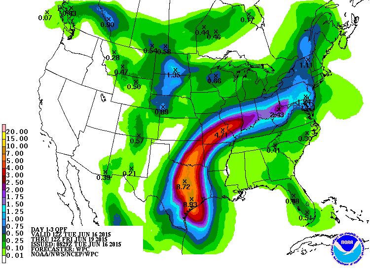
Projected rain totals through Friday morning from the Weather Prediction Center/NOAA
The latest rain total forecast through Friday Morning depicts a dangerous situation for parts of Southeast Texas, Central Texas, and North Texas. Compared to yesterday we have seen a ~50 mile shift west in the projected track of Bill. The result is that the heaviest rains are now forecast to fall literally on Interstate 35 from Austin north into Oklahoma including the D/FW Metroplex. Widespread rain totals of 4 to 8 inches are likely with isolated totals up to 1 foot in some locations. That kind of rain in only a day or two will result in the threat for dangerous and widespread flash flooding. Rapid rises on local streams and creeks will be probable in the hardest hit areas. Rivers will quickly rise back into flood stage and some local lakes will once again be dealing with ridiculously high to record high levels. The lake and river flooding will persist well into next week even after the rains have stopped. As always I want to stress that not everyone will see the very heavy rains, not everyone will see flooding, not everyone will see the significant flooding. However I do believe we will have some locations hard hit by this system. Bill will be remembered for the flooding it produces – no question about it. Don’t be afraid about it or get yourself into a panic. Stay up to date with your local weather conditions and if a flash flood warning is issued move to higher ground if needed. Listen to local emergency management announcements and follow their directions.
We’ll be here keeping you updated on the track of the storm along with short-term forecast updates once we start really having to deal with the flooding potential later today, tonight, and on Wednesday. I’ll leave you with the full public advisory for Tropical Storm Bill as of 4 AM CDT.
TROPICAL STORM BILL ADVISORY NUMBER   2
NWS NATIONAL HURRICANE CENTER MIAMI FL       AL022015
400 AM CDT TUE JUN 16 2015

...TROPICAL STORM BILL APPROACHING THE TEXAS COAST...
...EXPECTED TO BRING HEAVY RAINS TO PORTIONS OF TEXAS...


SUMMARY OF 400 AM CDT...0900 UTC...INFORMATION
----------------------------------------------
LOCATION...27.9N 95.7W
ABOUT 55 MI...90 KM SE OF PORT OCONNOR TEXAS
ABOUT 110 MI...180 KM SSW OF GALVESTON TEXAS
MAXIMUM SUSTAINED WINDS...50 MPH...85 KM/H
PRESENT MOVEMENT...NW OR 310 DEGREES AT 13 MPH...20 KM/H
MINIMUM CENTRAL PRESSURE...1004 MB...29.65 INCHES


WATCHES AND WARNINGS
--------------------
CHANGES WITH THIS ADVISORY:

None.

SUMMARY OF WATCHES AND WARNINGS IN EFFECT:

A Tropical Storm Warning is in effect for...
* Baffin Bay to High Island Texas

A Tropical Storm Warning means that tropical storm conditions are
expected somewhere within the warning area.

For storm information specific to your area, including possible
inland watches and warnings, please monitor products issued by your
local National Weather Service forecast office.


DISCUSSION AND 48-HOUR OUTLOOK
------------------------------
At 400 AM CDT (0900 UTC), the center of Tropical Storm Bill was
located near latitude 27.9 North, longitude 95.7 West. Bill is
moving toward the northwest near 13 mph (20 km/h) and this general
motion is expected to continue today.  On the forecast track, the
center of Bill is expected to make landfall in the warning area
along the Texas coast later this morning and move inland over
south-central Texas this afternoon and tonight.

Maximum sustained winds remain near 50 mph (85 km/h) with higher
gusts.  Little change in strength is likely before landfall.
Weakening is forecast after the center moves inland later today, and
Bill is expected to weaken to a tropical depression tonight.

Tropical storm force winds extend outward up to 150 miles (240 km)
from the center.

The estimated minimum central pressure is 1004 mb (29.65 inches).


HAZARDS AFFECTING LAND
----------------------
RAINFALL:  Bill is expected to produce total rain accumulations of 4
to 8 inches over eastern Texas and eastern Oklahoma and 2 to 4
inches over western Arkansas and southern Missouri, with possible
isolated maximum amounts of 12 inches in eastern Texas.

WIND:  Tropical storm conditions are expected to reach the coast
within the warning area in a few hours.

STORM SURGE:  The combination of a storm surge and the tide will
cause normally dry areas near the coast to be flooded by rising
waters.  The water could reach the following heights above ground if
the peak surge occurs at the time of high tide...

Upper Texas coast...2 to 4 feet
Western Louisiana coast...1 to 2 feet

The deepest water will occur along the immediate coast near and to
the right of the landfall location.  Surge-related flooding depends
on the relative timing of the surge and the tidal cycle, and can
vary greatly over short distances.  For information specific to your
area, please see products issued by your local National Weather
Service forecast office.

TORNADOES:  A few tornadoes will be possible across portions of
eastern Texas and far western Louisiana today and tonight.


0 Comments