

A level 2 possible severe weather risk has been issued for the Texas Panhandle, South Plains, Permian Basin, Northwest Texas, West-Central Texas, the Concho Valley, the Big Country, and western North Texas. A level 1 marginal risk includes South-Central Texas, Central Texas, and the eastern half of North Texas. With a strong upper level jet stream in place along with moderate low level wind shear we’ll have to watch for a few rotating thunderstorms today. The atmosphere is more tropical in nature versus one we typically see in mid-May. The tropical nature of the atmosphere will reduce the threat for larger hail but will promote the potential for very heavy rain. Localized damaging wind gusts and brief tornadoes are also possible. We may end up having several brief tornadoes today in the level 2 zone but that potential will be determined on how much low level heating we get today. We’ve already had strong storms in West Texas this morning and the threat will continue much of today.
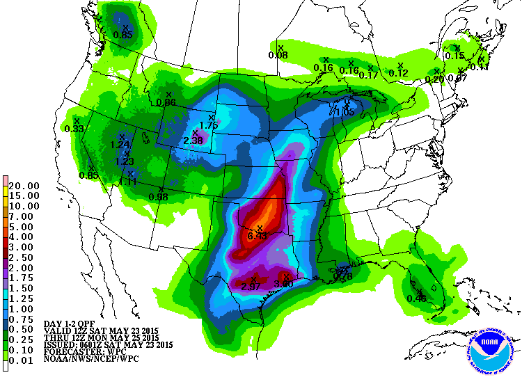
Forecast rain accumulation through Monday morning
As we’ve been saying for days the potential for significant flooding is by far the biggest concern as we head into tonight into Sunday. While severe weather will be possible flooding will likely become the big story by tomorrow. Stay safe and don’t go driving into water on roads. The most likely area for high-impact flooding is along the Red River in Northwest Texas southeast to north of the D/FW Metroplex. While flash flooding will be the biggest concern through Monday – we’ll have to deal with major river and lake flooding for the next week at least.


0 Comments