
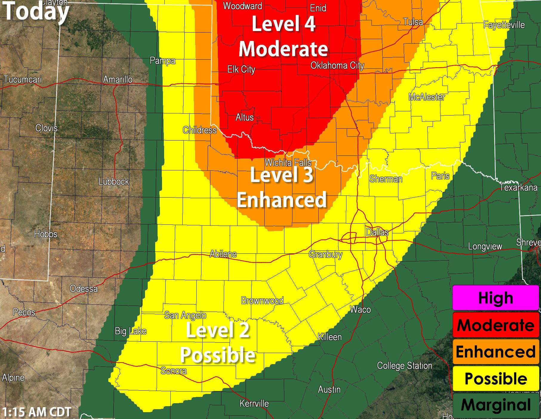
A dangerous severe weather day is setting up for Kansas, Oklahoma, and portions of Texas as ingredients come together to support a possible severe weather outbreak. At this time it appears the most significant and widespread severe weather will remain just north of the Red River – where a tornado outbreak is possible across Oklahoma. An enhanced severe weather risk includes the eastern Texas Panhandle and Northwest Texas. A possible severe weather risk includes North Texas, the Big Country, the Concho Valley, and the Hill Country. The strongest storms will be capable of producing baseball size hail, damaging straight line winds over 70 MPH, and tornadoes. There is the potential for an enhanced tornado threat in Northwest Texas and perhaps western North Texas.
Unlike last Saturday where the severe weather setup became less serious due to morning storms – today is actually becoming more serious because it looks like we’ll clear out the morning storms across the moderate/enhanced risk zones by late morning. The result will be a rapid destabilization of the atmosphere in the presence of a very strong upper level storm system. The situation for western and central Oklahoma looks quite concerning with several tornadoes, including long-track tornadoes, a distinct possibility. We’ll have to see how things look later this morning to see if we need to extend the higher tornado potential further south into Texas. Regardless this is a day to check back for updates, especially if you’re in Northwest Texas or western North Texas.
DAY 1 CONVECTIVE OUTLOOK
NWS STORM PREDICTION CENTER NORMAN OK
1259 AM CDT SAT MAY 16 2015
VALID 161200Z – 171200Z
…THERE IS A MDT RISK OF SVR TSTMS ACROSS PARTS OF SOUTHERN
NEBRASKA..WESTERN AND CENTRAL KANSAS…THE WESTERN HALF OF
OKLAHOMA…AND A SMALL PORTION OF WESTERN NORTH TEXAS…
..THERE IS AN ENH RISK OF SVR TSTMS FROM CENTRAL NEB SWD TO N TX
…THERE IS A SLGT RISK OF SVR TSTMS FROM THE NRN PLAINS SWD TO
CENTRAL TX…
…THERE IS A MRGL RISK OF SVR TSTMS ACROSS THE PLAINS FROM THE
U.S./CANADA BORDER TO THE RIO GRANDE…
…THERE IS A MRGL RISK OF SVR TSTMS ACROSS SRN NY AND ROUGHLY THE
NRN HALF OF PA INTO NRN NJ…
..SUMMARY
AN OUTBREAK OF SEVERE THUNDERSTORMS IS EXPECTED ACROSS THE PLAINS
STATES SATURDAY INTO SATURDAY NIGHT…FROM PARTS OF NEBRASKA
SOUTHWARD TO TEXAS. RISKS WILL INCLUDE VERY LARGE HAIL…DAMAGING
WIND GUSTS…AND SEVERAL TORNADOES — WITH A FEW LIKELY TO BE
SIGNIFICANT/LONG-LIVED.


0 Comments