
The Storm Prediction Center has issued a Tornado Watch until 10 PM for the southern Texas Panhandle, South Plains, West-Central Texas, and Northwest Texas. Supercell thunderstorms should develop after 4 PM just south/southeast of Amarillo and possibly further south and west. These storms will likely be severe with very destructive hail, damaging wind gusts, and a tornado threat. Storms will actually intensify as they move closer to Northwest Texas/West-Central Texas where more moisture is in place. The severe weather threat will continue after dark as storms move southeast into Northwest Texas, possibly forming into a bow echo with an enhanced wind threat. These storms are expected to move into North Texas late this evening with a threat of large hail, destructive winds, and possibly a tornado.
THE NWS STORM PREDICTION CENTER HAS ISSUED A
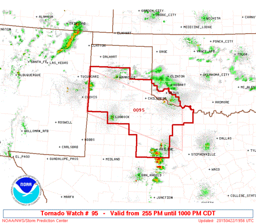
* TORNADO WATCH FOR PORTIONS OF
SOUTHWEST OKLAHOMA
WEST AND WESTERN NORTH TEXAS
* EFFECTIVE THIS WEDNESDAY AFTERNOON AND EVENING FROM 255 PM
UNTIL 1000 PM CDT.
* PRIMARY THREATS INCLUDE…
A FEW TORNADOES POSSIBLE
WIDESPREAD LARGE HAIL AND ISOLATED VERY LARGE HAIL EVENTS TO 3
INCHES IN DIAMETER LIKELY
SCATTERED DAMAGING WIND GUSTS TO 70 MPH LIKELY
SUMMARY…SCATTERED THUNDERSTORMS ARE BEGINNING TO DEVELOP WEST OF
AMARILLO. THESE STORMS WILL TRACK EAST-SOUTHEASTWARD THROUGH THE
AFTERNOON AND EVENING INTO AN AREA OF INCREASINGLY MOIST/UNSTABLE
AIR. SUPERCELLS CAPABLE OF VERY LARGE HAIL…DAMAGING WINDS…AND A
FEW TORNADOES ARE EXPECTED.
THE TORNADO WATCH AREA IS APPROXIMATELY ALONG AND 60 STATUTE
MILES NORTH AND SOUTH OF A LINE FROM 85 MILES WEST NORTHWEST OF
PLAINVIEW TEXAS TO 50 MILES SOUTH OF WICHITA FALLS TEXAS. FOR A
COMPLETE DEPICTION OF THE WATCH SEE THE ASSOCIATED WATCH OUTLINE
UPDATE (WOUS64 KWNS WOU5).
PRECAUTIONARY/PREPAREDNESS ACTIONS…
REMEMBER…A TORNADO WATCH MEANS CONDITIONS ARE FAVORABLE FOR
TORNADOES AND SEVERE THUNDERSTORMS IN AND CLOSE TO THE WATCH
AREA. PERSONS IN THESE AREAS SHOULD BE ON THE LOOKOUT FOR
THREATENING WEATHER CONDITIONS AND LISTEN FOR LATER STATEMENTS
AND POSSIBLE WARNINGS.


0 Comments