
For the most recent update on the impending winter weather >>>> https://texasstormchasers.com/2015/02/early-morning-update-on-upcoming-winter-storm/

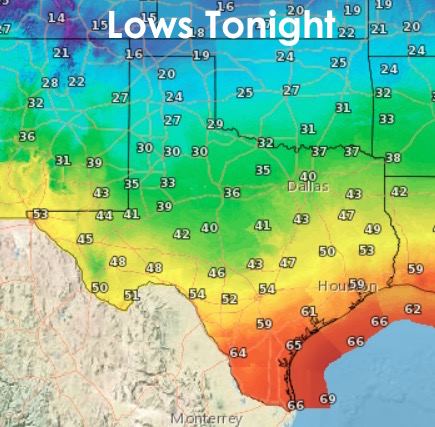
Just a quick update for everyone on what to expect today. The cold front as passed through the Dallas/Ft. Worth area and is currently oriented from northeast to southwest from Corsicana to Waco to Lampasas to Junction and south of Sonora. The front will continue to drift south today arriving along the central to upper coast after dark this evening. The coldest air will lag behind the front and arrive on Sunday evening with temperatures dropping into the 20s and 30s across northern Texas by early Monday morning. For today, highs will remain pleasant south of the front for a good portion of the day. Lows tonight won’t be all that dramatic with exception of the northern panhandle which will drop down into the 20s.
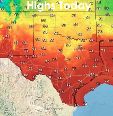
Showers and storms are likely ahead of the frontal boundary this afternoon across northeast, east and southeastern Texas. Gusty winds, lightning and small hail will be the biggest threats. There is a slight tornado threat, but that is mostly confined to parts of northern and central Louisiana. Still, folks from Longview to Nacogdoches to Lufkin to Houston and over towards Beaumont will need to keep an eye to the sky this afternoon for the threat of severe weather.
 For folks hanging around the house this evening, David will be hosting a live Q&A Session this evening on the impending Winter Weather. Guest Host John Burgdorf from DFW Scanner will be joining him as well! Be sure to bookmark the following link and plan to join us this evening! https://www.youtube.com/watch?v=JY8NtTosnBc


0 Comments