
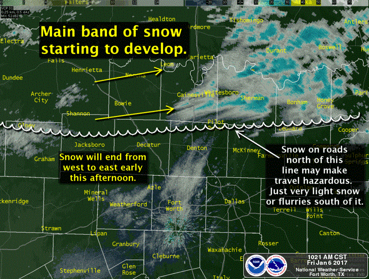
Light to locally moderate snow will continue near the Red River in Northwest Texas, Texoma, into Northeast Texas through the early afternoon hours. This fairly narrow band of snow is due to a narrow zone of enhanced lift known as frontogenesis. I’ll forgo the nerd-out phase and just say that lift will be weakening into the afternoon hours. Most of the snow should be moving out of the area by 3 to 4 PM. There is the potential for up to one inch of snow accumulation with more likely amounts of a dusting to one half inch along the Red River. This includes Wichita Falls east to Gainesville to Sherman to Paris and Texarkana. We might see some light snow develop a bit further south in East Texas this afternoon with a dusting possible down to locations like Marshall. With temperatures well below freezing any precipitation that does fall will accumulate on bridges, overpasses, and secondary roads. Give yourself a bit of extra time if snow starts to accumulate in your area.

Snow flurries or light snow will remain possible through 3 PM in the D/FW Metroplex. The northern ‘burbs like Denton to McKinney may be lucky enough to pick up a dusting in spots. Widespread travel issues are not expected, but be mindful of bridges if you get a little burst of snow. All precipitation will be moving east of D/FW (and North Texas) by 3 to 4 PM. The evening rush hour will be dry, albit very cold. The main weather story for all of Texas tonight will be the brutally cold airmass as skies clear, winds become light, and we see the bottom fall out of the thermostat.


0 Comments